|
Canada : Alberta
19.4 km (12.0 miles) ESE of Valleyview, AB, Canada
Approx. altitude: 680 m
(2230 ft)
([?] maps: Google MapQuest OpenStreetMap topo topo250 ConfluenceNavigator)
Antipode: 55°S 63°E
Accuracy: 3 m (9 ft)
Quality: good
Click on any of the images for the full-sized picture.
| 55°N 117°W (visit #3) |
 (visited by Sacha Peter) 25-Jul-2020 -- The other relatively easy confluence in northern Alberta is this one. Most of the road to get here is paved until Range Road 211, where you turn into into a "no exit" area. Upon reaching the corner of Township Road 694 and Range Road 204, you can get out of the car and walk the half kilometer north into a moist, but not muddy farm field. This year it was planted with grass, which reached up in places over two feet. There were no human beings around. I also took a picture of the sign that the previous confluence visitors 18 years ago saw. I see they installed new power lines since then. |
| All pictures |
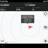
| #1: 55N117W North #2: 55N117W East #3: 55N117W South #4: 55N117W West #5: Closer to the parking spot, with the sign present #6: Township Road 694 and Range Road 204 #7: GPS Evidence #8: 360 Panorama of 55N117W ALL: All pictures on one page |


![Visit #2: [05-Aug-02] Visit #2: [05-Aug-02]](/ca/ab/n55w117v2/preview.jpg)
![Visit #1: [10-Jan-02] Visit #1: [10-Jan-02]](/ca/ab/n55w117/preview.jpg)