|

Canada : Alberta
39.0 km (24.2 miles) SE of Cline River, AB, Canada
Approx. altitude: 1870 m
(6135 ft)
([?] maps: Google MapQuest OpenStreetMap topo topo250 ConfluenceNavigator)
Antipode: 52°S 64°E
Accuracy: 5 m (16 ft)
Quality: good
Click on any of the images for the full-sized picture.


| 52°N 116°W (visit #2) | (secondary) |
![Visit #1: [08-Aug-02]](/ca/ab/n52w116/preview.jpg "Visit #1: [08-Aug-02]")

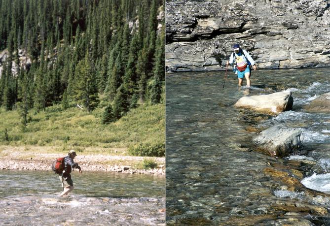
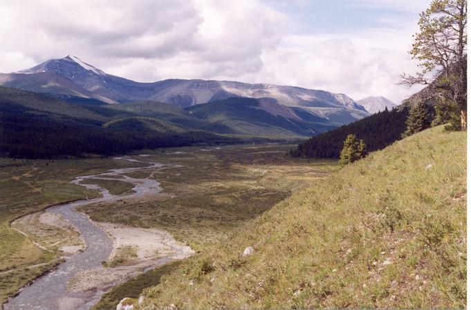
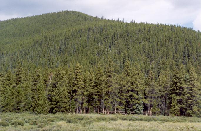
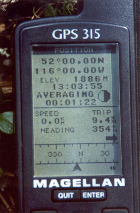
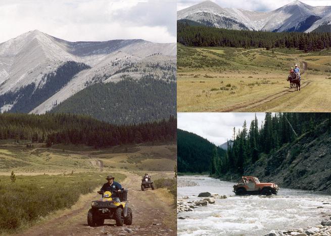
(visited by David Wasserman and Guy Germain) 10-Aug-2002 -- Except for the daunting 52N 117W and the attempted 54N 116W, 52N 116W was the only Alberta confluence from 54N south to the U. S. border that hadn't been visited before August 2002. We had scouted the nearest road access for this one when we visited 52N 115W on June 15, 2002, and were waiting for a suitable opportunity when a flurry of plans were submitted, indicating it would soon fall. Not knowing if we could be first, we decided that the beauties of the area would reward any visit. The upper Ram River area where the CP is located is within the huge Rocky Mountain Forest Reserve, and in the Upper Ram Area of Bighorn Country, whose use is currently being studied by the Alberta government. Controversy rages as to which parts of the Bighorn should be closed to various kinds of traffic: motorized, equestrian, and foot. In this case, motorized traffic refers primarily to ATVs (all-terrain vehicles, also called "quads"), but includes four-wheel-drive off road vehicles. A web site with a very personal take on the Ram River is South Ram River Rambles . Guy particularly recommends the Essay, A Natural Natural History. Our research had shown that a trail ran from the end of the road to within perhaps 200 metres of the CP, but the government topo map was only updated to 1977. We didn't know what shape the trail was in or how much use it saw. Further research on the web site mentioned above showed that the trail was heavily used by both motorized and non-motorized traffic as far as the CP, but since we don't have either horses or quads in our possession, we decided we could hike the estimated 13 kilometers each way. We knew this would involve fording Hummingbird Creek and twice fording the Ram River in both directions. Guy brought his equipment up to standard by buying a trekking pole and "paddling reef boots" suitable for fording. The end of the road for conventional vehicles for visitors to the upper Ram River is the Hummingbird Creek Equestrian Staging Area. There is a "user-maintained" camping area at the site, so we drove down from Edmonton on Friday night to spend the night there and hit the trail early Saturday morning. We followed Highway 2 from Edmonton to Red Deer, Highway 11 from Red Deer to Rocky Mountain House, Highway 752 from there to Highway 940, the Forestry Trunk Road, and then the side road to the trailhead. The staging area was busy with vehicles towing horse trailers or quad trailers. We were apparently the only visitors with neither. After setting up camp (Guy set up a tent and I slept in the back of my station wagon), we went to use the pit toilets that are the only amenity offered (but then, there's no camping fee, either), and while waiting my turn I fell into conversation with a family waiting their turn while sitting on two quads. The father told us he ran a trapline on the Upper Ram, and advised us of an alternate route to the upper Ram River that would avoid the two Ram River fords and have less horse and quad traffic. He thought the route was shorter than following the Ram. We turned in for the night. Guy assured me he was used to waking up at 5 a. m., and we could get an early start. I woke up at six, dressed in my hiking clothes, performed my morning ablutions (washing myself in the cold waters of Hummingbird Creek), ate breakfast, and then, at 6:40 a. m., went over to the tent to ask Guy if he was awake. I was rewarded with a grunt. When I repeated the question, he said, "I am now. What time is it? Oh, my goodness!" His alarm had been improperly set. Shortly afterwards, it started to rain. Guy packed up and joined me in the car, where we considered our options. We decided to wait; the weather forecast we were (barely) able to pick up on the car radio didn't call for a lot of rain. Finally, after nearly two hours the rain ended, and we set off at about 8:45. We decided to use the main trail along the Ram, since we weren't sure we could find the other route. We successfully forded the Hummingbird, which was about 8 metres wide and no more than knee-deep at the ford, put our boots back on and set off southward down the rain-muddied trail. The sky cleared up nicely, with fluffy cumulous clouds and large patches of blue. The trekking poles were a great help on the slippery patches, and the river and the rocky valley sides were a pleasure to view. A small waterfall before the first ford of the Ram provided an enjoyable rest stop. The trail ascended quite gradually. After changing to my fording sandals for the first Ram ford, I decided to keep them on and carry my boots to the second ford about a kilometer away. Reef boots aren't designed for that kind of walking, so Guy had to change footwear. After the second ford, near where Ranger Creek flows into the Ram from the side opposite the trail, the Ram curves to the west and the valley opens up into a large meadow. Approaching this section, I spotted a deer standing in the shrubbery about 50 metres away, staring at us with such intense stillness that I wondered if it was real, or a dummy set up by wildlife officers to trap poachers. I got out my camera, and shortly after I took my first exposure of the still motionless deer, three others bounded out of concealment less than one-third the distance from us of the first deer. Two of them quickly ran out of sight, but the other went toward the first deer and then turned and stopped. I took its picture, and we moved on. Guy amused himself by trying to identify the butterflies we encountered. We saw orange and black, pale yellow, pale blue, and white varieties, but that's as close as we came to naming them, lepidoptery not being among our skills. Not long after the valley turned west, a foot/horse trail diverged from the quad trail, leading up and along a ridge overlooking the river and giving fine views of the mountains further up the valley. Then the trail led downward and rejoined the quad trail through the meadows along a flat benchland on the valley's north side. We had been hiking for about three hours and had not yet seen or heard any horses or vehicles (nor had we encountered any hikers). Something moving on the trail ahead caught my eye. After we speculated on the possibility it was a grizzly, it resolved itself into a pair of quads. When we closed the distance, we found that it was the family we had spoken with the previous evening. They had come in by another route, and one of the quads had ripped out its oilpan on a rock. The functional quad was towing the broken one on a very short towrope. We exchanged greetings and commiserated with them. At this point we were only 2.5 kilometers from the CP, so we were eager to push on. Over the course of the day the trail had been drying, and by now it was easy going. At about 12:30 we reached the point on the trail nearest the confluence, within 220 metres. For the last 500 metres the meadows had ended and we had been in a forested area. On the other side of the trail was a corral, the remains of a lean-to, a fire ring and some crude tables. There was sufficient garbage around to show that not all backcountry travelers had scrupulously obeyed the instructions at the trailhead to pack out all trash. We immediately dubbed the spot the Confluence Corral. We left our packs on the tables and headed across the trail toward the confluence. The first hundred metres were flat boreal forest. Then we headed up a slope through more forest. Some 20 metres from where our GPS receivers indicated the confluence to be, we came across a recently vandalized tree. Some circling brought us to the indicated confluence, where we photographed the GPS receiver display and the surrounding trees. Our mission accomplished, we returned to the Confluence Corral for more photography of the Upper Ram River Valley, and to have lunch, as it was about 1 p. m. At this time, trail traffic began. As we ate, a series of quad convoys went past, including one towing a trailer. To my surprise, two Jeeps also went up the trail. I would have thought the fords, mud holes, and narrow trail in the forested sections would have prevented them from making it this far. Obviously, I underestimated what a determined and skilled driver with the relatively narrow and short-wheel-base combat-style Jeep could accomplish. We waved cheerily to the traffic, and they waved to us. We didn't want to give the impression we were some tree-hugging eco-freaks when we were this far from a 911 call. Finishing our lunch break, we set off back the way we had come. This time there were numerous interruptions to step off the trail to let quads go past. Where the trail was wet, the day's traffic had visibly deepened the puddles and tracks from our trip in. Some of the quadders stopped to pass the time of day; others gave us suspicious glances, and a few did both. We also met one couple on horseback, and chatted with them. Supper at a Rocky Mountain House restaurant was calling us, so we moved briskly on the return trip. The weather was holding, except for the odd windy period in the meadows. The returning Jeeps caught up with us as we were putting on our boots (rebooting?) after the first Ram River ford. The driver of the first one paused as I was landmarking the ford's location on my GPS receiver, and asked if I knew where I was. In true GPS user fashion, I replied that I knew EXACTLY where I was. He grinned and drove on. By 5:15 we had forded the Hummingbird and were back at the car. Quickly packing up, we headed home. While on Highway 752, we saw a full-grown bull moose, and had to pause while he crossed the road in front of us, stepping casually over the roadside guardrails without a pause. I regret that I had finished off the film in my camera and had not reloaded at the end of the hike. Supper in Rocky (as the locals call it) was pleasant, and we continued to retrace our route homeward, completing our journey by 10:30 p. m. The day had been very enjoyable. The walk of about 26 kilometers in beautiful mountain scenery and sunny weather was an experience we will long remember with pleasure. This confluence strikes a midpoint between the next one to the east, with its relatively flat lands and clearcuts, and the next one to the west, with its high mountains and pristine wilderness. 52N 116W has mountains, but shows the hand (or wheels) of man; tracks, however, don't equal clearcuts for depredation. |
| All pictures |
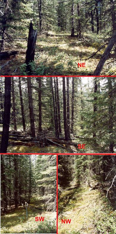
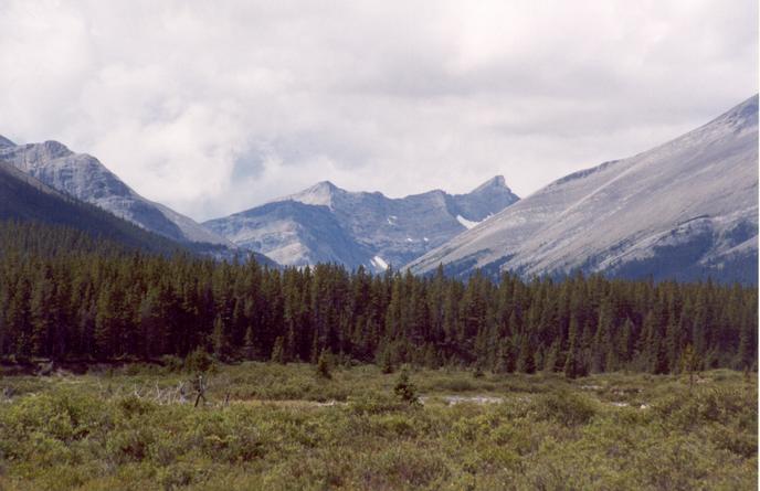
| #1: The confluence is near the centre of this photograph. #2: Trees in all directions #3: The visit involved six river crossings. #4: The falls are a great place to stop for a while. #5: The valley near the confluence has extensive meadows. #6: The recently vandalized tree near the confluence #7: The valley continues past the confluence into the mountains. #8: One of the deer we encountered #9: Jeeps, quads, and horses were more popular than hiking. #10: The zeroes tell the tale. ALL: All pictures on one page |