|
India : Orissa
9.4 km (5.8 miles) ENE of Sukinda, Orissa, India
Approx. altitude: 67 m
(219 ft)
([?] maps: Google MapQuest OpenStreetMap ConfluenceNavigator)
Antipode: 21°S 94°W
Accuracy: 5 m (16 ft)
Quality: good
Click on any of the images for the full-sized picture.
| 21°N 86°E (visit #3) |
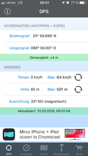
 (visited by Franz Mittermayr, Krzysztof and Tonmoy) 31-Mar-2019 -- On a very hot Sunday we started from our hotel in the city of Jajpur Road towards north. As google maps showed us the way we had almost no wrong turns. Coming closer and closer to the point we got stuck in a forest where trees blocked our way. We had to leave the car and walk. Unfortunately a wall appeared which made us doubting to reach the point. But walking around the wall a plain fields came into view. We walked leisurely some hundreds meter towards north west and kept always an eye on our GPS device. Loneliness and the sun almost on the zenith gave us the feeling of adventure. Finally we got our position as the coordinates 21 north and 86 east appeared on the GPS device. Making the pictures towards north, east, south and west and a panorama photo we accomplished our mission. Summarizing I wanna say it was an easy trip with a variety of plants and trees on our way. By the help of an smartphone app we pictured some plants and determined the names. Finding the way back was easy because there was only one small path. PS: Thanks to the native driver that he didn’t give up when the road disappeared and we continued moving inside the wood. |
| All pictures |
| #1: overview #2: north #3: south #4: east #5: west #6: gps coordinates #7: overview panorama #8: overview panorama ALL: All pictures on one page |


![Visit #2: [28-Sep-08] Visit #2: [28-Sep-08]](/in/all/n21e086v2/preview.jpg)
![Visit #1: [10-Mar-08] Visit #1: [10-Mar-08]](/in/all/n21e086/preview.jpg)