|

China : Húnán Shěng
10.1 km (6.3 miles) SSE of Longhu (Guǎngxī), Húnán, China
Approx. altitude: 1043 m
(3421 ft)
([?] maps: Google MapQuest OpenStreetMap ConfluenceNavigator)
Antipode: 25°S 69°W
Accuracy: 5 m (16 ft)
Quality: good
Click on any of the images for the full-sized picture.


.")


| 25°N 111°E |

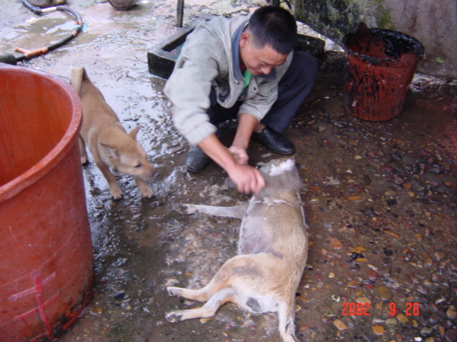
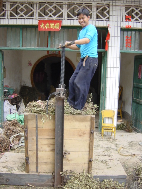
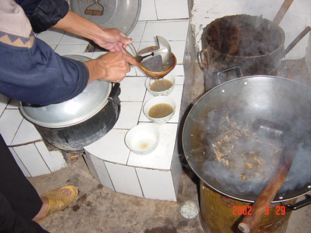
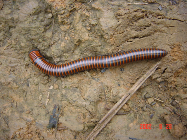
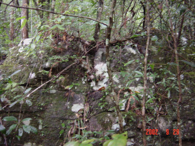
(visited by Targ Parsons) 29-Sep-2002 -- With four days up my sleeve over the Chinese National Day holiday, I chose to try for this confluence, expecting that it might prove a bit of a challenge. It is located in the extreme southwest of Hunan Province, in a fairly remote, mountainous and densely forested region of Jiangyong County, in a small, nipple-shaped piece that protrudes into neighbouring Guangxi Autonomous Region. It is actually not all that far from Guilin, the latter being a must-see tourist destination, famous for its "pointy mountains." To get to the confluence, I caught the Hong Kong-to-Shanghai intercity train on Friday afternoon, getting off in Chenzhou where I stayed the night, then spent most of Saturday travelling east by road on a succession of three buses. Although the highways were in pretty reasonable condition, we were nonetheless forced to brake suddenly and frequently in order to avoid running over meandering dogs. They were very prevalent, and treated the road as though it were their own private recreation ground, totally oblivious to the heavy vehicles thundering down upon them. During the final leg of my journey, as the bus travelled alongside the Taoshui River, I was fortunate enough to witness several cormorant fishermen sending their trained birds into the river to catch fish. The cormorants have ropes tied around their necks that are just tight enough to prevent them from swallowing the fish, but loose enough for breathing. These fishermen were the genuine article, unlike those who earn their keep by putting on a show for the tourists around Guilin and Yangshuo. When I arrived in Cushijiang, 10 kilometres north of the confluence, there were still enough daylight hours remaining to permit a little exploration of the immediate vicinity. I soon discovered one use to which the large canine population was put, when I stumbled upon an unfortunate individual just freshly slaughtered and now being prepared for cooking, as one of its brethren looked on apprehensively, no doubt contemplating the day when dog might next be on the menu. Jiangyong County is inhabited by the minority Yao Nationality, who like to wear decorative ornaments made of silver, jade and dog bones. So this is another legacy the four-legged inhabitants have to look forward to. The Yao Nationality is a matriarchal society that counts among its claims to fame having invented Nüshu, a secret script known only to women, and for churning out an unending supply of baby girls for adoption by eager American couples. I learned of one such couple who is adopting them so eagerly in fact that their own personal crop may soon hit double digits, and Nüshu may one day replace English as the vernacular in San Jose. (Well, among the women, anyway.) I had time to pay a visit to the local monument, an ancient pagoda now very much in disrepair. It was possible to reach what remained of the top of the pagoda by climbing up a crumbling internal spiral staircase, which I did, but not without a good deal of trepidation; this pagoda is well past its use-by date. The main industry in the area is the manufacture of sesame oil. Right across the street from the guesthouse where I was to spend the night, I witnessed some leaves being manually (pedally?) pressed, ready for oil extraction. Before retiring for the evening, I made arrangements with a local motorcyclist to pick me up at 6:30 a.m. the following morning, and take me to the small village of Qingxiyuan, which is the closest point to the confluence accessible by road. The next morning, my motorcyclist was very punctual, and we were on our way on time at 6:30 a.m. However, when we had reached only about half way, it began raining, and we were forced to take shelter in a village called Huangjinshan, where a local couple welcomed us into their home to drink some da you cha (oil tea), which is something else the Yao are famous for. Da you cha is made as follows. The tea leaves are fried in sesame oil, then raw ginger and salt are added. The whole lot is simmered together, with the ingredients being pounded as they cook. The result is a thick soup that is poured over puffed rice, fried soybean and fern chunks. It sounds ghastly, but actually it's not too bad. The ginger flavour is kind of all pervading though, and tends to mask everything else. The rain soon stopped, and we were on our way again, arriving in Qingxiyuan at 8 a.m. Qingxiyuan is slightly less than four kilometres northeast of the confluence, and lies at an altitude of just 345 metres. I had managed to find an extremely detailed topological map of the area at the Hong Kong Central Library, and this proved indispensable in determining a viable route into this confluence. From Qingxiyuan, I climbed steadily for an hour and 20 minutes up a pretty steep path. At this point, I was now two kilometres from the confluence, and at an elevation of 723 metres. The only sounds to be heard were those of birds singing, insects chirping, the flow of a distant stream, and the heavy rhythmic thumping of my own heart from the exertion of the climb. The ground and foliage were still quite damp from the early morning shower, and the air was beautifully fresh. As I continued along, I came across the biggest and most magnificently coloured millipede I've ever seen. He was sitting quietly on the path, minding his own business. I decided to give him a gentle nudge, just to reassure myself that he really was alive, at which point he immediately curled up into a defensive ball, and I felt guilty for having so rudely disturbed him. The next hour and 20 minutes were much easier than the first, as the path levelled off somewhat, making for an extremely pleasant Sunday walk in the woods. At 10:40 a.m., I found myself only 35 metres from the confluence, still on the path! This was pretty amazing, considering the distance I had covered over very hilly terrain. I had not imagined finding the confluence would be this easy. I left the path and scrambled down the wooded slope to locate the exact spot. It was at an elevation of 1,024 metres (a nice round number for someone who has worked all his life in the computer industry like me). I recorded the views to the north, south, east and west. An enormous boulder immediately uphill from the spot dominated the latter view. The walk back out was equally as pleasurable as the walk in. I arrived at Qingxiyuan at 1:40 p.m., where I had a quick lunch before obtaining a ride back to Cushijiang in the cab of a small truck. It was now mid afternoon, and with two full days still remaining before I had to be back home, I decided to use the time to go and check out 25°N 110°E. |
| All pictures |
| #1: Looking south. #2: Freshly slaughtered dog being prepared for cooking, as another looks on. #3: An ancient pagoda near Cushijiang. #4: Leaves being pressed, ready for extraction of sesame oil. #5: Making "da you cha" (oil tea). #6: Large, magnificently coloured millipede. #7: Spot on: N 25°00'00.0", E 111°00'00.0" #8: Looking north. #9: Looking east. #10: Looking west. ALL: All pictures on one page |