|

Morocco
14.1 km (8.8 miles) SE of Sebt Gzoula, Marrakech-Safi, Morocco
Approx. altitude: 457 m
(1499 ft)
([?] maps: Google MapQuest OpenStreetMap ConfluenceNavigator)
Antipode: 32°S 171°E
Accuracy: 5 m (16 ft)
Quality: good
Click on any of the images for the full-sized picture.


| 32°N 9°W |
")
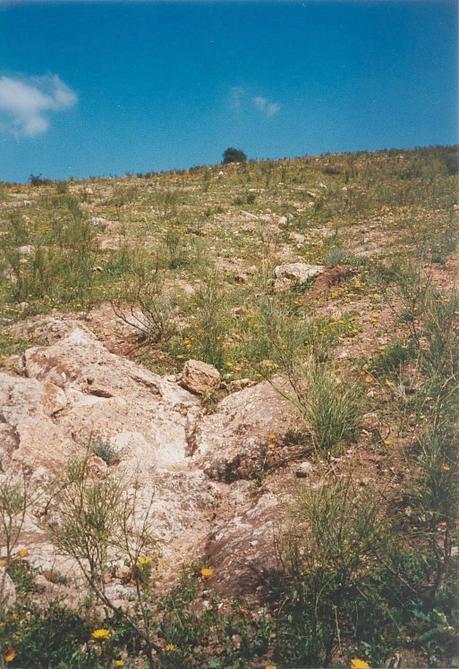
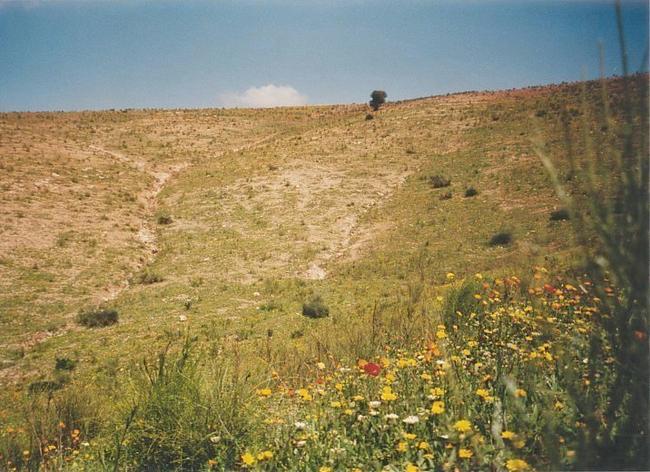
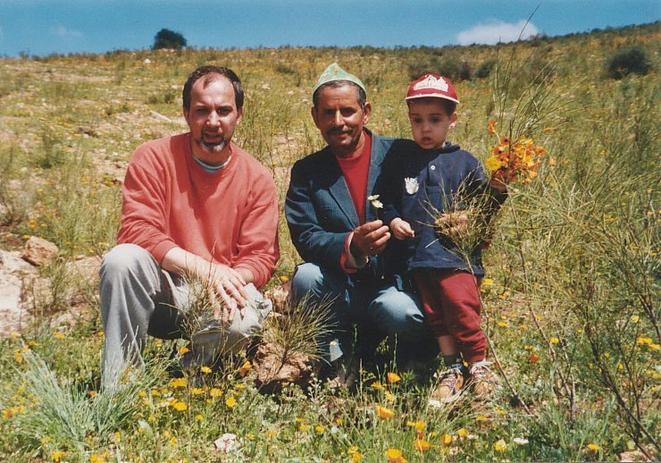
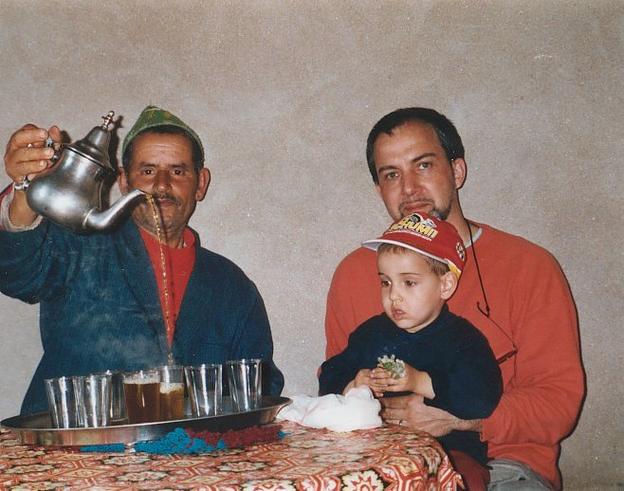
(visited by Gerhard Kaufmann, Jamila Ahejjam and Marwan Kaufmann) 19-Apr-2002 -- After having got to the Confluence 32°N 8°W only 40 km north of Mrrakš yesterday evening, this morning we left the city on the road P 9 towards Asfī that we had unintentionally already found the day before. This road at first runs in north-western direction and passes through the western parts of the Jbīlāt hills covered with flowers in many different colours. At a junction marked by a few houses, the road P 12 branches off in a more western direction crossing the western parts of the Bahīra plain. After passing the town Šamā`iyya, the road cuts through a hilly region while descending into the coastal plain and runs on towards the city of Asfī on the coast of the Atlantic Ocean. At the beginning I had the intention to pass north of the Confluence, then turn south-west on the road P 8 to al-Ṣuwayra, and then approach it from the west via the road 6523 and the village Khamīs-Nga, as my roadmap didn't indicate a passable road to the Confluence from its north or east side. But when we passed near the village of Sīdī Tījī 20 km north of the Confluence, we found that there existed now a very good road in the direction of Khamīs-Nga after all. In the area of Sīdī Tījī several very strange looking hills with edged contours jutted out of the surrounding land. When we came nearer, I could see that these hills had been partly dug away because they consisted of marble. Now following the road to Khamīs-Nga, we passed a few smaller quarries and stone mills, so they might be a reason for the recent reinforcement of this previous dirt road. Soon the region got a very charming appearance, gently rolling hills, scattered farms, small villages, fields of barley and fields full of flowers, sometimes the dark yellow colour of marigold covered a whole hill. This was one of the loveliest sceneries (Picture #8) we had seen during all our voyages in this land, and for everyone travelling in this part of Morocco in springtime I would like to recommend this road through the northern parts of the Šiyādma region as a must. The road was swinging widely through this beautiful landscape, but eventually we approached Khamīs-Nga and passed only 2.5 km west of the Confluence. A dirt road branched off in the right direction at 32°0'20"N 9°1'27"W and we followed it, although it turned out to become quite difficult to drive along with our normal streetcar. The carriageway mounted a small hill, on the slope it was washed out by rain water and I had a hard job to navigate cautiously around the boulders and grooves in the road. When it finally seemed too dangerous to continue, we parked the car on the roadside and continued on foot, the Confluence only 1 km ahead. We passed a farmhouse, walked along the carriageway and tried to approach the Confluence, but we soon saw that we would have to cross a small valley entirely clad out with barley fields. So we returned to the farmhouse to ask for a possible better way to get there. It turned out that the farmer was a very helpful man. He told us that at first they had taken us for kidnappers spying out the area, as in rural regions children frequently disappear, being abducted and sold to rich families in the cities, where they have to work hard for years as servants in the households. But when we explained that we only wanted to take some photos on the other hill and asked for a way to get there, he recommended us first to take our car in front of his farmhouse, where he would be able to keep an eye on it. Then he allowed us to walk through the barley fields, as there was no other way to get near the Confluence. So we crossed the small valley on the edge of a field, but on the opposite hill we saw that we had to descend in still another valley behind. At this point we noticed that the farmer obviously couldn't help following us to see what we were going to do. We descended together in this second valley and eventually found the Confluence 32°N 9°W at 2:15 p.m. GMT (UT + 0) near to a bare rock (Picture #3) some steps east of it. The GPS receiver (Picture #6) indicated an altitude of 479 m (this is quite curious because the Confluence 32°N 8°W that we found the day before was EXACTLY at the same altitude!) and an accuracy of 4 m. This valley had steep walls on three sides; only the side we came down was a little wider, so the photos show only the slopes of this valley. But the lack of view wasn't really a disadvantage because the valley itself offered a wealth of flowers (Picture #1) of all colours to admire: poppy, marigold, lilies, mallow, pincushion flower (scabiosa), and many, many more that I didn't know or don't remember now. The farmer told us that only two weeks ago the whole area had been absolutely bare except for some dry bushes. Marwan collected a big bouquet of all the flowers, and the farmer (Picture #7) helped him to add more and more to it. When we returned together to the farmhouse, the farmer invited us to come in and have a tea. This time we accepted because we had enough time and we were in need of refreshment. All his family showed up to greet us, we entered a living room next to the yard that obviously was only used on special occasions, and sat down on carpets for a rest. The third Confluence in three days also required a little celebration. The farmer, his name was Muḥammad Naḍīf, began to prepare a pot of mint tea (Picture #9) for us. Called "Atay s-liqamt" in Tašilḥit, "Šāy bi-na`nā`" in Arabic, the typical Moroccan mint tea combines the taste of mint and the invigorating effect of green tea. It is prepared after every meal and also as an honour to guests. Traditionally, it gets boiled in a small ceremony on a charcoal basin (today often a gas burner), and is served very sweet. When we hardly had the first glass of tea, the farmer's wife and two of his daughters came in with a giant plate that they put in the middle of the low table. On the plate was a round flat loaf of freshly baked bread, still warm and covered with self-made butter, which slowly melted and ran over the loaf. This was a welcome surprise, because we hadn't eaten since our breakfast in Mrrakš, and moreover it was really delicious and filling. After some more glasses of tea, we prepared to leave, but first we got half a dozen of fresh eggs and thyme to take with us, we had to drink each a big cup of buttermilk, and were invited very heartily to come back at any time and to stay with them if we like. We could only reward them their hospitality with some small presents to the children. For them, their hospitality is a fundamental part of their culture. For me, coming from a so-called "developed" western country, it was shaming. We left this wonderful region and drove along the road P 8 and later on the coastal road 6537 to al-Ṣuwayra, the windy town, where we arrived at late afternoon. Narration began at 30°N 9°W and will be continued at 31°N 9°W (Second visit) |
| All pictures |
| #1: The CP 32°N 8°W seen from west (Confluence in front of the bright rock in the centre) #2: View towards north from Confluence #3: View towards east from Confluence. The bare rock is only a few steps from the Confluence #4: View towards south from Confluence #5: View towards west from Confluence #6: GPS receiver display #7: My son, me, and the friendly farmer at the Confluence #8: An impression of the lovely scenery all around #9: Invitation to a wonderful glass of mint tea and more... ALL: All pictures on one page |