|

Morocco
2.7 km (1.7 miles) SE of Ouled Ben Azzouz, Casablanca-Settat, Morocco
Approx. altitude: 213 m
(698 ft)
([?] maps: Google MapQuest OpenStreetMap ConfluenceNavigator)
Antipode: 33°S 172°E
Accuracy: 6 m (19 ft)
Quality: good
Click on any of the images for the full-sized picture.


| 33°N 8°W |

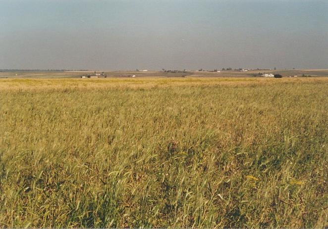
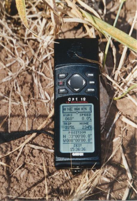
(visited by Gerhard Kaufmann, Jamila Ahejjam, Marwan Kaufmann and Farida Ahejjam) 26-Apr-2002 -- When we came back to Agadir from our last successful Confluence 31°N 9°W (Second visit), we really were in need for some days of relaxation. Since we had been in Mrrakš, I got a terrible backache after being some hours behind the wheel, so that I nearly couldn't get out of the car any more. But after a few days of rest, things went better, and we still had the intention to visit another brother-in-law of mine who recently had moved to the city of Khurībga, 370 km NE of Agadir and 100 km SE of Casablanca. Therefore, we bought tickets for my wife's sister Farida and us for a night coach to Casablanca. In the light of the nearly full moon, we passed once more the Confluences 31°N 9°W and 32°N 8°W at only a few kilometres distance. We arrived in the morning of 25 April in Casa, and after a short stay we took another coach to Khurībga in the afternoon. Khurībga is a nice little town and centre of a region called "Plateau des Phosphates". East of it are many plants with open-cast mining of phosphates, one of the riches of Morocco that is transported via railway to Casablanca and shipped to the entire world. My brother-in-law Mbark works in one of these plants as electrician. When we talked to him about our plans to rent a car, he had bad news for us: To his knowledge there didn't exist any car rental in Khurībga. This information nearly shattered all my plans! But fortunately and to my great relief we found out the next day that there was yet a single car rental that had opened only a few months ago. Oof! We rented a car for one day on the spot and prepared for our next Confluence hunting. As it was already noon, I decided to leave the Confluence close to the town for the next morning and to begin with the Confluence about 100 km west of Khurībga. We took Farida with us and drove west on the road P 13 to Bin Aḥmad, where we took the short cut via the road S 115 towards Sttāt. We bought something to eat and drink there and continued on the road S 105 to al-Jadīda. After 30 km the road S 109 leading to Awlād `Abbū branched off to the right and brought us close to the Confluence. We eventually located it 900 m beside the road in an area of vast barley fields. To get a little bit closer, I followed a dirt road into the fields, but this didn't bring us closer than 500 m either. In the end we parked the car 700 m S of the Confluence, first had our snacks (we had learned from our mistakes!), and then looked for a way to approach the Confluence. As the fields aren't tilled with large machines but only with the work of men, donkeys, cattle and maybe some tractors, there are no cart-tracks between the fields. Therefore, to avoid trampling over the fields, the only possibility is to walk exactly on the edges of the fields that are often marked by stones picked up in the fields and put aside. In this manner we tried to get closer to the Confluence 33°N 8°W as straight as possible, and at last found it at 3:30 p.m. GMT (UT + 0) some steps inside one of these large barley fields (Picture #1). The GPS receiver (Picture #6) indicated an altitude of 234 m and an accuracy of 6 m. The scenery all around was very flat and with little outstanding features, only some low hills far to the East and South, and a few scattered farmhouses, the nearest one 500 m SW of the Confluence, belonging to a community named Sīdī al-Huwāriyy al-Ḥnīna. Before returning to Khurībga, we drove a little further south on the road S 105, crossed the river Umm al-Rabī` ("Mother of Springtime" in Arabic) in a valley deeply cut into the surrounding land, the narrow bridge having only one lane, and then turned east on the road S 128 to visit the imposing 18th century castle Qaṣba Būl`awān (Picture #8) 16 km S of the Confluence. This castle is standing very picturesque on a protruding rock flown around on three sides by a bow of the river in its valley deep below. There is a walk along the battlements on its walls, passing seven ramparts. Inside the walls, a broken tower and a mosque are still standing. We followed the road S 128 east along the Wādiy Umm al-Rabī`, it was now soon getting dark, crossed the river again over the dam wall of the Imfūt reservoir and reached the road P 7 - 34 km south of Sttāt. Having driven this day about 360 km, we returned at 10:30 p.m. to Khurībga where a big plate of Cuscus waited for us. |
| All pictures |
| #1: The Confluence 33°N 8°W in the barley field towards NE, marked by a heap of stones #2: View towards north from Confluence #3: View towards east from Confluence #4: View towards south from Confluence #5: View towards west from Confluence #6: GPS receiver display #7: My son and me at the Confluence #8: Qasba Būl`awān in the last light of day, 16 km S of the Confluence ALL: All pictures on one page |