|
United States : Illinois
3.4 miles (5.5 km) SW of Maroa, Macon, IL, USA
Approx. altitude: 214 m
(702 ft)
([?] maps: Google MapQuest OpenStreetMap topo aerial ConfluenceNavigator)
Antipode: 40°S 91°E
Accuracy: 4 m (13 ft)
Quality: good
Click on any of the images for the full-sized picture.
| 40°N 89°W (visit #2) |
 (visited by Michael Kessler) 21-Oct-2018 -- On a business trip to Decatur, IL, I decide to visit this confluence, as it has been visited in 2001, over 17 years ago. This confluence was located in fields west of Janvrin Road, which is a gravel road. What i noticed first when I remembered the pictures from the last visit (2001) is that a lot of wind power plants have been setup since in the surrounding. I just parked my car on Janvrin Road and walked to the confluence, which is about 500 meters west of the road. As corn or soy will grow in almost every field in Illinois in spring/summer, it makes sense to visit this confluence after it has been harvested. No special gear but good shoes are needed to walk from the road to the confluence. |
| All pictures |
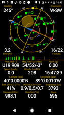
| #1: North view from the confluence. #2: East view from the confluence. 500 meters towards east lies the road with the parked car #3: South view from the confluence. #4: West view from the confluence. #5: GPS screenshot. #6: Me at the confluence (Background is towards east) ALL: All pictures on one page |


![Visit #1: [31-Mar-01] Visit #1: [31-Mar-01]](/us/il/n40w089/preview.jpg)