|

Italy : Lazio
1.3 km (0.8 miles) SE of Anticoli Corrado, Roma, Lazio, Italy
Approx. altitude: 422 m
(1384 ft)
([?] maps: Google MapQuest OpenStreetMap ConfluenceNavigator)
Antipode: 42°S 167°W
Accuracy: 50 m (164 ft)
Quality: good
Click on any of the images for the full-sized picture.


| 42°N 13°E (visit #1) |
![Visit #5: [25-Dec-22]](/it/all/n42e013v5/preview.jpg "Visit #5: [25-Dec-22]")
![Visit #4: [05-Jan-18]](/it/all/n42e013v4/preview.jpg "Visit #4: [05-Jan-18]")
![Visit #3: [10-Nov-17]](/it/all/n42e013v3/preview.jpg "Visit #3: [10-Nov-17]")
![Visit #2: [02-Aug-06]](/it/all/n42e013v2/preview.jpg "Visit #2: [02-Aug-06]")
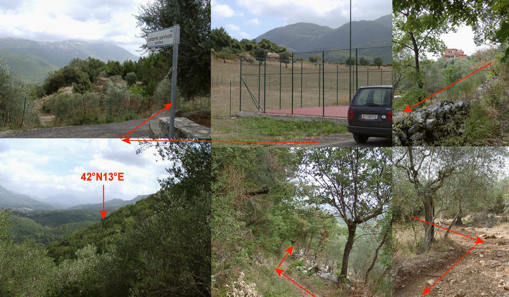
 (visited by Hans Augdoppler) 09-Sep-2001 -- Coming from After I crossed this nice village followed by some investigations I found a path which led down into the valley towards Marano Equo, towards the CP. After a steep downhill walk for about 200 m, I found a path leading in desired direction. After I had passed a private garden the path became more or less impassable. Thorn bushes are growing across and on both a dense jungle of bushes and small trees can be found. I passed the CP in a distance of about 50 m. A direct access seems to be nearly impossible since the terrain is very steep and the thorns are not friendly to humans. So I continued to follow the path in order find an access from the other side. After ~ 150 m I found a cave which was used some time ago as shelter. But this was the end of the path in front of a cliff. I returned and tried several times to enter the bush. Since I could net get a proper GPS reading, I had no compass and nevertheless a lot of thorn stuck already in my head and arms I gave up to get closer. At the closest clearing where you can see Marano Equo and the GPS reading was quite stable I put up the reference plate.
The way back and especially up to the village was a bit harder and finally I was totally wet when I arrived at the car. In total it took me more or less three hours and not even a full success. I calculated the remaining daylight time and in spite of the expected rush hour around Roma I decided to skip Note: Now I know that there is a jungle in Europe – a nice and interesting experience. |
| All pictures |
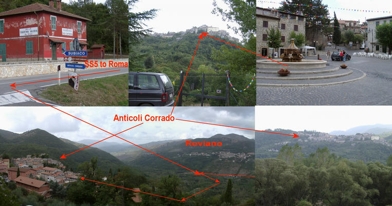
| #1: Close to confluence with view to Marano Equo #2: Arsoli and the map showing the approach #3: Anticoli Corrado and the surrounding landscape #4: From Anticoli Corrado downwards to the spot #5: Using a jungle path towards the target, more and more difficult #6: A cave close to CP formerly used as shelter #7: Reference plate ~50 m from exact CP with GPS reading and strange sign #8: Panorama towards east - Marano Equo ALL: All pictures on one page |