|
Lithuania
6.0 km (3.7 miles) W of Valdeikiai (Panevėžys), Šiauliai, Lithuania
Approx. altitude: 50 m
(164 ft)
([?] maps: Google MapQuest OpenStreetMap ConfluenceNavigator)
Antipode: 56°S 156°W
Accuracy: 12 m (39 ft)
Quality: good
Click on any of the images for the full-sized picture.
| 56°N 24°E (visit #3) |
 (visited by Rainer Mautz and Der Schneemann) The story continues from 56°N 23°E.
26-Sep-2020 -- We reached this confluence point on day #47 on our leg from Pakruojis to Pasvalys of our hiking trip to St. Petersburg. The confluence is located 10 km east of the town Pakruojis and just 1500 m north of the main road 150 on an agricultural field. The confluence can be easily accessed from the little county road 2903 from the village Balsiai that is about 1000 m north-west of the point. Right at the confluence, there is a huge and deep ditch that separates two already ploughed wheat fields from each other. In order to minimize the time at the confluence and to catch up with Elionora as quick as possible, I decided not to descend into the deep ditch. After the visit I ran back to our route and caught up with Elionora half an hour later. She was to happy get released from having to carry the big backpack (which I had given her previously to be able to run to this point). It took us all day to reach the town of Pasvalys, where we spent the night. We hiked one more day and then returned back home to Switzerland. Hopefully we can finish our hiking trip in 2021, but who knows… A summary of the trip can be found here
CP Visit Details:
The story finishes here. |
| All pictures |
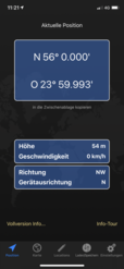
| #1: The Confluence from 15 m Distance #2: View to the South #3: View to the West #4: View to the North #5: View to the East #6: GPS Reading #7: Ground Zero #8: The Confluence Hunters ALL: All pictures on one page |


![Visit #2: [29-Jul-16] Visit #2: [29-Jul-16]](/lt/all/n56e024v2/preview.jpg)
![Visit #1: [14-Jul-01] Visit #1: [14-Jul-01]](/lt/all/n56e024/preview.jpg)