|
Moldova
S of Valya Kolonitcei, Chişinău, Moldova
Approx. altitude: 70 m
(229 ft)
([?] maps: Google MapQuest OpenStreetMap ConfluenceNavigator)
Antipode: 47°S 151°W
Accuracy: 5 m (16 ft)
Quality: good
Click on any of the images for the full-sized picture.
| 47°N 29°E (visit #2) |
 (visited by Rainer Mautz) 15-Sep-2019 -- Actually, we walked 2400 km from Zurich to Moldova to visit this confluence point. As part of our hike network the walk eastwards is one of the cardinal directions we are walking stepwise. The day before confluence day, we reached Moldova’s capital city Chișinău and spent the night in a fine hotel after a long and hot hike through the agricultural land of eastern Romania and western Moldova. From our hotel in the city center, the confluence is only 15 km away. Unfortunately, the confluence lay not on our route, so I considered to rent a bicycle to visit it quickly. But bicycle rental turned out to be complicated such that I decided to take a taxi. I know it is ridiculous to walk 2400 km and take a car for the remaining 15 km. Normally people would do it vice versa. But walking to the point would have required an extra day which we didn’t have because in the afternoon of confluence day would be our flight home to Zurich. The next morning at 6:30 AM I took a taxi to the confluence. Communicating to the taxi driver where I wanted to go was difficult due to a missing common language. But after I had marked the point on the driver’s mobile phone, he easily could navigate to it. I let the driver stop 500 m from the confluence and walked to the exact location. The confluence is located in the Chișinău District right at the border to Criuleni District in an agricultural area. It is in a valley called Valea Coloniţei right at the edge of a village with the same name. The exact location is on a track behind a row of houses, just 5 m from a fence. Just 12 minutes had passed and I was back to the taxi that waited for my return. At 7:30 AM I was back to our hotel – time to have breakfast and walk to the Airport of Chișinău. CP Visit Details:
|
| All pictures |
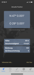
| #1: The Confluence from 50 m Distance #2: View to the South #3: View to the West #4: View to the North #5: View to the East #6: GPS Reading #7: Ground Zero #8: The Confluence Hunter #9: View from 200 m #10: Church in Chișinău ALL: All pictures on one page |


![Visit #3: [25-Jul-23] Visit #3: [25-Jul-23]](/md/all/n47e029v3/preview.jpg)
![Visit #1: [17-Sep-03] Visit #1: [17-Sep-03]](/md/all/n47e029/preview.jpg)