|

Burkina Faso
7.7 km (4.8 miles) SSE of Dounlia, Centre-Sud, Burkina Faso
Approx. altitude: 208 m
(682 ft)
([?] maps: Google MapQuest OpenStreetMap ConfluenceNavigator)
Antipode: 11°S 179°E
Quality: good
Click on any of the images for the full-sized picture.


| 11°N 1°W (visit #1) |
![Visit #2: [02-Aug-07]](/bf/all/n11w001v2/preview.jpg "Visit #2: [02-Aug-07]")

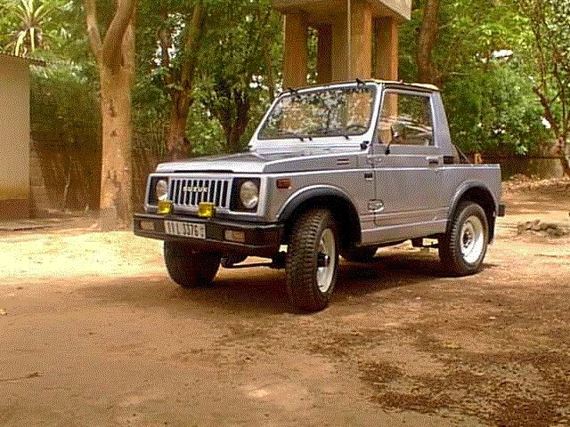
(visited by J. Baker Hill) 16-Nov-2000 -- I had to make a trip south nearly to the Ghana border of Burkina Faso, and as usual I scouted the map to see how close I might be to a Confluence. Sure enough, there was one, 11N 1W, some 11 kilometers southwest of the village I was to visit, Tiébélé. In fact I had been to the Ghana border some 17 years earlier, long before I had thought about confluence points. The point I had reached was some 2.3 kilometers from the Confluence, so I knew it could be done. Little did I know what an effort it would take. My wife, Gail, and I set out early in the morning in our little '84 Suzuki SJ 410 4x4. We visited some in Tiébélé, 2.5 hours south on reasonable roads, before setting out about noon for the Confluence. I remembered that the trail was bad, but 17 years of neglect had not done it any good at all. Many sections were covered with rock to render them passable in the rainy season and we bounced incessantly on the Suzuki's leaf springs. Other sections were simply mud in the rainy season and all the ruts, hoof marks, and footprints had dried into the surface, making it just as bouncy as the rocks. There were two deep ravines or washouts but the little Suzuki took them in stride. We stopped under a tree to eat our picnic lunch, but as often happens in our area we had an audience, so it was not such a pleasant experience. We passed through a border market in the village of Tangassogo and continued on a couple of kilometers. The basemap in my GPS said we were still north of the Ghana border but I figured it would be on the 11th parallel according to my map from the Burkina National Geographic Institute, and we were already south of that. So we parked under a spreading baobab tree and set out on foot to the west, towards the Confluence, which my GPS said was 2.3 kilometers distant. The temperature was 99° F (37° C) in the shade with very low humidity, and by the time we had walked about 800 meters Gail had had all she could take. So I parked her under a tree with the water jug and set out at a fast pace to search for that arbitrary point. We were following farm trails at this point and they crossed back and forth over the 11th parallel. I saw proof that we were in Ghana at one point where there was a large concrete pillar right on the parallel. It read Ghana on the south side and Burkina Faso on the north. Eventually there were no more trails and I struck out directly for the Confluence through dried-up cotton and sorghum fields. I was hopeful it would be more picturesque, but I ended up, as usual in our area, in a farm field. There was a house about 100 meters distant, in Ghana, and I could catch just a glimpse of the Peak of Nahouri, which rises to a majestic 447 meters, the highest point in south central Burkina. I tried to make the GPS read the exact latitude and longitude but it was drifting for some reason and I was out of time. I still had a 30-minute walk back to the car, 1.5 hours of torture back to Tiébélé, and 2.5 hours back to our home in Ouagadougou. The little old Suzuki ran like a champ at a near-maximum speed of 95 kilometers once we were back on the pavement, and we made it into Ouagadougou by 6:30, although it was already dark. Upon weighing myself I found I had lost four pounds! |
| All pictures |
| #1: Looking southwest towards a house in Ghana #2: Looking northeast into Burkina Faso #3: Looking south into Ghana #4: The GPS reading fairly close to the numbers #5: A house of the Kasena tribe just south of the border in Ghana #6: Our faithful but bouncy '84 Suzuki SJ 410 ALL: All pictures on one page |
| Notes |
|
The borderline with Ghana is running about 26 m west of the Confluence. |