|

Mali : Tombouctou
26.0 km (16.1 miles) N of Tombouctou, Tombouctou, Mali
Approx. altitude: 267 m
(875 ft)
([?] maps: Google MapQuest OpenStreetMap ConfluenceNavigator)
Antipode: 17°S 177°E
Accuracy: 16.0 km (9.9 mi)
Quality: good
Click on any of the images for the full-sized picture.


| 17°N 3°W (visit #1) | (incomplete) |
![Visit #2: [27-Jan-07]](/ml/all/n17w003v2/preview.jpg "Visit #2: [27-Jan-07]")

(visited by J. Baker Hill) 05-Jul-2001 -- I had to make a trip up to Timbuktu, Mali (Tombouctou in French) to accompany a journalist / photographer team. As is my custom before making a trip I loaded the appropriate map set into my trusty Garmin III+ and scouted for any possible confluence points. Yes! There was 17N 3W a scant 25 kilometers north of the legendary desert city. I had no doubt I would find it and thus continue my long streak of first Confluences in the country. Little did I know... We flew into Tombouctou's new, modern airport, and checked into the Colombe Hotel, which to our surprise was air-conditioned and had a decent restaurant on an upstairs patio. I spent the first couple of days getting my team situated to tell their stories, doing the usual tourist-type things, etc. I had thought of hiring a camel to ride out to the Confluence but after riding one out to a village about three kilometers out in the dunes, I gave up that idea! Especially when the camel driver told me that to go the distance I was considering could take up to 4 hours one way, time that was not at my disposition. I was finally able to hire Mahamane, a surly, middle-aged, bald and plump driver with an ancient Land Cruiser without losing my shirt. I checked the Cruiser over in order to ascertain its propensity for leaving us stranded in the desert (which is all there is north of Tombouctou). It looked like it ought to go the distance. Then I tried to explain to Mahamane where I wanted to go. He did not understand. "But, there's nothing up there!" He had no clue what longitude or latitude were and could have cared less. So I finally got him to agree to head northeast in the direction of the "road" marked on my MapSource map. He immediately headed northwest. When I questioned him about this he said that the road would soon turn northeast. I waited a couple of kilometers. These kilometers were difficult ones, in deep sand, and Mahamane did not seem to be an expert driver in the sand. The road continued northwest. I finally convinced him to turn around and head back after five km and about 20 minutes. He headed northeast immediately upon our return to the city, but we only got a few hundred meters before the road disappeared into a huge curved sand dune. No outlet. We were forced to turn back, and this with great difficulty due to the depth of soft sand. Back to Tombouctou again, and finally we were following the track marked on my GPS, more or less. In many places the road was well-defined; in others it was covered with sand and obscured. I had Mahamane turn due north where indicated after a few kilometers. The road was initially easy to follow, but then it petered out. I could tell the driver was frustrated, as he headed off into the desert, making his own road. This he did for about half an hour, fuming and mumbling, and following my directions. He kept asking, "isn't this enough?" and I kept trying to keep him going. Finally I saw that it was a useless proposition after we had spent nearly two hours and I was still more than 15 kilometers from my goal. I reluctantly agreed for him to turn around. He now went much faster in his effort to get home and spend my money. He was almost launching the Cruiser over the dunes, sliding in the turns, and paying no attention to the bumps. I told him goodbye after filling his tank (32 liters of diesel!) without many regrets. Next time, I will hire a younger and more agreeable driver, start out earlier, and find someone familiar with the desert to the north. Or maybe I will take a camel! |
| All pictures |
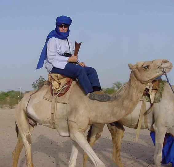
| #1: This is where Mahamane had had enough, 16 kilometers from the Confluence #2: This shot of the GPS tracks shows how we wandered looking for the right road around Tombouctou #3: Looking east before we turned around and headed back in defeat #4: This is how I am going to attempt it next time, in my Tuareg suit and all! ALL: All pictures on one page |