|

United States : Wisconsin
3.6 miles (5.8 km) NW of Berlin (Green Lake), Waushara, WI, USA
Approx. altitude: 231 m
(757 ft)
([?] maps: Google MapQuest OpenStreetMap topo aerial ConfluenceNavigator)
Antipode: 44°S 91°E
Accuracy: 10 m (32 ft)
Quality: good
Click on any of the images for the full-sized picture.
![]()


| 44°N 89°W (visit #2) |
![Visit #3: [21-Apr-16]](/us/wi/n44w089v3/preview.jpg "Visit #3: [21-Apr-16]")
![Visit #1: [26-Apr-00]](/us/wi/n44w089/preview.jpg "Visit #1: [26-Apr-00]")

(visited by Dr. Mark W. Palmer and Thomas C.H. Mueller) 23-May-2001 -- My co-explorer, Thomas C.H. Mueller, and I decided to try for this confluence because we were not convinced that Daniel Klein had approached as close as he believed he had on his visit. We would try it ourselves and see if our impressions were correct. While preparing for this confluence visit, Tom and I were concerned about a couple things. For one, the USGS topographic maps pretty clearly designate the confluence area as being marshy, or at least a "wetland," and we were considering this visit in mid-spring. All of the patting ourselves on the back for doing the marsh visit at N44W088 while things were still frozen over is hereby nullified by our impatient ambition to do this visit with the land at its soggiest. We partially rationalized our decision to go by pointing to the maps and noting that at least half the ingress from the road lacked the "marsh" designation. This later proved to be a mapping error or oversight -- rest assured the entire way was squishy at best and "immersed" quite often. The other thing that concerned us was the fact that Klein on his visit the year before had a post-visit run-in with the gentleman whose land he was stomping over, and it didn't sound as though he had done a winning job of presentation. Klein advises: "If anyone else comes here, make sure you ask permission to cross his field," but unfortunately fails to inform us as to who exactly the landowner is. Tom and I would try to sidestep any possible trespass brouhaha by taking a couple precautions: (1) We'd go in toward the confluence further west, well clear of the landowner's home and hopefully off his land entirely (though we have no way of knowing the exact boundaries of the property), (2) We'd get in and out early, both so Tom and I could get to work on time and also (hopefully) so that nobody would see or be concerned by the crazy people hopping about in the marsh during a spring rain. Tom and I figured these were sufficiently prudent measures, and we were also reassured by our combined history of ten confluence visits without encountering a single soul. (For all you literary types following along, this is called "foreshadowing.") Tom and I got underway in the wee hours of the morning, planning to get to the confluence area between the onsets of nautical and civil twilight. This, I figured, would allow us time to walk to the exact confluence point just as there was enough light for pictures and get us back on the road around sunrise. As we covered the last mile or so of approach in the car, Tom had to drive very carefully because of the sheer number of deer near the road. But we got to where we needed to be without incident and parked as far off the pavement as seemed safe on the soft, grassy shoulder. It was still pretty dark out, overcast and raining as well as unseasonably cool (~45 degrees F). The cold rain made the prospect of hopping down off the road and into the tall grass pretty un-inviting, but in we went nonetheless. Every blade of the tall, broad, lush grass bore up its own little reservoir of wetness that went immediately onto our clothing upon passing by. Furthermore, the ground was a hummocky up-and-down affair. The tops of the hummocks were unsteady and slick, the low points in between were often pools of rain and muck. Progress was slow. Tom and I paralleled the west side of the irrigation ditch (photographed by Klein and shown on topo and aerial maps) as we went south from the road. The ditch's east side looked like it would be easier going, but we were resolved to stay well clear of the house to our east. More importantly, Tom and I didn't want to be on the wrong side of the ditch as we neared the confluence. So we stuck to the west bank for a quarter mile of soggy trudging, only able to turn to the southeast once the ditch took a sharp left turn. From here on the grasses were a little shorter, but the ground itself was even wetter with more areas of standing water and muck. Tom and I also had to figure out how to either pick through or circumnavigate the wooded area ahead in order to get to the confluence we figured nestled on the opposite (south) side of the trees. We made one abortive attempt that got us into a hopelessly mucky thicket before Tom found a better way through a little further east. Then we started to zero in on the exact confluence coordinates. Somewhat to our chagrin, we had ample time at hand to stand about and let the GPS refine its measurements owing to the fact that it was still too dark for the camera to take its pictures. My timing plan didn't take into account the thickly overcast skies that greatly reduced the available light, so the even marginal pictures we obtained had to wait until pretty close to sunrise. Even then, the necessary exposure times were between a quarter second and one second, making the pictures rather blurry. We did have one amusing incident at the confluence itself. As Tom and I meandered back and forth, zeroing in on the exact spot, we flushed a bird from the tall grass. Of course I nearly jumped out of my skin as the bird broke cover not more than eight feet from where I was standing. But instead of having the good graces to fly off quickly and let me regain my composure, the bird touched down again no more than five feet from Tom, flopping about pathetically and making quite a ruckus. Tom clicked on the flashlight as the poor bird thrashed away. I had an obstructed view, but it was clearly patterned brown, bigger than a dove but smaller than a chicken. This turned out to be amusing only because it gradually dawned on me that this melodramatic bird must be a grouse, putting on a show to lure us away from what must be its nesting area. Tom and I thus resolved to ignore the bird's antics and just be careful and not step on its nest, which we figured was probably at the base of a nearby tree. Interestingly, after ignoring the bird for a bit, it did a perfectly good job of flying back around our position and into a nearby thicket from which it could berate us more effectively. Eventually the morning light brightened enough to allow the camera to take passable landscape photos. I decided to be thorough and took a couple iterations of pictures, nearly using up my digital "film" but allowing me to later assemble a 360-degree panoramic mosaic. Tom and I took a slightly different route leaving the area, cutting as straight north as possible so I could take a GPS reading on the south bank of the east-west leg of the irrigation ditch at exactly 89 degrees longitude. This location would be the bank just across from Daniel Klein's closest possible approach, since he indicates in his narrative that he stopped on the north bank of this ditch on his visit. Klein's GPS reading at that point corroborates this account, indicating that he was right on 89 West but still four arcseconds north of the confluence. Four arcseconds latitude corresponds to about 123 meters (not the "ninety yards" offered up in the narrative); but considering that the DoD's "selective availability" was still active at the time of his visit his GPS reading could easily have been off enough to put his true position within the 100 meter limit. The measurement I took with my GPS however tends to confirm Klein's own GPS as well as the distance measurements I inferred from aerial photos. My quick reading on the south bank indicated 43d 00.069m, corresponding to a distance of 128 meters to the confluence, with a total uncertainty on the order of 12 meters. The distance I estimated from aerial photos was 141 meters, give or take 8 meters due to resolution limits and uncertainties in scaling. These mutually consistent distance measurements lead Tom and I to conclude that Klein failed to get within 100 meters of the confluence on his visit. After our final measurements Tom and I made our way back to the car. Once back at the car, we took the liberty of shedding what we could of our wettest gear and banishing those items to the trunk. While I was in the process of peeling off my boots, which themselves had standing water inside, I heard an approaching car slowing and pulling up to a stop alongside us. My first thought was that a Waushara County deputy was about to ask us what the hell was going on, but instead it was a neighbor with pretty much the same question. Bear in mind that this was now about 5:30 a.m. I must say that considering the circumstances, the neighbor was the epitome of cordiality and understanding. Tom and I were soaked through from being in the marsh in the rain for about 75 minutes. There was no obvious reason, save for nefarious ones, for the two of us to be where we were at that ungodly hour. So we did our best to answer the neighbor's many questions a clearly and as thoroughly as we could. It helped that we were able to hand over a printed (albeit rain-spattered) copy of the "Letter to Landowners" as documentation of the "why" of our being there and show our other tools-of-the-trade (GPS, maps, et. al.). We received a mild admonishing for not having made advance contact with "Mr. Young", probably the landowner that Daniel Klein talked with, but in the end I was pretty happy to have had a five minute chat in the rain as compared to a half-hour grilling by the back bumper of a squad car. By now I'd guess the area residents have had quite enough of strangers walking 'round their properties. If you're thinking about making another visit to N44W089 for whatever reason, I would strongly encourage you to email me for Young's full name, address and phone number. There's no excuse anymore not to get advance permission for this area! |
| All pictures |
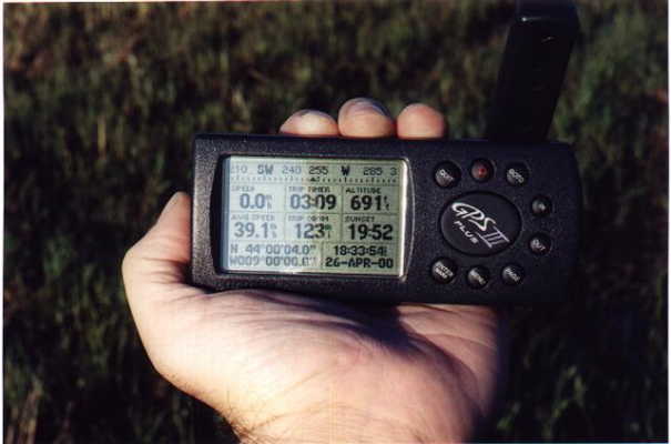
| #1: One of the clearer photos of the confluence area, facing northeast. #2: Panoramic mosaic view from confluence. #3: Tom at the confluence before sunrise. #4: Diagram on aerial photo showing our approximate route in and where Daniel Klein says he stopped. #5: USGS map segment erroneously showing "non-marsh" on the west side of the irrigation ditch. Confluence is red '+' sign. #6: GPS at the confluence, 4:58 a.m. ALL: All pictures on one page |