|

Italy : Calabria
2.9 km (1.8 miles) W of Staiti, Reggio di Calabria, Calabria, Italy
Approx. altitude: 820 m
(2690 ft)
([?] maps: Google MapQuest OpenStreetMap ConfluenceNavigator)
Antipode: 38°S 164°W
Accuracy: 3 m (9 ft)
Quality: good
Click on any of the images for the full-sized picture.


![]()
| 38°N 16°E (visit #1) |
![Visit #2: [15-Oct-22]](/it/all/n38e016v2/preview.jpg "Visit #2: [15-Oct-22]")

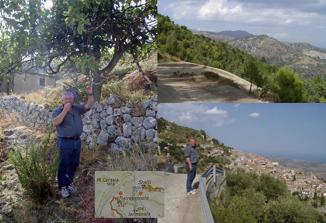
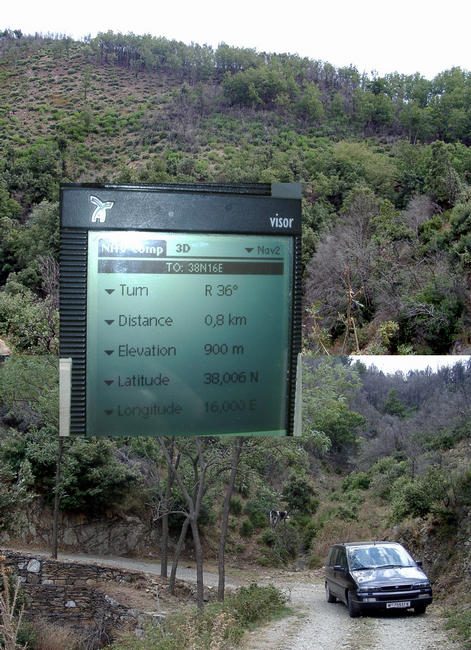
(visited by Hans Augdoppler, Gerhard Reithner and Helmut Heigl) 07-Oct-2001 -- On 15-September-2001 we decided to go for the Calabrian confluences. We were not able to convince Captain Peter to join us from Sicily. We started the exploration from the village of Pietrapenata. On our way up from Palizzi Marina we passed Pailizzi and we had a fantastic view back to the Ionian Sea as well as towards NW, the village of Bova. From the available maps we knew that this CP wouldn’t be an easy one. It supposed to situated on the slopes of Monte Cerasia (~1013m). We parked at the graveyard of Pietrapenata and began our walk towards the CP from a remaining distance of ~1.4 km. Soon we came as close as ~400m while crossing a creek. But from there on the distance increased again while we followed the footpath. A few attempts to leave the path ended up either in dense thorn bushes or were blocked by almost vertical rock walls. Burnt by the pitiless Mediterranean sun we decided to return to the car. From there we had a better view at the suspected location. The upper part of Monte Cerasia seemed to be cultivated and not covered with these dense bushes. So we tried to find the road to the next village, named Staiti. This is a real interesting road, mainly gravel, which is adapted to this very steep landscape and consists of numberless serpentines. We passed a tree with ripe figs and we had to taste it. When we arrived at the cemetery of Staiti we turned left and followed a gravel road up towards the northern slope of Monte Cerasia massif. We continued until we finally reached 16°E at an altitude of 900 m. Still 800m to go south but the terrain looked much more inevitable even we could observe grazing cattle. Nevertheless it was too late to launch another attempt, but this discovery is important for the next attempt by us or somebody else. Coming from Sicily on 07-October-2001 I was eager to finalize the previous attempt. Unfortunately Captain Peter had to go to Rome on this day and therefore was not able to join me. While heading along the SS106 towards Brancaleone Marina I passed the confluence in a distance of less than 9 km. This means that the Monte Cerasia is just 9 km away from the Ionian Sea. First I had to drive up to Staiti from Brancaleone Marina, a drive surrounded by a peculiar landscape. Staiti itself is not so easy to pass with a car, so I ended up at a dead end once. Somehow I found the mountain road again and I made this interesting journey the 2nd time. Now I knew that it does not end suddenly and is in a drivable condition. Again I parked the car at 16°E and dressed myself properly in order to withstand rough mountainous conditions and thorn bushes. More or less I followed the exact longitude and I was able to use cattle tracks. From Luca Bartolini I’ve received a satellite image, which helped me a lot – Thanks to him. As I crossed the ridge I saw that this attempt could be successful. Grazing cattle crossed my route looking at the strange creature. Old oaks, some of them burnt, ferns and also some thorn bushes I passed on my way down. Just at the CP the thorn bushes became denser and I had some difficulties to locate the exact ZERO position. I had a good view towards the route we made during our previous attempt. Finally I marked the position and shot some panoramic photos. Even this October day was very hot (~35°C) and therefore the sight was not as good. Additionally I’ve planned to visit the peak of the Monte Cerasia. Another 200 m of walking in a steep terrain under the blistering sun of South Italy. On the peak I found a geodetic mark dated from 1935. Actually I was not able to find out whether cattle already visited this peak. Of course human beings were there, you may see their footprints and some things that were left behind. Taking advantage of my heavy-duty outfit I was now able to choose the direct way to the car. Crossing steep gravel fields and distributed thorn bushes was not a real challenge. Completely wet, but happy I changed my dress and enjoyed the air conditioning in the car. At the top of Staiti I decided not to return on the same road into the village. I took an alternative way, as I thought. But this was a real mistake. The alley became very narrow and finally I got stuck somewhere in the center of Staiti. This was a real disaster. I had to turn the car having just less than half a meter of space. When I had managed this problem I learned that the way back can be sometimes more difficult, even with a car. Reversing numberless times while proceeding only for centimeters. With the assistance of a villager I escaped with two brand new scratches. This situation was perfect for a photo, but I was not in mind of doing this. Now I headed towards Cutro, to 39°N17°E, with the lost time pressing me. On Sunday afternoon the roads are crowded with people enjoying the life rather than driving. Italian Version (translated & interpreted as courtesy by Maria Fedele) 07-Oct-2001 -- 15 Settembre 2001 abbiamo deciso di dirigersi verso le confluenze calabresi. Non siamo riusciti purtroppo a convincere Capitano Peter ad unirsi a noi dalla Sicilia; abbiamo iniziato l’esplorazione dal paese di Pietrapenata. Attraverso il nostro percorso, siamo passati da Palizzi Marina a Pailizzi e abbiamo goduto di una fantastica vista del Mar Ionio e attraverso NW, del paese di Bova. Dalle mappe in nostro possesso, già sapevamo che questo CP non sarebbe stato uno dei più semplici. Ipotizzavamo potesse trovarsi in qualche pendio del Monte Cerasia (~1013m). Abbiamo parcheggiato in prossimità del cimitero di Pietrapenata e abbiamo iniziato la nostra marcia verso il CP localizzato ad una presunta distanza di ~1.4 km. Quasi subito, nell’attraversare un’insenatura, ci siamo trovati ad una distanza dal CP di soli ~400m; ma, da quel momento in poi, seguendo il percorso pedonale, la distanza è aumentata. I diversi tentativi di abbandonare il percorso sono terminati in compatti cespugli spinosi o di fronte a pareti rocciose. Ormai arsi dall’impietoso sole mediterraneo, abbiamo deciso di tornare all’auto. Da qui potevamo usufruire di una vista migliore del luogo “sospetto”. La cima del Monte Cerasia appariva coltivata e non coperta dai cespugli compatti; abbiamo, quindi, deciso di provare a trovare la strada per il paese successivo, Staiti. La strada si è rivelata veramente interessante, per lo più ghiaiosa, assolutamente adatta, con le sue innumerevoli serpentine, a questo erto paesaggio. Passando di fronte ad un albero con fichi maturi, abbiamo proprio dovuto assaggiarli. Arrivati al cimitero di Staiti, abbiamo girato a sinistra ed abbiamo seguito una stradina in ghiaia per risalire la scarpata nord del Monte Cerasia fino a raggiungere 16°E ad un’altitudine di 900 m. Dopo altri 800m verso sud, pur potendo osservare un pascolo bovino, diventava sempre più difficile seguire il sentiero ed evitare la terra. Era ormai troppo tardi per provarci ancora, ma almeno, questa scoperta sarebbe potuta essere utile per il prossimo tentativo da parte nostra o di qualcun altro. Tornando dalla Sicilia il 7 ottobre 2001, ero ansioso di portare a compimento l’impresa sospesa la volta precedente. Purtroppo il Capitano Peter non aveva potuto accompagnarmi poiché era dovuto andare a Roma. Mentre ero sulla SS106 verso Brancaleone Marina, la confluenza distava meno di 9 km; pertanto Monte Cerasia dista esattamente 9 km dal Mar Ionio. Ho guidato su verso Staiti da Brancaleone Marina, circondato da un panorama particolare, speciale. Non è semplice attraversare Staiti con l’auto; sono, infatti, finito in un vicolo cieco prima di ritrovare in qualche modo la stradina di montagna e di ricominciare questa interessante avventura per la seconda volta, accorgendomi che la strada in realtà non finisce improvvisamente ed è transitabile. Ho nuovamente parcheggiato a 16°E ed ho indossato abiti adatti per affrontare la montagna “selvaggia” ed i cespugli spinosi. Ho più o meno seguito l’esatta longitudine percorrendo i sentieri del bestiame. Ho ricevuto da Luca Bartolini, che ringrazio, un’immagine satellitare che mi è stata molto utile. Appena attraversata la cima, mi sono reso conto che questo tentativo avrebbe potuto avere successo. Un pascolo che attraversava sul mio percorso osservava la strana creatura che gli si poneva di fronte. Ho incontrato sul mio cammino vecchie querce, alcune bruciate, felci e cespugli spinosi. Proprio al CP, i cespugli spinosi si sono fatti più compatti ed ho trovato difficoltà ad individuare l’esatta posizione ZERO. Finalmente ho tracciato la posizione ed ho scattato alcune foto panoramiche. Questa giornata di ottobre era particolarmente calda (~35°C) e perciò la vista non era delle migliori. Avevo inoltre programmato di visitare la cima del Monte Cerasia. Altri 200 m di cammino su un terreno scosceso sotto il sole cocente dell’Italia meridionale. Sulla cima ho trovato un’indicazione geodetica datata 1935. Non sono in grado di dire se un pascolo abbia mai visitato questa cima. Naturalmente ci sono stati esseri umani, sono visibili le loro impronte e quello che si sono lasciati dietro. Avvantaggiandomi del mio pesante “equipaggiamento” ho potuto scegliere una via diretta per raggiungere l’automobile. Attraversare i campi ghiaiosi in pendenza ed i vari cespugli spinosi non è stata una vera e propria sfida. Completamente bagnato ma soddisfatto ho cambiato gli abiti e mi sono goduto l’aria condizionata dell’auto. Dall’alto di Staiti ho deciso di non riprendere la stessa strada per il paese ma di provare quella che pensavo essere una via alternativa. E’ stato un vero errore. Il vicolo è diventato sempre più stretto ed infine mi sono infilato da qualche parte nel centro di Staiti. Un vero disastro!. Ho dovuto fare inversione di marcia avendo a disposizione meno di mezzo metro di spazio. Dopo aver gestito questo problema, ho dovuto anche imparare che a volte la via di ritorno può essere più difficoltosa persino in auto. Avanti ed indietro, innumerevoli volte, procedendo solo di pochi centimetri. Con l’aiuto di un abitante del villaggio, sono riuscito a fuggire non senza due nuovi graffi. Sarebbe stata una situazione perfetta per una foto, peccato non ne fossi in vena! Guidavo verso Cutro, a 39°N17°E, sotto pressione per il tempo perso. La domenica pomeriggio le strade sono affollate di persone vogliose di godersi la vita piuttosto che di guidare. |
| All pictures |
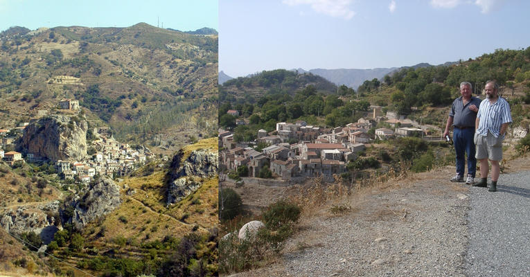
| #1: Massif of Monte Cerasia with CP indicated / Monte Cerasia con CP indicato #2: Creek close to CP with impassible access route / Insenatura vicina al CP con accesso impossibile #3: Palizzi & Pietrapenata #4: Road to Staiti with fig tree and map / Strada per Staiti con albero di fico e mappa #5: Starting from the north / Partenza da nord #6: Confluence with view to south & north and GPS reading / Confluenza con vista a sud & nord e lettura GPS #7: Mt. Cerasia – view to east & panorama to north / Mt. Cerasia - vista ad est & panorama a nord #8: From Palizzi Marina to Palizzi towards Ionian sea / Da Palizzi Marina a Palizzi verso il Mar Ionio #9: NE to Palizzi & Pietrapenata with Mt. Cerasia / NE a Palizzi & Pietrapenata con Mt. Cerasia #10: Panorama from Mt. Cerasia (NE to S) / Panorama da Mt. Cerasia (NE a S) ALL: All pictures on one page |
| Notes |
|
Near the southeastern edge of the Parco Nazionale dell'Aspromonte. |