|

France : Centre-Val de Loire
3.1 km (1.9 miles) NW of La Chapelle-Vicomtesse, Loir-et-Cher, Centre-Val de Loire, France
Approx. altitude: 176 m
(577 ft)
([?] maps: Google MapQuest OpenStreetMap ConfluenceNavigator)
Antipode: 48°S 179°W
Accuracy: 3 m (9 ft)
Quality: good
Click on any of the images for the full-sized picture.


| 48°N 1°E (visit #1) |
![Visit #6: [07-Jun-22]](/fr/all/n48e001v6/preview.jpg "Visit #6: [07-Jun-22]")
![Visit #5: [30-Dec-17]](/fr/all/n48e001v5/preview.jpg "Visit #5: [30-Dec-17]")
![Visit #4: [04-Sep-16]](/fr/all/n48e001v4/preview.jpg "Visit #4: [04-Sep-16]")
![Visit #3: [09-Sep-09]](/fr/all/n48e001v3/preview.jpg "Visit #3: [09-Sep-09]")
![Visit #2: [31-Dec-06]](/fr/all/n48e001v2/preview.jpg "Visit #2: [31-Dec-06]")

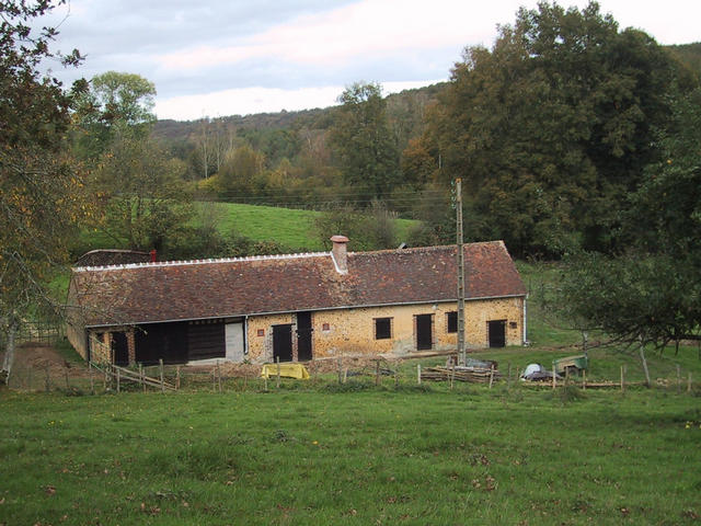
(visited by Michel Dupuis and Anne Marie Dupuis) 31-Oct-2001 -- Coming from Paris, we left the highway A11 at Luigny, and proceeded south to La Bazoche Gouet, Le Gault du Perche and Saint Agil, then south-east to Boursay, using the D40. From there we took the small road to "Le grand Bouchet" and there, left to "Les Bailliveries" where we had to leave the car, as it was forbidden to go further if motorised! Leaving the car 680 meters from the confluence (N47° 59.92 E000°59.52), we then followed a sunken road among hedges and meadows on the south side of the Grenne brook. The road terminates at a small old restored farm and the end of the way to the confluence had to be done through steep meadows and across hedges. The spot is 193 meters high in an open area with cows in the distance. |
| All pictures |
| #1: View to the spot arriving from south west #2: Les Bailliveries, 680 meters from the spot #3: 100 meters west of the spot #4: view east from the spot #5: view west from the spot #6: the GPS view #7: the track we walked from the car to the confluence point ALL: All pictures on one page |