|

United Kingdom : England
3.3 km (2.0 miles) E of York-Earswick, York, England, United Kingdom
Approx. altitude: 16 m
(52 ft)
([?] maps: Google MapQuest OpenStreetMap ConfluenceNavigator)
Antipode: 54°S 179°E
Accuracy: 6 m (19 ft)
Quality: good
Click on any of the images for the full-sized picture.


| 54°N 1°W (visit #2) |
![Visit #21: [27-Oct-21]](/uk/en/n54w001v21/preview.jpg "Visit #21: [27-Oct-21]")
![Visit #20: [03-Jan-20]](/uk/en/n54w001v20/preview.jpg "Visit #20: [03-Jan-20]")
![Visit #22: [05-Sep-19]](/uk/en/n54w001v22/preview.jpg "Visit #22: [05-Sep-19]")
![Visit #19: [26-Jun-14]](/uk/en/n54w001v19/preview.jpg "Visit #19: [26-Jun-14]")
![Visit #18: [09-Sep-10]](/uk/en/n54w001v18/preview.jpg "Visit #18: [09-Sep-10]")
![Visit #17: [19-Aug-10]](/uk/en/n54w001v17/preview.jpg "Visit #17: [19-Aug-10]")
![Visit #16: [24-Jun-10]](/uk/en/n54w001v16/preview.jpg "Visit #16: [24-Jun-10]")
![Visit #15: [24-Jun-10]](/uk/en/n54w001v15/preview.jpg "Visit #15: [24-Jun-10]")
![Visit #14: [23-Apr-10]](/uk/en/n54w001v14/preview.jpg "Visit #14: [23-Apr-10]")
![Visit #13: [16-Apr-10]](/uk/en/n54w001v13/preview.jpg "Visit #13: [16-Apr-10]")
![Visit #12: [12-Sep-09]](/uk/en/n54w001v12/preview.jpg "Visit #12: [12-Sep-09]")
![Visit #11: [29-May-09]](/uk/en/n54w001v11/preview.jpg "Visit #11: [29-May-09]")
![Visit #10: [29-May-09]](/uk/en/n54w001v10/preview.jpg "Visit #10: [29-May-09]")
![Visit #9: [21-May-09]](/uk/en/n54w001v9/preview.jpg "Visit #9: [21-May-09]")
![Visit #8: [11-Jan-09]](/uk/en/n54w001v8/preview.jpg "Visit #8: [11-Jan-09]")
![Visit #7: [30-Nov-08]](/uk/en/n54w001v7/preview.jpg "Visit #7: [30-Nov-08]")
![Visit #5: [14-Jul-08]](/uk/en/n54w001v5/preview.jpg "Visit #5: [14-Jul-08]")
![Visit #6: [14-Jul-08]](/uk/en/n54w001v6/preview.jpg "Visit #6: [14-Jul-08]")
![Visit #4: [08-Jun-08]](/uk/en/n54w001v4/preview.jpg "Visit #4: [08-Jun-08]")
![Visit #1: [25-Aug-01]](/uk/en/n54w001/preview.jpg "Visit #1: [25-Aug-01]")
![Visit #3: [06-Nov-07]](/uk/en/n54w001v3/preview.jpg "Visit #3: [06-Nov-07]")

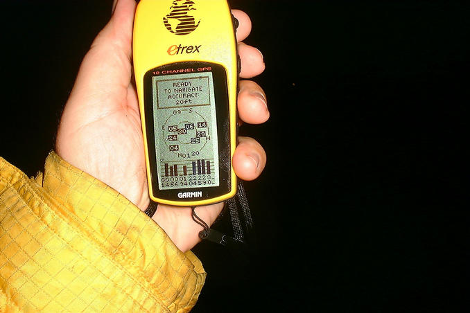
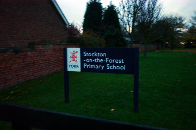
(visited by Gordon Spence) 23-Nov-2001 -- Here we go again, I am on a course in Wakefield, North Yorkshire (Cisco BSCN if you are wondering) and it looks like we will finish just after lunch on Friday. The nearest point to the course is NE of York, about 25 miles away as the proverbial crow flies. I checked an on-line route planner and it returned 33 miles, now the days are short round here at this time of year and sunset according to the GPS was 3.56pm. Should be plenty of time to get there before it gets dark. It was quite an uneventful run up the M1/A1M/A64 until I hit those roadworks, they are doing improvements worth £4.1M, but it is taking 60 weeks!, nearby to where I live they are doing a £56M improvment that is going to take 40....traffic was backed up for a mile. Once through it I soon reached the village of Stockton on the Forest. First pass through the village took me to exactly 1W but about 1/4 mile too far South. Through the village and turn left down a single track road, I soon reached 54N but about 1/4 mile too far East! Back to the main road and ask at a candidate house, ostensibly the field was owned by Mr Parker, but when I tried him he said "no lad, try them over there" pointing to a nice house about 1/2 a mile away. Into the car and back to that house. I explained my task to a lovely couple who pointed out that I had parked my car on what was the main railway line up until 1965, when about 40% of the rail network was closed. Their house was ex railway property and came with 3 acres of land. Anyhow, it wasn't their field either! I was pointed to a house in the village (Mr Wilson), tried there wasn't his but he said try Church Farm. I asked how far and he smiled, turned and pointed about 50 yards over the road. I knocked and explained again what I was doing (geeting to know the speech by now!) and permission was given to wander. Success. It was by this time beginning to get towards dusk and I still had a 200 mile drive home. Off into the fields, it looked like winter crops may have been planted, so I get to the outside edges. Three fields later...I reach the spot. Sorry it is a bit blurred but there wasn't much light. I switched to the sattelite display and locked onto eight, accuracy reported as 20 feet. Turning to face North, you can see that it is getting dark (the sun set about 15 minutes previously). As I set off I tried a location GPS shot with flash (camera battery running low now), this time off by 0.1 seconds. I took the direct route back and passed behind a school playing field with football practice just finishing. I wonder if the school know they are so close? The front gate is at 53:59:47.8N 0:59:59.5W |
| All pictures |
| #1: Location shot looking North #2: On the exact spot #3: Accuracy #4: Off by a few feet #5: It's just behind this school ALL: All pictures on one page |