|

China : Guǎngdōng Shěng
11.5 km (7.1 miles) ENE of Wushan (Húnán), Guǎngdōng, China
Approx. altitude: 995 m
(3264 ft)
([?] maps: Google MapQuest OpenStreetMap ConfluenceNavigator)
Antipode: 25°S 67°W
Accuracy: 750 m (820 yd)
Quality: good
Click on any of the images for the full-sized picture.


")


| 25°N 113°E (visit #1) | (incomplete) |
![Visit #2: [31-Mar-02]](/cn/all/n25e113v2/preview.jpg "Visit #2: [31-Mar-02]")

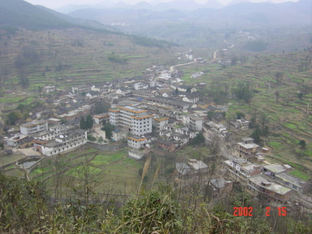
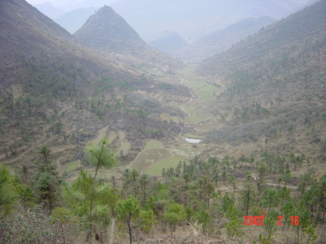
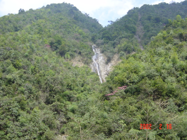
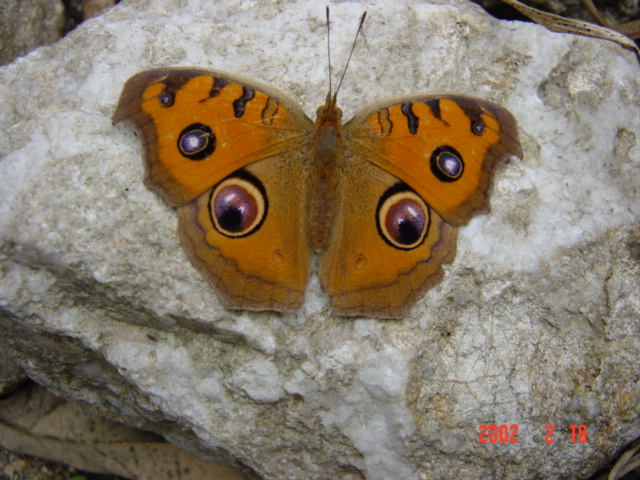
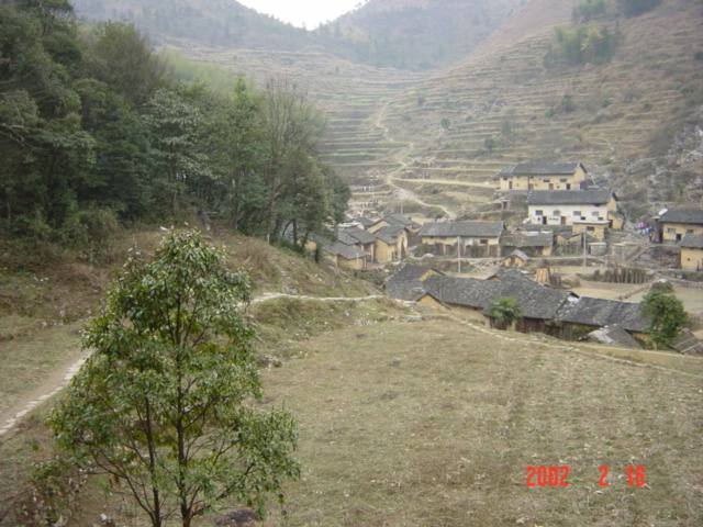
(visited by Targ Parsons) 16-Feb-2002 -- This story continues from 25°N 114°E. THURSDAY 14 FEBRUARY 2002. This confluence is located in rugged mountainous country in the north of Guangdong province. According to the map, there is a main road that actually lies only four kilometres to the south of the confluence at its closest point, however I suspect this may as well be 40 or 400 kilometres, given the terrain. Instead, the only viable approach seemed to be from the north. After studying the network of roads and rail lines in this part of Guangdong province, I determined that my first objective would need to be Pingshi, thirty-some kilometres to the north of the confluence. As I was sitting in the comfort of my hotel room in Shaoguan, working out the above plan of attack, I was also watching the news on one of the English-language Hong Kong TV stations. The lead news item for the night concerned a recent spate of fatal bus crashes in southern China involving Hong Kong tourists. Perhaps it was this that influenced my decision to take the train to Pingshi instead of the bus. I went downstairs and inquired at the hotel business centre about trains north to Pingshi, and booked a ticket on the 10:32 a.m. train for the next morning. FRIDAY 15 FEBRUARY 2002. Well, I thought I'd booked a ticket, but when I checked with the business centre again in the morning, it turned out that that particular train didn't even exist any more, and the first scheduled train that would stop in Pingshi was not due to leave Shaoguan until early that afternoon, plus it was a relatively slow train to boot. So it was back to the buses! I very reluctantly checked out of the lavish comfort of my hotel room at the President Resort, took a taxi to the bus station where the girl in the business centre had told me I could get a bus to Pingshi, and was on a bus bound for Lianzhou (which would go past Pingshi) by 9:20 a.m. Perhaps because of the recent poor bus safety record, the bus was subjected to a police check just as we were leaving the outskirts of Shaoguan. Apparently we were overloaded, and several passengers had to be coaxed to disembark. There then proceeded to be a long wait while the driver and conductor negotiated with the police at their roadside desk. From my vantage-point at the rear of the bus, I could see much paperwork changing hands; I think they were being fined. Eventually we were on our way again, however not for long. Only a few hundred metres down the road from the police checkpoint, we pulled over, and waited for the disenfranchised passengers to cover the distance on foot and reboard! To top it all off -- if the situation weren't already sufficiently farcical -- we continued to pick up anyone else who happened to wave the bus down as we continued on our way. Soon the aisle was absolutely chock-a-block with people and luggage. We drove through very mountainous terrain, the bus labouring up each slope (with its extra-heavy load), then careening down the other side. Where the land was flat enough to permit cultivation, some of it was devoted to rape, which was just coming into bloom, and the bright yellow flowers made a very pretty contrast to the rest of the landscape. The bus took an altogether unexpected route from Shaoguan to Pingshi, completely different from what I had anticipated. However, this turned out to be a good thing, because I could now get out at what was to have been my second milestone of the day, Meihua, without having to go to Pingshi at all. Meihua is 23 kilometres north of the confluence. I managed to disembark there at 11:50 a.m., after first clambering over, around and through the mass of humanity and belongings clogging the aisle. Within a quarter of an hour, I was on board a small utility converted to passenger use, heading to my next destination, the small town of Shaping (pronounced "shah-ping") just 10 kilometres north of the confluence. I arrived in Shaping at 12:45 p.m. After some questioning of the locals, I located the town's only guesthouse. The guesthouse owner was a dwarfish fellow, very friendly and jovial, who insisted that I eat lunch with him (no charge) before showing me to my room. Over the course of lunch, we were joined by a number of curious locals. I explained why I was there, and although the concept of confluences went pretty much over everyone's head, I was still able to gather some valuable intelligence about the remote area where the confluence was located. The maps I had offered only very scant details. It was at about this time that someone suggested to the guesthouse owner that I ought to register with the police before being accepted as a lodger. Having had to do this a few days earlier in another relatively small town, I considered it a simple formality, and wasn't all that concerned. I left my backpack in the room, then walked down to the local police station. When I first got there, the entire police station complex was completely deserted, everyone apparently at lunch. Then a young lad came up to me speaking English, and within a short while had managed to find a police officer, who came and opened up the main police building. Not long after, a second officer joined him. Although they both seemed like they genuinely wanted to help me, and were treating me quite congenially, I don't think they really knew quite what to make of a foreigner showing up on their home turf. I could sense that things were beginning to go a little pear-shaped. And all the while, valuable daylight hours were relentlessly frittering away. After no real progress had been made regarding my registration for nearly an hour, a more senior official materialised. After a briefing from the other two, and some more discussion, a decision was finally made: We had to summon someone else with even higher authority to make the decision! Cell-phones were brought into play to summon said person of authority, and I was informed that he would not be able to attend for several hours, and it was suggested that I could wait in my room at the guesthouse. That sounded positively boring, so I asked if I might at least be allowed to wander around Shaping during the period of interminable waiting. Discussions were held with the young English-speaking lad, and I was then entrusted into his care. Thank goodness I wasn't incarcerated in my guesthouse room! There was a hill next to the town, and James (the lad's English name) accompanied me as I climbed up to get a good overall view, and to take some pictures (picture #2). The police compound is the large collection of white buildings with yellow-trimmed roofs in the foreground. We were supposed to be waiting for the police to call James on his mobile phone to announce the arrival of the decision-maker, but I decided to wander back anyway to check on progress. The decision-maker was approaching the station compound just as I was, and had obviously already been well-briefed on the situation, because he knew who I was, and immediately walked up to me to extend a warm welcome to Shaping. I began to think things were going to work out, but then, in practically the very next breath, he suggested that I collect my things, and go and stay the night in faraway Pingshi! He apologised, saying that it was really all in my own best interests, because my safety couldn't be guaranteed. He also said that, if I were to come back in 11 days' time, my case could be reviewed, because by that time, someone even higher up the pecking order would be back from Chinese New Year holidays, and that that person may be willing to take on the responsibility. There was no point arguing. With a sincere sense of disappointment, borne mainly out of the realisation that there was to be no chance for even a single confluence visit this day (on every previous day I'd completed one, if not two), I returned to the guesthouse and picked up my backpack. I tried to offer the understanding owner at least something for the lunch he'd given me, but he wouldn't hear of it. I hopped into a passenger-ute heading back to Meihua, and sat thinking the whole way of what to do next. By the time I reached Meihua, I had adapted my plans to cater to the new set of circumstances. Instead of continuing on to Pingshi as suggested, I'd stay the night in Meihua, then make an early morning assault on the confluence from there. As I wandered around the streets of Meihua looking for a place to stay, a teenage girl approached me wanting to practice her English. Her level of English was actually surprisingly good, so I pretended I couldn't speak Chinese, and let her help me find a guesthouse. Once that was accomplished, she invited me back to her aunt's place for dinner, where there was the usual huge extended family gathering. Among this lot were two guys, one of whom said he'd always wanted to visit the area where the confluence was located because of its scenic beauty, and the other who was inspired by the crazy idea of hunting down the confluence itself. The three of us agreed to meet at 8 a.m. the next morning, and ride out there on their motorbikes. SATURDAY 16 FEBRUARY 2002. By morning, our numbers had swollen from three to five. But there were only two motorbikes, so we negotiated hiring another one for the day. The hired bike came together with its rider, so now we were six. We were finally on our way at 8:30 a.m. The road from Meihua to Shaping is very good, paved all the way, and by 9:10 a.m. we were making our way through Shaping, where we did not linger, lest the local constabulary were once more on the lookout for foreigners whose safety could not be guaranteed. From Shaping onwards, there was only a dirt road, and this soon deteriorated into a rocky track that switched back and forth up into the mountains. But the scenery was truly spectacular. Picture #3 simply does not do the magnificent landscape justice. The majestic scale is difficult to visualise from the photo; it really needs to be experienced first-hand. The persistent haze doesn't help much either, obscuring quite a lot in the photo that was otherwise visible to the naked eye. We were following a track leading towards the Babaoshan forestry camp, three kilometres southeast of the confluence. During my time in Shaping the day before, I had learned of another disused track, not marked on my map, which was supposed to go from Babaoshan along a river valley, first south and then west of the confluence, eventually finishing up at the Rongjiadong forestry camp 3.5 kilometres northwest. (To save myself from continually repeating "...of the confluence," readers can from now on safely assume that all distances and directions quoted are in respect of the confluence.) We found the turn-off to this unmarked track without any problem, and were able to follow it until we were two kilometres south. At this point it ended, replaced by a narrow trail navigable only on foot. We parked the bikes and continued along the trail. The trail followed a river down a deep narrow gorge for some distance, then suddenly became a disused vehicular track again, at the site of some abandoned buildings. As it wound its way along the ravine on the south side of the river, we eventually came to a point where we were "only" 750 metres southwest (picture #4). In front of us, on the opposite bank of the river, was a very steep mountain with a spectacular waterfall (picture #1). When you look at this photo, bear in mind that we were in the bottom of a ravine, and the camera was facing up at a sharp angle; it was not taken simply looking horizontally. You will then realise why we considered it unclimbable without the assistance of an experienced mountaineer, equipped with ropes and all the rest of the proper gear. We continued on in the direction of Rongjiadong, hoping for a promising turn, or for a strategic hidden valley to be revealed, but only succeeded in getting further away. We stopped when we were 1.4 kilometres due west. The mountains were not quite as steep here, but we decided that climbing them was out of the question. For one thing, an ascent would involve considerable time and effort, and without the proper gear, there was no guarantee of success. And for another thing, even after scaling the first mountain, we would probably still be no more than 100 metres closer to our goal, and no telling what obstacles still lay in between. There simply wasn't sufficient time. Besides, we'd left half our party back at the abandoned buildings. So we turned around and started heading back. The total absence of humanity meant there was plenty of birdlife, and at one point we saw a large tree filled with beautiful birds sporting spectacularly long tails. I don't know what species they were though. Further along we encountered a stunning butterfly sunning itself on a rock in the middle of the path (picture #5). We found the other three of our party near where we'd left the bikes. They in turn had found a local peasant, who had set up a shelter nearby to store firewood he was collecting. Resplendent in his trendy Playboy shirt and with his captivating smile (picture #6), he cooked us all a very hearty lunch of pork, vegetables and rice. We discussed the problem of reaching the confluence with the Playboy peasant, and he told us about his own village, which was not marked on the map, but which I remembered we'd passed on the road to Babaoshan. It was exactly three kilometres due east. He said that there was a trail going up from his village to another village called Yanggouliao. Yanggouliao does in fact feature on my map, and is 1.5 kilometres north-northeast. I believe it may offer a possible approach from that direction. Later, on our way back, we stopped at Playboy's village, and indeed saw the trail to which he was referring (picture #8). For anyone making a subsequent attempt at this confluence (and I highly recommend it, if only for the breathtaking scenery), then I suggest trying this approach first. A second alternative is a track we discovered heading off from the main track about 3.5 kilometres northeast (picture #9). It's not marked on my map, but I suspect it may make its way around to the northwest, eventually linking up with the disused track we followed that got us to within 750 metres. In so doing, it may offer other possible inroads to the confluence from the northwest. The third option is the brute force approach: take some climbing gear and start off from the point 750 metres southwest. By the time we got back to Meihua, it was already early evening. There I was, way up in the north of Guangdong province, and I needed to be back at work in Hong Kong on Monday morning, in 36 hours' time. I declined an offer for another home-cooked meal, and instead headed up to Pingshi, from where I was able to catch an overnight train back to Shenzhen. It had been a great adventure, blessed with absolutely perfect weather throughout, and although the final result saw only eight of the 12 planned confluences conquered (picture #10), I had nonetheless thoroughly enjoyed myself. Without doubt, the best part of the whole trip had been the failed attempt at this ninth confluence, and I have every intention of giving it another go one day, when I have unlimited time to spare. Nothing gets me going more than a good challenge! |
| All pictures |
| #1: The confluence is 750 metres beyond #2: The picturesque town of Shaping #3: Spectacular country...pity about the haze though #4: As close as we got...this time #5: The eyes have it #6: The peasant who made lunch for us (I wonder if HH got his royalties for this shirt?) #7: The gang of six #8: This path going off up into the mountains is the best bet for another attempt #9: Another possible approach is the track disappearing over the top of the hill at the top left of this photo #10: The final result: eight successes, one attempt ALL: All pictures on one page |