|

United Kingdom : England
near Michaelchurch Escley, Herefordshire, England, United Kingdom
Approx. altitude: 229 m
(751 ft)
([?] maps: Google MapQuest OpenStreetMap ConfluenceNavigator)
Antipode: 52°S 177°E
Accuracy: 5 m (16 ft)
Quality: good
Click on any of the images for the full-sized picture.


| 52°N 3°W (visit #2) |
![Visit #12: [27-Sep-19]](/uk/en/n52w003v12/preview.jpg "Visit #12: [27-Sep-19]")
![Visit #11: [26-Jun-22]](/uk/en/n52w003v11/preview.jpg "Visit #11: [26-Jun-22]")
![Visit #10: [23-Dec-15]](/uk/en/n52w003v10/preview.jpg "Visit #10: [23-Dec-15]")
![Visit #9: [31-Aug-14]](/uk/en/n52w003v9/preview.jpg "Visit #9: [31-Aug-14]")
![Visit #8: [11-Aug-10]](/uk/en/n52w003v8/preview.jpg "Visit #8: [11-Aug-10]")
![Visit #7: [04-Jun-06]](/uk/en/n52w003v7/preview.jpg "Visit #7: [04-Jun-06]")
![Visit #6: [01-Apr-06]](/uk/en/n52w003v6/preview.jpg "Visit #6: [01-Apr-06]")
![Visit #5: [30-Oct-04]](/uk/en/n52w003v5/preview.jpg "Visit #5: [30-Oct-04]")
![Visit #4: [02-May-04]](/uk/en/n52w003v4/preview.jpg "Visit #4: [02-May-04]")
![Visit #3: [31-Jan-04]](/uk/en/n52w003v3/preview.jpg "Visit #3: [31-Jan-04]")
![Visit #1: [22-Jul-01]](/uk/en/n52w003/preview.jpg "Visit #1: [22-Jul-01]")

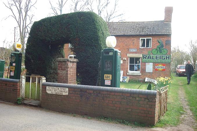
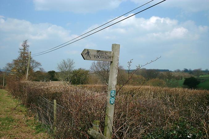
(visited by Gordon Spence, Craig Spence and Nicola Spence) 30-Mar-2002 -- Right then, visit my children time so that also means it is confluence time again. The only problem is they are getting further and further away.... I decided on 52N 3W today, the last point in England on 52N that I haven't visited yet. I left home at 7.30am for the 95 mile drive to pick up Nicola and Craig, turn around then drive 125 miles SW to reach the confluence point. On the way I spotted what looked like a collection of old petrol (gas) pumps and shop signs. I had a chat with the owner (you can see him walking down his drive) who told me that it was still a fully operating service station! The pups in the picture had been there since the 50's when his father ran it. Before that when his grandfather ran it, there were hand-operated fuel bowsers... The interesting part though, is that the local authority fire service and the Health & Safety people tried to shut him down. The reason? it is "too near the road and a safety risk"...hmmm...it went to the High court in London, where the case was thrown out. Sometimes the little guy does win after all. A few miles further on and we drive through a tiny village and park up just past 52N, over the road is a "public footpath". Climbing the style there was no marked path at all, just some horses. It is not unusual for nothing to be marked, you often need a detailed Ordnance Survey (OS) map to see them marked. We set off in the general direction that the arrow was pointing in. This brought us to a gate (not locked) so we went through it. This is when it gets a bit interesting. Looking at the photo's from the previous visit, it appears that they were in fact in the wrong place. In their photo 2 you can see a large (Oak) tree in the right corner, that is in fact the actual spot. How do I know for sure?, we took a picture of the GPS held up against the trunk of it! I then clicked off the looking North shot, followed by the GPS shots and one of Nicola and Craig standing by the Oak tree. Time to go and get lunch and take Nicola and Craig home. Total daily mileage - around 450. Oh yes, one last thought, how did the tree know to grow on the exact spot? |
| All pictures |
| #1: Looking North #2: GPS montage #3: It's a working service station #4: Lucky break - walking allowed... #5: ..you have to share it though #6: Nicola & Craig on the spot #7: The tree *is* the confluence point! ALL: All pictures on one page |