|

Argentina : Buenos Aires
10.8 km (6.7 miles) NNE of Zárate, Buenos Aires, Argentina
Approx. altitude: 2 m
(6 ft)
([?] maps: Google MapQuest OpenStreetMap ConfluenceNavigator)
Antipode: 34°N 121°E
Accuracy: 3.0 km (1.9 mi)
Quality: good
Click on any of the images for the full-sized picture.


| 34°S 59°W (visit #1) | (incomplete) |
![Visit #2: [20-Jul-02]](/ar/all/s34w059v2/preview.jpg "Visit #2: [20-Jul-02]")

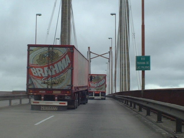
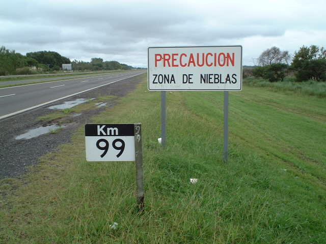
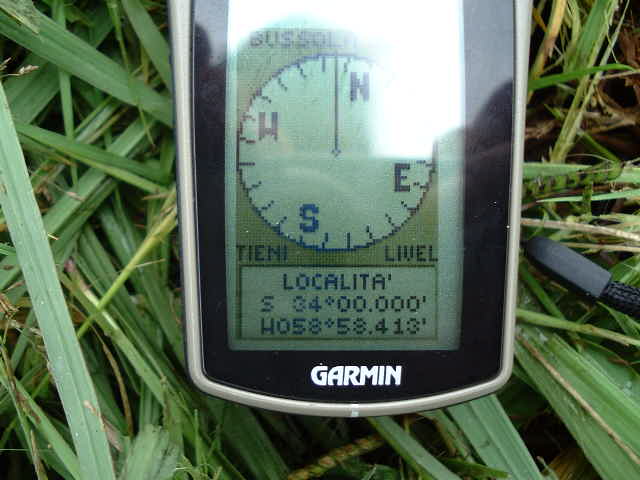
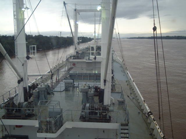
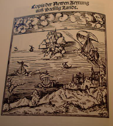
(visited by Captain Peter) 30-Mar-2002 -- Actually my ship is berthed at Campana, on the Rio Paraná, loading lemons for Russia. Close by there I found a point which I decided to visit. In the morning I walked from the Port to the Railway Station and found a cab. The driver, Mr Miguel, agreed on a fare of 30 Pesos (10 USD/11.40?). As everywhere in the world every overland taxi trip begins with refuelling. Then we started in direction Zárate. The road was in a surprisingly deplorable condition for such an industrialized region, and Miguel, having seen in his 66 years lifetime all the ups and downs of Argentina made no bones about the Government and the politicians filling only up their pockets and not doing anything for the benefit of the country. At Zárate we entered the Highway Route to Uruguay. Shortly after we crossed the suspension bridge over the Rio Paraná, built in 1977 under the Military Junta and named after one of the most famous early presidents of Argentina, Bartolomeu Mitre. At km99, shortly after the bridge in direction North we had reached 34°00'South. There I realized that my GPS showed still far in the East from the Confluence, almost 3 km (1.9 miles). We stopped but I saw no chance to proceed to the point without difficulties. There are a lot of private properties fenced in, and needless to say, dogs as well. As soon as I heared this famous inequivocable sound of dog's barking, for me the game was over and I rushed back to the taxi. The only thing I can enclose is a picture of the scenery there. All was very wet as it had been raining here since days. It is certainly possible to visit this point, but it has to be approached from another direction, not from the highway route. But we had no roadmap and time was pressing me, as I had still an appointment with a medical doctor. The Mouth of the Rio de La Plata and the Rio Paraná is closely linked with Magellan's voyage around the world. Magellan, after having left the Bay of Rio de Janeiro, arrived in this area on January 10th, 1520. He is searching for the "paso", the passage between the Atlantic Ocean and the Pacific he believes to be somewhere here, according to a publication from Germany. On the entrance to this mouth among the flat land they are sighting a small hill, 148m (485 ft) high, naming it "Montevideo" ("I see a mountain"). They continue sailing along the coast of this huge bay, etending obviously endlessly towards West. But this huge bay is in fact nothing else than the mouth of the Rio de La Plata. Magellan of course could not know that. He believes this to be the desired passage. Pigafetta, an Italian, who accompanied him as a reporter, wrote in his diary: "Si era creduto una volta esser questo un canal che mettesse nel Mar del Sur". (It has been believed this to be a canal leading into the South Sea). At the very beginning the scenery looked promising. With great satisfaction Magellan sees huge masses of water flowing towards West. But contrary to the tiny mouths of the European rivers, as the Rhine, the Ebro, the Tejo, where you always can see the shore on both sides, the mouth of the Rio de La Plata is uncomparably larger. Magellan sends the smaller ships to search for the assumed canal towards West (i.e. upstream of the River!). The two big ships are steering under his command across the bay towards South, "por si habia pasage", (in order to get the passage). But bitter disappointment! After fifteen days the smaller ships come back. Their masters bring a horrible message: What was believed to be the passage to the South Sea is nothing else than an extraordinary huge River with fresh water. For the really interested readers I enclose here an excerpt of the incorrect information which made believe Magellan the Mouth of the Rio de La Plata to be the "passage". It is a leaflet issued in 1507 in Augsburg (Germany), written by a certain Martin Behaim and containing the erroneous information that a Portuguese expedition in 1502/03 has allegedly used this passage to reach the South Sea. The name of the publication is: "Copia der Newen Zeytung auß Bresillg Landt" ("Copy of the New Newspaper from Brazil") The original is with the "Bayerische Staatsbibliothek" in Munich. Original Text (in Old German): ... unnd da sie kommen sein von Capo de Bona Sperantza, an ein Spitz oder Ort so in das Meer geht, und noch ein Grad höher oder weyter, ... sind sie in solche Clima oder Gegent kommen, ... nemlich in Viertzig Grad hoch (!!!), haben sie das Bresill mit einem Capo funden. Un haben den selbigen Capo umbseylet, uñ auff der annderen Seyten auch die Landt gesehen ... als sie umb den Capo kommë seyn, ... do ist Ungewitter so groß worden, auch Windt gewesen, daß sie nicht weyter haben kunnen seylen. Do haben sie durch Tramontana, das ist Nort, wieder herumb auff die ander Seyten von Bresill müssen faren. Der Piloto, so mit diesem Schiff gefaren ist, ist mein fast güt Frewndt (!!!). Ist auch der brühmbtest so in der Konig von Portugal hat ... der sagt mir, das von solchigem Cabo de Bresill, uber 600 Meyl (!!!) gen Malacca nit sey ... vermaint auch in kurtzer Zeit durch solchigen Viagio von Lisibona gen Malaqua zufaren und wiederumb kumen von der andere Seyten (!!!) ... das dem Kunig von Portugal mit der Specerey ein große Hilff wird pringen ... Translation in modern English: ... coming from the Cape of Good Hope they reached another Cape extending into the sea, but still one degree higher or farther, ... they reached a climate or a region, ... i.e. on 40° latitude (!!!), and they found Brazil with its Southern Cape. And they sailed around this Cape and saw the shore on the other side ... when they had passed the Cape, ... the weather became so bad, and there was strong wind, too, that they could not proceed farther. Then they had to go again towards Tramontana, this means North, back to the other side of Brazil. The Pilot who was with them, is quite a good friend of mine (!!!) and the most famous the King of Portugal has ... he told me, that from this Cape of Brazil it is not more than 600 miles (!!!) to Malacca ... he believes that in fairly short time such a voyage from Lisbon to Malacca could be performed and come back from the nother side (!!!) ... this could be a great benefit for the King of Portugal in his trade with spices ... From this we learn that this expedition has been not in the La Plata Mouth, but really at Cape Hoorn (strong wind, bad weather). The problem not being able to proceed farther after having passed the Cape is a typical one for Cape Hoorn, as the wind there is almost always Northwest, and often for a period of many months. So no wonder they had to sail back towards Brazil on a northly course. 30-Mar-2002 -- Para mis numerosos amigos argentinos aqui la versión en castillano: Del momento mi navio está atracado en el Puerto de Campana, cargando limones para la Russia. No lejo he encontró un punto lo que he decidí de visitar. La mañana ibo hacia la estación de ferrocarril de Campana para un taxí. El chófer, Señor Miguel, se declaró de acuerdo con 30 Pesos (10 USD/11.40?). Cómo en todo el mundo cada viaje fuera de la ciudad inicia con tomar combustible. La carretera para Zárate estaba en una condición sorprendentmente deplorable para una región así industrializada, y Miguel, habendo visto todos los altos y bajos de la Argentina en sus 66 años de vida, no se risparmió de jurar sobre el Govierno y los políticos que están sólo llenandose las propios bolsillas y no hacendo nada para el beneficio del pueblo. A Zárate entrabamos en la autopista para el Uruguay. Poco después atravesamos el puente sobre el Río Paraná, construida en 1977 durante el tiempo de la Junta Militar y bautizada sigún un presidente célebre de la Argentina, Bartolomeu Mitre. A km99, poco después del puente en dirección Norte llegamos a 34°00'Sur. Aquí realizó qué mi GPS enseñaba una posición demasiada en el Este del punto de intersección, casi 3 km (1.9 miles). Paremos y yo no vidi ninguna posibilidad de irme adelante sin problemas. Aquí hay mucha propriedad privada con cercadas alrededor, y, no necesita decirlo, perros también! Tan pronto como yo escuchó este famoso y inecuivocable ruido de perros ladrandos, para mi el juega estaba terminado. Volví tan rapido como posibla al taxí. La unica cosa que puedo adjuntar es una foto de la región. Todo estaba muy mojado porqué estaba lluvando casi ininterumpidamente para las últimas tres días. Es ciertamente posible de visitar el punto, peró necesita aproximarse de una otra dirección y no de la autopista. Peró no tenimos una mapa y tenío un poco prisa, habiendo todavia de visitar mi medico. El Río de La Plata y el Río Paraná son también juntos con la historia del viaje de Magallanes en redondo el mundo. Magallanes, después de la sua zarpe de la Bahía de Rio de Janeiro llega in este zona el 10 de enero de 1520. Està buscando el "paso" entre el Atlántico y el Pacifico, lo que cree de hallarse en este región - siguiente una publicación alemana. En la entrada del Río de La Plata descubre un cerro pequeño a la costa llana, un cerro de 148m (485 piés) de altitud, y lo bautiza "Montevideo". Continua la navegación a lo largo de la costa de esta bahía ancha, que evidentemente se estiende infinitamente hacía Oeste. Peró este bahía, como sabemos, en verdad es le embocadura del Río de La Plata. Naturalmente Magallanes no lo puedo saber. Cree que sea el paso. Pigafetta, un Italiano que lo està acompañando cómo periodista, escribe en su diario: "Si era creduto una volta esser questo un canal che mettesse nel Mar del Sur". En el inicio la región pareceba muy prometedora. Con gran satisfactión Magallanes vede fluir grandes masas de agua hacía Oeste. Peró, contraria a las embocaduras pequeñas de los rios europeos, cómo por ejemplo el Reno, el Ebro, el Tajo, dónde se vede siempre la costa en ambos los lados, la embocadura del Rio de La Plata es incomparablamente más ancha. Magallanes manda adelante los navíos más pequeños para explorar el canal hacía Oeste. Los dos grandes navíos navegán sobre la bahía hacía Sur, "por si habia pasage". ¡Ay ... qué desengaño amargo! Depués de 15 días los navíos pequeños vuelven. Sus capitanos traen un mensaje terrible: Lo que se creó de ser el paso por el Mar del Sur es nada otro que un río extraordinariamente ancho con agua dulce! Para los lectores más interesados adjunto un exctracto de la información incorrecta su cuál Magallanes se estaba basando, creendo la embocadura del Río de La Plata seendo el "paso". Es una pequeña revista, publicada en 1507 a Augusta (Alemañia), y escribida de un Martin Behaim y dice que una expedición portuguesa en 1502/03 habia evidentemente utilizada este bahía cómo paso para el Mar del Sur. La revista se llama: "Copia der Newen Zeytung auß Bresillg Landt" ("Copia de la revista nueva de Brasil") El originál se halla en la "Bayerische Staatsbibliothek" en Munich (Alemañia). Texto original (en Alemán Antico): ... unnd da sie kommen sein von Capo de Bona Sperantza, an ein Spitz oder Ort so in das Meer geht, und noch ein Grad höher oder weyter, ... sind sie in solche Clima oder Gegent kommen, ... nemlich in Viertzig Grad hoch (!!!), haben sie das Bresill mit einem Capo funden. Un haben den selbigen Capo umbseylet, uñ auff der annderen Seyten auch die Landt gesehen ... als sie umb den Capo kommë seyn, ... do ist Ungewitter so groß worden, auch Windt gewesen, daß sie nicht weyter haben kunnen seylen. Do haben sie durch Tramontana, das ist Nort, wieder herumb auff die ander Seyten von Bresill müssen faren. Der Piloto, so mit diesem Schiff gefaren ist, ist mein fast güt Frewndt (!!!). Ist auch der brühmbtest so in der Konig von Portugal hat ... der sagt mir, das von solchigem Cabo de Bresill, uber 600 Meyl (!!!) gen Malacca nit sey ... vermaint auch in kurtzer Zeit durch solchigen Viagio von Lisibona gen Malaqua zufaren und wiederumb kumen von der andere Seyten (!!!) ... das dem Kunig von Portugal mit der Specerey ein große Hilff wird pringen ... Traducción: ... y cuando - provenientes del Cabo de Buena Esperanza - llegan a un otro Cabo extendiendose en el mar, peró un grado mas alto, ... y encuentran un clima o una región, ... sea en latitud de 40° (!!!), y encuentran el Brasil con su Cabo meridional. Y navegan alrededor de este Cabo, y pueden también ver la costa del otro lado ... depués haber pasado este Cabo, ... hace un tiempo así mal, y hace viento forte también, y no es posible de proceder. De ahí necesitan de volver y navegar una otra vez hacía Tramontana, (eso es Norte), atrás a la costa oriental del Brasil. El practico que estuve con ellos, es un buen amigo mi (!!!) y el mejor el Rey del Portugál tiene ... él mi cuenta qué de este Cabo del Brasil la distancia hasta la Malacca no sea más que 600 lleguas (!!!) ... él cree que se puede hacer un viaje así en tiempo bastante breve, sea de navegar desde Lisboa hasta la Malacca y volver del otro lado de la Tierra (!!!) ... este puede ser un gran beneficio para el Rey del Portugál respecto al commercio con las especias ... De eso aprendemos que este expedición no fue en la embocadura del Río de La Plata, peró en verdad en la región del Cabo de Hornos (viento forte, mal tiempo). El problema de no ser cabable de proceder otro depués de haber pasado el Cabo es tipico para el Cabo de Hornos, por lo que el viento acá es casi siempre Norte-Oeste, y frecuentmente por un periodo de muchos meses. Así no extrañarse que necesitaba de volver y navegar hacia el Brasil con un rumbo del Norte.
-------------------------------------------------------- |
| All pictures |
| #1: The closest approach #2: A map of the confluence region #3: Refueling the taxi #4: Zárate #5: Puente Bartolomeu Mitre #6: 34°S #7: GPS #8: Navigation on Rio de La Plata #9: Navigation on the Rio Parana #10: 1507 document claiming the Rio de La Plata to be the "passage" ALL: All pictures on one page |