|

Saint Helena, Ascension and Tristan
33.5 km (20.8 miles) E of Southeast Head (Cape), Ascension Island, Saint Helena, Ascension and Tristan
Approx. altitude: 0 m
(0 ft)
([?] maps: Google MapQuest OpenStreetMap ConfluenceNavigator)
Antipode: 8°N 166°E
Accuracy: 13 m (42 ft)
Quality: good
Click on any of the images for the full-sized picture.


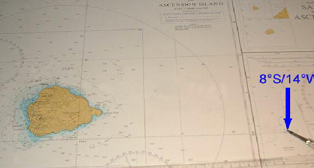
| 8°S 14°W |

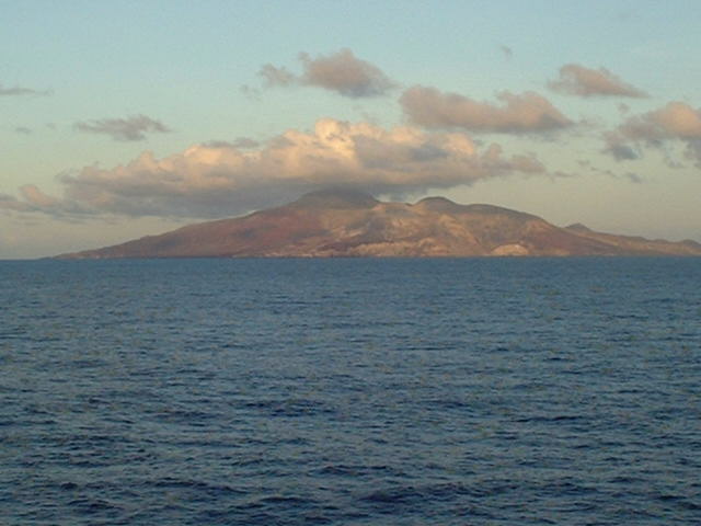
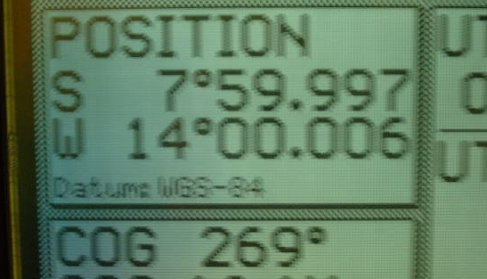
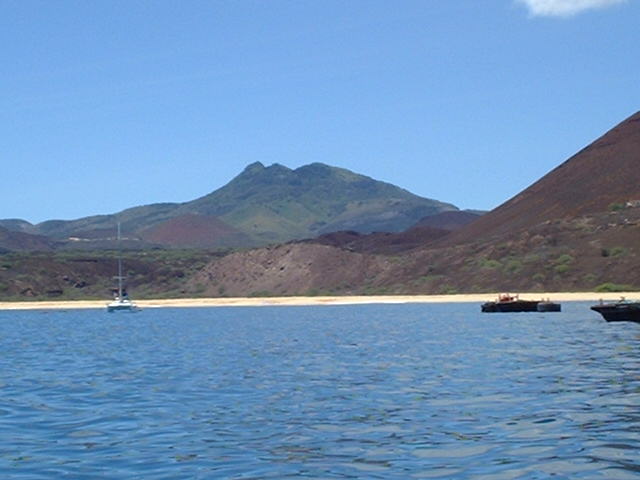
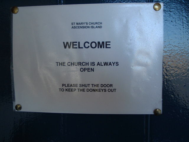
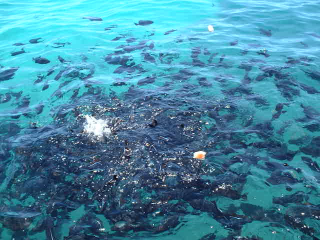
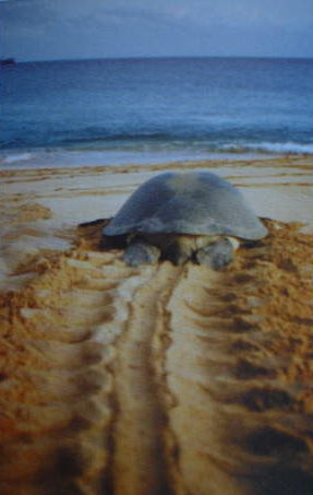
(visited by Captain Peter, Volodymyr Kokorev and Valentyn Smirnov) 21-Mar-2002 -- After having discharged a consignment of frozen mackerel at Douala (Cameroon), we were instructed to proceed to Argentina, in order to load apples and pears for St. Petersburg (Russia). On this course there is Ascension Island, the most isolated tropical island in the Atlantic. The Confluence is 33.3 km eastward, but due to the very fine weather the Island is perfectly visible from our GPS-position, which we failed to meet only a 12.5 metres too far in the NW at 09:25 am. About two years ago Captain Peter had the opportunity to visit this island and so we are able to attach a few pictures from this rather unknown part of the world. Ascension has an area of 34 sq. miles (88 km²) and a population of about 800 in 2002. It is an important telecommunication station and part of the British colony Saint Helena and Dependencies (the Colony consists of St. Helena, Ascension, Tristan da Cunha, Gough, Nightingale and Inaccessible Island). From the United States Air Force Auxiliary Airfield regular RAF-flights are maintained to and from the United Kingdom and the Falkland Islands. The RMS "Saint Helena", on her trade between England and Cape Town, calls the island regularly. The surface of Ascension Island is extremely irregular and when viewed from seaward presents a rugged and uninviting appearance. The greatest elevation, 857 m, is attained at The Peak, the summit of Green Mountain, which latter is so called from the color of its apex. There are about 40 cones of various magnitudes on the island, being extinct craters from many of which the courses of the lava streams may be traced on their way to the sea. Green Mountain is surrounded by numerous other craggy peaks of less elevation, having between them deep gorges and dark ravines. The island, however, is getting greener every year as introduced plants begin now to take hold. The islanders obtain water from the cement rain catchments on the mountains. It is conveyed through pipes to covered tanks in Georgetown, the capital of the island. Ascension Island was discovered in 1501 by João de Nova Gallego, a Portuguese, who named it Concepcão. Two years later it was visited by French (who did not know about the Portuguese expedition) and named Ascension. In 1775 Captain Cook was there and collected turtle meat. In the year 1815, the British Government took possession of the island and in 1821 it was garrisoned by a company of the royal Marines. In 1830 the collection of Government buildings and wooden houses was given the name of Georgetown, at which time the garrison consisted of 100 marines and 50 Kroo-men from the coast of Africa. By 1833, the island had been fortified at all accessible points, and the establishment numbered nearly 300 persons. In 1836 Charles Darwin visited the island and wrote there an account of geology. In 1877 a certain Professor Gill measured there the Sun's distance from the Earth. The first submarine telegraph cable had been laid in 1899, and in 1915 the first radio installation took place. In 1922 the garrison was withdrawn and the control of the island which up till then had been directly under the Admiralty, was transferred to the Colonial Office. The Americans constructed an airstrip in 1942, and in 1943 there were about 4,000 servicemen on the island. In 1966 NASA installations were built, and in 1982 the Falkland War led to great increase in military activity. The NASA station, however, has been closed in 1990, and an Ariane (European Space Agency Rocket) station was built. The climate is singularly healthy, and the salubrity of the island is attributed to its situation in the heart of the South-East Trade Wind and the complete absence of marshy soil. Horses, mules, cows, sheep, and donkeys have been imported at various times. The donkeys now run wild. Visitors of the church, for example, are advised to keep the church door always closed. Cats are numerous, but instead of destroying the rats, they prey on the sea-fowl that frequent the island to lay their eggs. Goats, rats, and land crabs, being enemies to cultivation, are destroyed whenever the opportunity offers, and may ultimately be exterminated, at least according to a feasibility study of 1995 to investigate how they could be finally removed. Insects are not troublesome. There are some Stegomyia (mosquitos) and a few scorpions and centipedes. A small blue mountain butterfly is sometimes seen. The indigenous birds include the Man-of-War bird, black and white, measuring sometimes as much as 2.1 m between the tips of its wings. There are two kinds of gannet, two of petrel and the boatswain bird. The sooty tern or wide-awake (Sterna fuliginosa) visits the island in great number during the laytime season, which is irregular and only occurs about three times in two years. Their eggs are considered by some to be a delicacy resembling to those of the plover, the egg is nearly as large as that of the common hen. There is an abundance of excellent fish to be caught throughout the year, such as rock-cod, conger-eel, cavalhoes etc. The best place for fishing is on the reefs near Georgetown. Crayfish are also caught, oysters are abundant and very tasty. But caution: Small fish, about 15 cm long, known locally as "Black Fish", swim around the anchored ships, and eating with their sharp teeths anything thrown into the water within seconds! They will attack humans as well, but according to my own experience only when they have an open cut or wound letting blood into the water. Blood drives these fish completely mad! Ascension Island is visited by the sea turtle (Chelonia mydas) between December and May. They migrate from Brazil to the tiny island, a distance of over 2,000 km. Here they mate offshore. How they navigate and find Ascension is not fully understood but it is possible that it is through a combination of smell and magnetic orientation. Each female then digs large pits (about 3 m in diameter and 80 cm deep), in which about 80 to 150 eggs are deposited and carefully covered over with sand. In nine or ten weeks the young turtles break out, and working their way through the sand, immediately take to the sea, after which they are never seen again until they are fully grown. Should this short journey, however, happen in daylight, many of the young animals are picked up and devoured by Man-of-War birds, who are ever hovering over the turtle-nests. Picture that it is estimated that less than one hatchling in a thousand will survive until adulthood, when it will return and complete the breeding circle! Historically these herbivorous sea turtles were an important source of fresh meat for passing ships. When turtles came ashore to lay their eggs they were easily captured. On such occasions men were stationed during the night in the bays they frequent, to turn them over on their backs, in which position they were of course perfectly helpless, and were thence transferred to ponds in the town formed for their reception. These turtle ponds can still be seen in Georgetown. The turtles were then kept alive onboard the ships until required. Nowadays, no turtles are taken for meat from Ascension and they are classified as endangered and protected under international law. The turning upside down of turtles is now strictly prohibited and any person guilty of a breach of this regulation is subject to a heavy penalty. The turtle when fully matured weighs 200 to 400 kg, and it is worthy to remark that no male turtles ever make their appearance on the beach. Sea turtles and their mating can be best watched from November to early March in the bays near Georgetown. Mating pairs are acting close to the shore and gelous males can be seen often fighting over females. But in order to reduce the level of disturbance everybody should adhere to a certain code of conduct:
(of course these guidelines are applicable to all turtles, not only on Ascension). Usually nobody is allowed on the island without the permission of the Administrator. There is a shop, and a small hospital, a bank, police station and a few restaurants and bars. An internet point can be visited at the Cable & Wireless building. Stamp collectors will enjoy the beautiful commemorative stamps and First Day Covers of Ascension. There are several wonderful beaches, which I highly recommend to visit - but always remember the Black fish! -------------------------------------------------------- |
| All pictures |
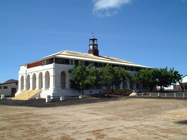
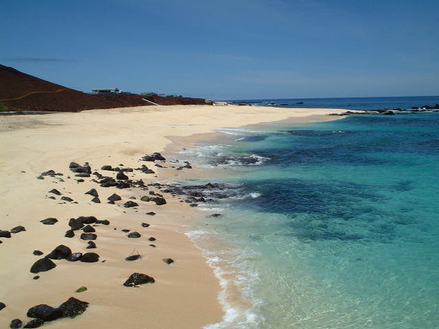
| #1: Ascension seen from the Confluence #2: Map #3: GPS reading #4: Capt. Peter off Ascension Island #5: The Peak, the summit of Green Mountain, right a part of Cross Hill near Georgetown #6: Ascension Island Government #7: No welcome for donkeys #8: Black Fish devouring pieces of bread #9: A sea turtle heading back towards the sea after laying #10: Beach near Georgetown ALL: All pictures on one page |
| Notes |
|
In the ocean, with a view of Ascension Island |