|

China : Tiānjīn Shì
3.4 km (2.1 miles) WSW of Zhangjiawo, Tiānjīn, China
Approx. altitude: 3 m
(9 ft)
([?] maps: Google MapQuest OpenStreetMap ConfluenceNavigator)
Antipode: 39°S 63°W
Quality: good
Click on any of the images for the full-sized picture.


| 39°N 117°E (visit #1) | (incomplete) |
![Visit #2: [31-Jan-04]](/cn/all/n39e117v2/preview.jpg "Visit #2: [31-Jan-04]")

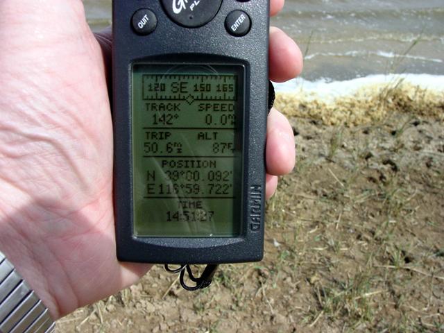
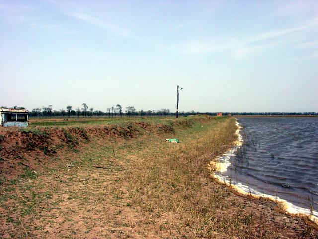
(visited by Keith Ketterer, Jeannette and Joi) 04-May-2002 -- We attempted to visit this confluence last fall but unfortunately the days were short and it got dark too early for a visit. No such problem on this day. Our earlier attempt made it easier for us to find the general area of the confluence which is about 90 minutes from our home. It turns out that the confluence is only a few hundred meters from the main Beijing-Shanghai super highway. All we had to do was drive to the exit just past 39N, make the first right and drive back to 39N on the road that roughly paralells the main highway about 1 1/2 Km to the west. When we recrossed 39N we made the first right onto a good quality dirt road. At this intersection there was a stone carving with the information that we were entering a "duck farm". (Photo #2) We drove down the duck farm road as far as we possibly could but still came up just short of 117E. We parked the car and proceeded to walk the remaining distance alongside fields that were being planted by local farmers. Additional proof that this was in fact a duck farm was provided when we had to navigate around numerous duck droppings. As we walked south toward 39N we noticed that a small ridge, maybe 3 meters high, had to be negotiated to continue toward our goal. We were unable see over the ridge so you can imagine our surprise when we climbed to the top to be greeted with the view of what can be called either a very large pond or a small lake depending upon your definition (Photo #1). Looking at the lake and then at my GPS I realized the the confluence was well out into the water! The wind was blowing hard enough to raise small whitecaps and a strange looking soap-like foam was washing up on to the shore. I took a photo of my GPS at the point where we first came across the lake (photo #3) and then moved on to the exact point where 39N enters the lake (39.00.000N 116.59.720E). Unfortunately the photo I took of my GPS at this point was unreadable but I also took photos at this point looking directly east across the lake to the confluence point (photo #4) and to the north and west (photos #5 and #6). Another Chinese confluence almost visited - maybe we'll have better luck next time. |
| All pictures |
| #1: The confluence is out there in the water. #2: Marker showing the entrance to the "Duck Farm" #3: GPS at the NW corner of the lake. #4: Looking directly east across the lake toward the confluence from 30.00.000N 116.59.720E #5: View toward the north. #6: Jeannette & Joi on the ridge overlooking the lake. ALL: All pictures on one page |