|

Germany : Hessen
1.5 km (1.0 miles) SSE of Mainhausen-Zellhausen, Hessen, Germany
Approx. altitude: 134 m
(439 ft)
([?] maps: Google MapQuest OpenStreetMap ConfluenceNavigator)
Antipode: 50°S 171°W
Accuracy: 10 m (32 ft)
Quality: good
Click on any of the images for the full-sized picture.


")


| 50°N 9°E (visit #5) |
![Visit #25: [13-Dec-23]](/de/all/n50e009v25/preview.jpg "Visit #25: [13-Dec-23]")
![Visit #24: [16-Jun-23]](/de/all/n50e009v24/preview.jpg "Visit #24: [16-Jun-23]")
![Visit #22: [21-Jul-22]](/de/all/n50e009v22/preview.jpg "Visit #22: [21-Jul-22]")
![Visit #21: [10-May-18]](/de/all/n50e009v21/preview.jpg "Visit #21: [10-May-18]")
![Visit #20: [16-Aug-15]](/de/all/n50e009v20/preview.jpg "Visit #20: [16-Aug-15]")
![Visit #19: [20-Nov-14]](/de/all/n50e009v19/preview.jpg "Visit #19: [20-Nov-14]")
![Visit #18: [05-Apr-14]](/de/all/n50e009v18/preview.jpg "Visit #18: [05-Apr-14]")
![Visit #17: [01-Mar-14]](/de/all/n50e009v17/preview.jpg "Visit #17: [01-Mar-14]")
![Visit #16: [10-Jul-13]](/de/all/n50e009v16/preview.jpg "Visit #16: [10-Jul-13]")
![Visit #15: [02-Mar-09]](/de/all/n50e009v15/preview.jpg "Visit #15: [02-Mar-09]")
![Visit #14: [25-Feb-09]](/de/all/n50e009v14/preview.jpg "Visit #14: [25-Feb-09]")
![Visit #13: [26-Dec-08]](/de/all/n50e009v13/preview.jpg "Visit #13: [26-Dec-08]")
![Visit #12: [01-Aug-08]](/de/all/n50e009v12/preview.jpg "Visit #12: [01-Aug-08]")
![Visit #11: [29-Nov-07]](/de/all/n50e009v11/preview.jpg "Visit #11: [29-Nov-07]")
![Visit #10: [05-May-05]](/de/all/n50e009v10/preview.jpg "Visit #10: [05-May-05]")
![Visit #9: [23-Jan-05]](/de/all/n50e009v9/preview.jpg "Visit #9: [23-Jan-05]")
![Visit #6: [22-Feb-03]](/de/all/n50e009v6/preview.jpg "Visit #6: [22-Feb-03]")
![Visit #4: [23-Dec-01]](/de/all/n50e009v4/preview.jpg "Visit #4: [23-Dec-01]")
![Visit #3: [06-Oct-01]](/de/all/n50e009v3/preview.jpg "Visit #3: [06-Oct-01]")
![Visit #2: [02-Sep-01]](/de/all/n50e009v2/preview.jpg "Visit #2: [02-Sep-01]")
![Visit #1: [10-Dec-00]](/de/all/n50e009/preview.jpg "Visit #1: [10-Dec-00]")
![Visit #23: [10-May-14]](/de/all/n50e009v23/preview.jpg "Visit #23: [10-May-14]")
![Visit #7: [25-Jul-04]](/de/all/n50e009v7/preview.jpg "Visit #7: [25-Jul-04]")
![Visit #8: [31-Jul-04]](/de/all/n50e009v8/preview.jpg "Visit #8: [31-Jul-04]")
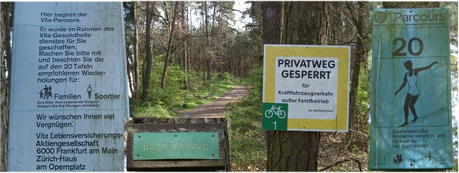
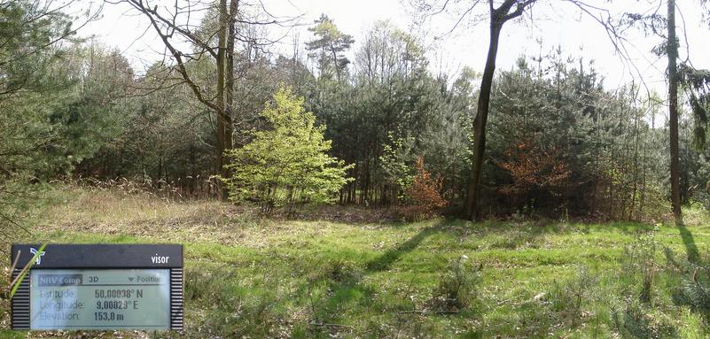
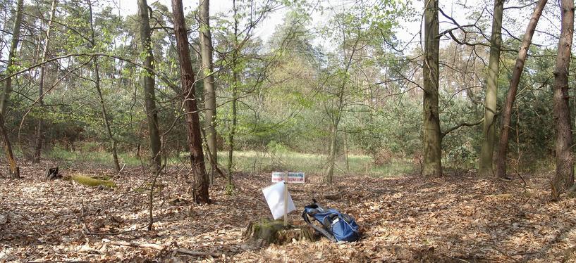
 (visited by Hans Augdoppler) 21-Apr-2002 -- My routing software, MapPoint Europe, suggested to leave the motorway A3 over the ‚Seligenstädter Kreuz’ and then via the A45 towards ‚Zellhausen bei Seligenstadt’. The ,Buchenlohweg’ after the crossing of a local railway line in direction SOUTH ended at a parking lot with a barrier [50,004°N;8,996°E]. The forest consists of beeches and pines. The path is designated as fitness path but primarily used by stroller and cyclists. Within the CP range there are several forest tracks. The direct entrance takes you through a row of young trees. Now you are able to hear the noise of the motorway A3 as already known from the other visitors. The CP is located in a clearing a few meter off the motorway embankment. However I could not discover any markings from the previous visitors.
On the way back to the A3 towards Frankfurt/Main I discovered two more points of access to the CP: Map in pic#7 © MapPoint Europe http://www.microsoft.com 21-Apr-2002 -- Mein Wegweiser, MapPoint, schlug vor, die Autobahn A3 über das ‚Seligenstädter Kreuz’ und die A45 in Richtung ‚Zellhausen bei Seligenstadt’ zu verlassen. Der ‚Buchenlohweg’ in Richtung SÜDEN endete nach der Überquerung einer lokalen Bahnlinie an einer Schranke mit Parkplatz [50,004°N;8,996°E]. Der Weg führte durch einen Wald aus Buchen und Kiefern. Er ist als Trimmpfad ausgeschildert und wird in erster Linie als Wander- und Fahrradweg benützt. Im Bereich des CP gibt es mehrere Waldwege. Der direkte Zugang führte durch ein Gebüsch von jungen Bäumen. Der Lärm der Autobahn A3 kam immer näher und wie bereits von den Vorbesuchern bekannt, ortete ich den CP in einer Lichtung ein paar Meter von der Autobahnböschung. Ich konnte jedoch keinerlei Markierung entdecken.
Auf dem Weg zurück zur A3 in Richtung Frankfurt/Main konnte ich zwei weitere Zugangspunkte zum CP entdecken: For more information see: http://linz.orf.at/gast/augdoppl/Confluence/Main.htm |
| All pictures |
| #1: Confluence - view to NE #2: Parking – outskirt of Zellhausen #3: ‚Buchenlohweg’ as fitness path #4: Romantic forest trails #5: Approach towards Autobahn (SSW) #6: Railway crossing at boundary of Zellhausen #7: A3 parking bay ‘Mainhausen’ – another access point #8: The spot, the A3, map & GPS reading ALL: All pictures on one page |