|

Austria
2.2 km (1.4 miles) SE of Gattendorf, Burgenland, Austria
Approx. altitude: 134 m
(439 ft)
([?] maps: Google MapQuest OpenStreetMap ConfluenceNavigator)
Antipode: 48°S 163°W
Accuracy: 50 m (164 ft)
Quality: good
Click on any of the images for the full-sized picture.


| 48°N 17°E (visit #3) |
![Visit #21: [30-Dec-18]](/at/all/n48e017v21/preview.jpg "Visit #21: [30-Dec-18]")
![Visit #20: [15-Aug-17]](/at/all/n48e017v20/preview.jpg "Visit #20: [15-Aug-17]")
![Visit #18: [11-Feb-16]](/at/all/n48e017v18/preview.jpg "Visit #18: [11-Feb-16]")
![Visit #17: [12-Aug-15]](/at/all/n48e017v17/preview.jpg "Visit #17: [12-Aug-15]")
![Visit #16: [26-Jul-15]](/at/all/n48e017v16/preview.jpg "Visit #16: [26-Jul-15]")
![Visit #15: [07-Jun-15]](/at/all/n48e017v15/preview.jpg "Visit #15: [07-Jun-15]")
![Visit #14: [25-Oct-14]](/at/all/n48e017v14/preview.jpg "Visit #14: [25-Oct-14]")
![Visit #13: [12-Sep-14]](/at/all/n48e017v13/preview.jpg "Visit #13: [12-Sep-14]")
![Visit #12: [10-May-10]](/at/all/n48e017v12/preview.jpg "Visit #12: [10-May-10]")
![Visit #11: [09-Jun-08]](/at/all/n48e017v11/preview.jpg "Visit #11: [09-Jun-08]")
![Visit #10: [29-Apr-07]](/at/all/n48e017v10/preview.jpg "Visit #10: [29-Apr-07]")
![Visit #9: [03-Jul-06]](/at/all/n48e017v9/preview.jpg "Visit #9: [03-Jul-06]")
![Visit #8: [29-Jan-05]](/at/all/n48e017v8/preview.jpg "Visit #8: [29-Jan-05]")
![Visit #7: [29-Aug-04]](/at/all/n48e017v7/preview.jpg "Visit #7: [29-Aug-04]")
![Visit #6: [28-Aug-04]](/at/all/n48e017v6/preview.jpg "Visit #6: [28-Aug-04]")
![Visit #5: [17-Aug-04]](/at/all/n48e017v5/preview.jpg "Visit #5: [17-Aug-04]")
![Visit #4: [05-Feb-04]](/at/all/n48e017v4/preview.jpg "Visit #4: [05-Feb-04]")
![Visit #2: [07-Jan-01]](/at/all/n48e017v2/preview.jpg "Visit #2: [07-Jan-01]")
![Visit #1: [06-Jan-01]](/at/all/n48e017/preview.jpg "Visit #1: [06-Jan-01]")
")
(visited by Hans Augdoppler and Klaus Baumgartner) 22-Jun-2002 -- While travelling along the federal road B10 (Budapester Bundesstraße) we saw that harvesting was already under progress. It was thrilling whether field concerning now is already harvested. The distance is about 200 from the road, in the direction of NORTH EAST. We passed the village of Zurndorf and then we found out area around the CP was not yet harvested. This agricultural area is characterized by the small farmers; therefore the fields are long and very narrow. We went along the limit of a sugar beet field and a barley field in the direction of the CP. Between us and the exact point lies the barley field, a wheat field and at the end a corn field. Due to the advanced maturity condition of the grain we avoided entering these fields. Either the exact point already lies in the wheat field or else in the corn field. The information from the pre-visitors said something about corn but this year according to the practice of fruit change this could be the wheat field, too. The river Leitha flows past in the background of the CP. In the direction of the SSW one can recognize a wind power plant. We finally left the area in the direction of the Gattendorf village. For more information see: http://linz.orf.at/gast/augdoppl/Confluence/Main.htm |
| All pictures |
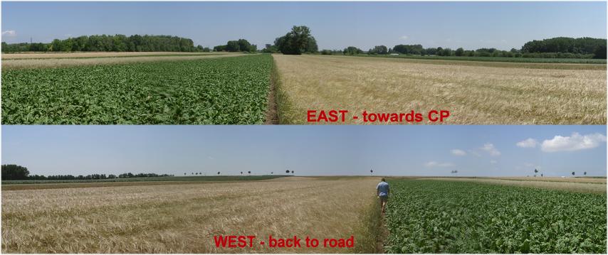
| #1: Above a thistle looking at the confluence area (EAST) #2: Entering Zurndorf from SOUTH with church #3: Approach from B10 with CP indicator #4: Panorama from WEST to CP & from CP to WEST #5: CP access & localization process #6: Wind power plant in direction SOUTH #7: GPS readings ALL: All pictures on one page |