|

Faroe Islands
1.5 km (0.9 miles) NW of Koltur (Island), Faroe Islands
Approx. altitude: 0 m
(0 ft)
([?] maps: Google MapQuest OpenStreetMap ConfluenceNavigator)
Antipode: 62°S 173°E
Accuracy: 6.5 km (4.0 mi)
Quality: good
Click on any of the images for the full-sized picture.

| 62°N 7°W (visit #1) | (incomplete) |
![Visit #3: [02-Jul-25]](/fo/all/n62w007v3/preview.jpg "Visit #3: [02-Jul-25]")
![Visit #2: [19-Jul-02]](/fo/all/n62w007v2/preview.jpg "Visit #2: [19-Jul-02]")

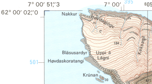
(visited by Poul-Henning Kamp) 09-Jul-2002 -- I went to the Faroe islands on honeymoon and noticed that this confluence hadn't been attempted yet, but seeing the "3.2km NW of Koltur" made me give up any hope of actually managing to visit it. The current and wind between the Faroe islands is known for being really really evil, so the prospect of sailing out into the middle of some of the worst of it was not even considered. After arriving I glanced at a map and realized that the confluence is much closer to or in fact maybe on the coast of Koltur. The closest I got was about 6.5km on a trip to "Trøllkonufingur" and the picture is taken from there. Picture #2 below is actually a scan from the 1:20000 map of the relevant area. The map is in ED50 datum so the coordinates are a tiny bit off. Koltur was only about two square kilometers, but as you can see in the bottom right corner of the map it manages to rise to 477m height. As you can see it doesn't exactly look like a good place for a family picnic. I cannot tell for sure if overland or over sea would be the right approach, it may in fact be that it will be impossible to reach the confluence from either element. It should be possible to get to the relevant area of the coast overland, but you may have to be an experiences climber to manage that. I saw no sheep at all on that area of the island, which I think is a a bad omen for a land-side approach. You can get to the island by boat or by helicopter, and from what I gather, the helicopter is both cheaper, safer and much more pleasant. A seaside approach may be the kind of venture that will teach you everything you ever wanted to know about sea-sickness, but if you can't get a local skipper to sail you there, you should certainly not try to do it on you own. Apparently the island was for many years inhabited by two families who were not even talking to each other. I have not been able to find out why or for how long, but there is probably a good story there. Today a single couple lives there and that is probably the key to successfully visiting this confluence. I see two ways this confluence could be visited. Either somebody from the Faroe Islands does it, in which case I am in no position to give useful advice. Alternatively somebody does it on a trip up there in which case my advice is to contact Bjørn Patúrsson as the very first thing before you even book your tickets. As a vacation, the Faroe islands gets my warmest recommendations. Poul-Henning |
| All pictures |
| #1: Koltur seen from North #2: 1:20000 map showing the confluence ALL: All pictures on one page |
| Notes |
|
Just about 50 m off the coast of the small island Koltur. |