|

Canada : British Columbia
29.5 km (18.3 miles) SE of Salmo, BC, Canada
Approx. altitude: 1966 m
(6450 ft)
([?] maps: Google MapQuest OpenStreetMap topo topo250 ConfluenceNavigator)
Antipode: 49°S 63°E
Accuracy: 2.8 km (1.7 mi)
Quality: good
Click on any of the images for the full-sized picture.


| 49°N 117°W (visit #2) | (incomplete) |
![Visit #4: [16-Jul-04]](/ca/bc/n49w117v4/preview.jpg "Visit #4: [16-Jul-04]")
![Visit #3: [02-May-04]](/ca/bc/n49w117v3/preview.jpg "Visit #3: [02-May-04]")
![Visit #1: [30-Jun-02]](/ca/bc/n49w117/preview.jpg "Visit #1: [30-Jun-02]")

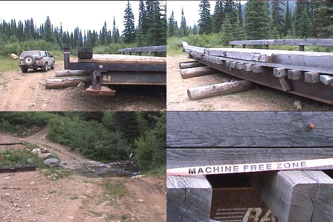
(visited by Dave Patton) 01-Aug-2002 -- After leaving 49°N 118°W I drove east through Rossland, Trail, Fruitvale, and Salmo, then continued east on Highway 3 towards Creston. The first approach attempted in the first visit to this confluence, although not named in their narrative, is, I believe, the Monk Creek FSR(Forest Service Road). I was watching for a sign along the highway as I neared Kootenay Summit, but I missed it. I found out later from this Forest Service information that the road starts at the back of a Highways maintenance yard. Like the first visitors, I ended up going further east along the highway, and turning off onto the Maryland Creek FSR. I came to a junction, where I went right on Monk Creek FSR - Boundary Lake FSR was to the right. After crossing under some power lines and crossing a bridge, I turned left to head towards the Priest River Falls recreation site. This turned out to be nothing more than a spot to view the falls. As I headed further up this road, I came across a deer. Shortly after this I came to a spot where a bridge had been removed from a stream crossing. There wasn't much water in the stream, so I drove through and kept going up the road, hoping to at least get close to the confluence. I tried a couple of branches on this road, but didn't get any further than a couple of kilometers. Aside from being muddy and rough, it appears that some spots in this area, including the old roads, have recently had trees planted, often on the tops of mounds of earth created by heavy equipment. This is called "mounding", and is done in tree-planting so that the young trees are planted higher than the surrounding ground in areas that are too wet for the trees. My guess is that after this planting, the equipment was driven out of the area, and then the bridge was removed. By this time it was almost 5PM, so I had to make a decision. I wasn't going to get to the confluence today, so I either needed to find a camp spot and try it tomorrow, or else continue on to the southeastern corner of BC. The area I was in wasn't suitable to camp at, both because of all the flies and mosquitoes, and because I was on the "wrong" side of a stream with no bridge, and the forecast of thundershowers. I decided to call this an attempt, and drive further east towards 49° 116°W. Back at the stream I took a picture of my truck in the stream. A short while after driving away from this spot I felt a sharp, momentary, pain on the back of my right heel. I was wearing sandals, and my feet were wet from having walked in the stream, and I thought I had just been bitten by one of the many flies. I slowed down, but couldn't see the offending fly. A little while later the same thing happened, so this time I stopped and got out, determined to get rid of the pesky fly. That's when I noticed the steam rising from the floormat under my feet! It turns out it wasn't a fly biting me, but rather it was little "blasts of steam" that would come up between a crack in the floormat when I moved my foot. I had for quite a while an exhaust leak in my truck, under the driver's side floorboard, but I didn't realize until that moment the real problem. I just thought it was a leak that was a bit annoying, and that I'd get it fixed 'one of these days'. It turns out the leaking hot exhaust gasses had been heating up the floorboard, and burning the underside of the carpet. The result once the water from my feet and sandals got through the crack in the floormat was the steam. I was already over 800 kilometers into this trip, had not yet reached the area of the confluences I really wanted to tackle, and knew I was going to have more driving around on logging roads with few people around. I decided this trip was to be cut short, and headed back to Vancouver, camping overnight, and arriving home the next day. |
| All pictures |
| #1: view at the closest approach #2: Priest River falls #3: a nice deer #4: the 'missing' bridge #5: on the way out #6: Ripple Ridge Cabins info ALL: All pictures on one page |
| Notes |
|
The borderline with the U.S. is running about 90 m south of the Confluence. |