|
Japan : Chūbu
1.9 km (1.2 miles) N of Tatsuno, Tatsuno-machi, Nagano-ken, Chūbu, Japan
Approx. altitude: 957 m
(3139 ft)
([?] maps: Google MapQuest OpenStreetMap ConfluenceNavigator)
Antipode: 36°S 42°W
Accuracy: 10 m (32 ft)
Quality: good
Click on any of the images for the full-sized picture.
| 36°N 138°E (visit #1) |

(visited by Holger Baumgardt) 07-Mar-2004 -- After hearing about the confluence project, I decided to visit a few of the remaining unvisited confluences in Japan. The one within easiest reach from Tokyo seemed to be 36N 138E, so I decided to start with this one. Also when searching the internet for information, I noticed that the geographical center of Japan is less than 2km from the confluence, making the visit even more interesting. Leaving Tokyo at 6am, I took the Chuo-sen railway to Okaya, then changed to an Iida-sen train which brought me directly to Tatsuno. The confluence is 2km from the station on a steep mountain north of Tatsuno. There is a surfaced road which winds its way up the mountain, making it easy for a car to get near confluence. Since it was early March when I went, I of course had to walk because everything was deeply covered with snow. But it was a sunny day and the forest looked really great. After walking for about two kms, I came to a fork in the road. I decided to first head for the center of Japan since the way to the center is signposted and I knew there would be a monument which marks the exact location. So I turned left and reached the monument at about 11am. The confluence looked quite a bit harder. According to the GPS, it had to be somewhere on the eastern side of the mountain, but I could not find a road leading anywhere near it. Also the mountain seemed to be rather steep on all sides and densely covered with trees and underwood, making walking for just 100 meters in any direction already look very tough. What was to be done? I first walked back to the fork in the road which was about 900 meters from the confluence. Taking this time the turn to the right brought me to the top of the mountain, where the road ended. According to the GPS the confluence had to be 800 meters north from there. I walked around a deserted house and found much to my joy a trail heading further north. The trail seems to be used for some pilgrimage or something since there was a typical Japanese stone gate at its entrance. It led me to within 400 meters, but then suddenly turned to the left, while I had to go to the right. Luckily at this point the mountain was not very steep making it easy to follow the GPS downhill. Near the confluence the recption became a bit unstable but I finally reached a point within the accuracy of my GPS from the confluence, so I could bag in my second objective of the day. The way back was no problem and I was back at my house in Tokyo 12 hours after I left. Overall this was a very nice confluence and a great day to get away from busy Tokyo. |
| All pictures |
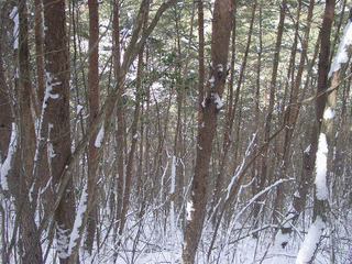
| #1: View of the confluence point, really lots of trees #2: View from the confluence to the southeast, more trees #3: The split in the road, the center of Japan is to the left, the confluence to the right #4: Monument marking the center of Japan #5: Stone gate at the entrance of the path to the confluence #6: GPS reading #7: View from the mountain down to Tatsuno ALL: All pictures on one page |


![Visit #2: [16-Nov-06] Visit #2: [16-Nov-06]](/jp/all/n36e138v2/preview.jpg)