|

Germany : Mecklenburg-Vorpommern
3.3 km (2.0 miles) WSW of Ückeritz, Usedom (Peninsula), Mecklenburg-Vorpommern, Germany
Approx. altitude: 0 m
(0 ft)
([?] maps: Google MapQuest OpenStreetMap ConfluenceNavigator)
Antipode: 54°S 166°W
Quality: good
Click on any of the images for the full-sized picture.


| 54°N 14°E (visit #1) | (secondary) |
![Visit #9: [16-Jul-17]](/de/all/n54e014v9/preview.jpg "Visit #9: [16-Jul-17]")
![Visit #7: [24-May-12]](/de/all/n54e014v7/preview.jpg "Visit #7: [24-May-12]")
![Visit #6: [13-Aug-11]](/de/all/n54e014v6/preview.jpg "Visit #6: [13-Aug-11]")
![Visit #5: [31-Dec-10]](/de/all/n54e014v5/preview.jpg "Visit #5: [31-Dec-10]")
![Visit #4: [28-Aug-08]](/de/all/n54e014v4/preview.jpg "Visit #4: [28-Aug-08]")
![Visit #3: [23-Aug-02]](/de/all/n54e014v3/preview.jpg "Visit #3: [23-Aug-02]")
![Visit #2: [22-Jul-01]](/de/all/n54e014v2/preview.jpg "Visit #2: [22-Jul-01]")
![Visit #8: [24-Jan-16]](/de/all/n54e014v8/preview.jpg "Visit #8: [24-Jan-16]")
![Visit #10: [16-Oct-10]](/de/all/n54e014v10/preview.jpg "Visit #10: [16-Oct-10]")

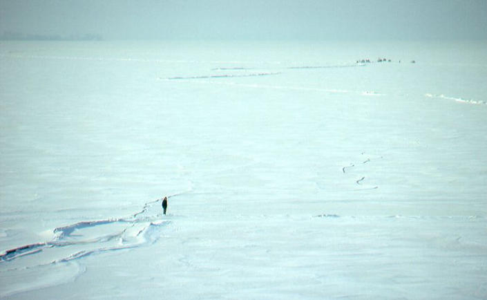
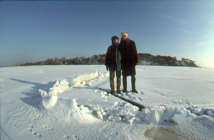
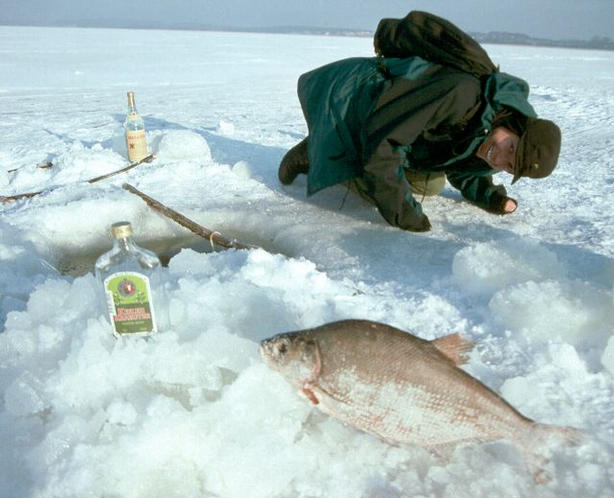
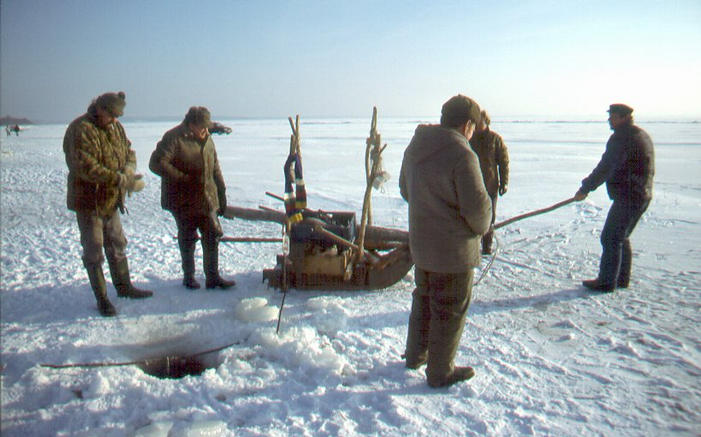
(visited by Andreas Tietze and Andreas Faulstich) 31-Dec-1995 -- Mit dem Auto auf dem Meer zum Confluence Point 54N 14E Zum Jahresende 1995 liehen wir uns ein Mietauto, um von Berlin aus die Insel Usedom vor der Ostseeküste zu besuchen und anschließend mit Freunden auf der Insel Hiddensee Silvester zu feiern. An einem sonnigen und eiskalten Tag erreichten wir die Binnenküste der Insel Usedom in der Nähe des Dorfes Loddin. Herrlich verschneit lag die Landschaft da. Von der Steilküste hatten wir einen weiten Blick über das Achterwasser, so heißt das Meer zwischen Usedom und Festland. Es war zugefroren und mit dickem Eis bedeckt. Auf dem Eis sahen wir in etwa einem Kilometer eine Menschenansammlung. Wir fragten uns, was die Leute dort wohl machten. Bei dem Blick in unsere Karte sahen wir, dass sich dort die Koordinatenlinien des 14. Längengrades Ost und des 54. Breitengrades Nord schneiden mussten. Das fanden wir merkwürdig. Was ging da vor sich? Zunächst gingen wir zu Fuß auf das Eis, doch als wir einige Autos auf das Eis fahren sahen, kehrten wir schnell zu unserem Auto zurück und fuhren hinterher. Gut, dass der Autovermieter nicht ahnte, was wir mit seinem neuen Auto anstellten. Als wir die Leute auf dem Eis erreichten, sahen wir, dass dort einige Löcher ins Eis gehackt waren. Versuchten da etwa Geologen, den Confluence Point mit einem Loch zu markieren? Und welches Loch war wohl das richtige? Doch schon sahen wir, wie einige Männer eine Leine aus einem Eisloch zogen und einen zappelnden Fisch auf das Eis warfen. Wir lernten, dass die Fischer des Ortes in besonders harten Wintern statt mit Booten mit dem Auto auf das Meer fahren, um Fische zu fangen. Eine Weile beobachteten wir die Fischer, bis es uns zu kalt wurde. Da stiegen wir wieder in unser Auto und drehten noch einige Runden auf dem weiten Eisfeld. Besonders lustig fanden wir es, in schneller Fahrt plötzlich zu bremsen oder in eine zu enge Kurve zu fahren. Wir mußten nur genug Abstand von den Eislöchern halten und von einer Verwerfung, wo zwei mächtige Eisfelder sich gegenseitig in die Höhe gedrückt hatten. Als wir jedoch an einer Stelle ein lautes Knacken und Knallen im Eis hörten, beeilten wir uns, schnellstmöglich wieder das Festland zu erreichen. Wie hätten wir dem Verleiher den Verlust des Autos erklären sollen? Damals wussten wir noch nichts von dem Confluence Point Projekt. Gab es das damals überhaupt schon? Wir hatten auch noch kein GPS und konnten deshalb auch den Schnittpunkt, den wir in der Karte gesehen hatten nicht den Punkt genauer lokalisieren. Der Punkt muss aber auf einem unserer Fotos sein und bei unsererm Eis-Spaziergang und der wilden Autofahrt haben wir ihn sicher berührt. Seitdem wir uns selbst mit Fotos und Berichten am Confluence Projekt beteiligen, wollten wir auch die Dokumentation zu diesen prähistorischen Confluence Point noch einreichen. Aber wir warteten zunächst auf die Fotos und die GPS-Bestätigung durch unsere Nachfolger. Im Vergleich der Fotos können wir nun erkennen, dass wir damals tatsächlich dort waren. Andreas Tietze (Text und Fotos) und Andreas Faulstich (Text) 31-Dec-1995 -- Sea journey by car to Confluence POINT 54N 14E At the end of the year 1995 we rented a car, to travel from Berlin to the island Usedom off the German shore of the Baltic Sea. On the second day (Dec. 31st 1995) we drove to the village Loddin at the mainland side of the island. It was sunny but very cold. The beautiful landscape was covered in glittering snow. From the steep coast we had a view far over the Achterwasser, as the sea between Usedom and mainland is called. It was frozen and covered by thick ice. On the ice about a kilometer away we saw a gathering of people. We wondered what they were doing there. We looked at our map and realized the confluence of the coordinate lines 54N and 14E was roughly there. What strange happening took place there? First we trod on the ice by foot, but when we saw some autos driving over the ice, we quickly returned to our own auto and followed them. We were happy that the car rental service did not suspect how we used its new car. When we arrived by the people we saw that they had chopped some holes through to the water. Were they geologists who tried to mark the confluence point with a hole? And which hole was the correct one? But suddenly the secret was disclosed: A man pulled a line from one hole to the next and threw a dithering fish upon the ice. We learned that the local fishermen had changed from boats to cars to travel over the sea and catch some fish. We watched them a while until it became too cold for us. We took our car to drive over the vast icefield and found it particularly merry to drive fast and brake hard or to go into narrow turns. We were careful not to come to close to the holes or to the distortion, where two powerful ice fields had pressed up. But suddenly we heard a loud cracking noise and hurried to return to the shore. How should we have explained the loss of the car to the rental service? At that time we didn't know anything about the Confluence project. Did it exist then either? We had no GPS and no other means to locate the confluence point except our map. However the point must be on one of our photos and we are sure that we touched it with our ice walk and the wild car drive. When we discovered the Confluence project this year we at once realized that we had visited this conflucenc point years ago. It was sort of a prehistoric confluence point visit. We decided to submit the point but to wait until we saw the photos and GPS validation of our successors. Now in the comparison of the photos we are certain that we were actually there. Andreas Tietze (text and photos) and Andreas Faulstich (text) |
| All pictures |
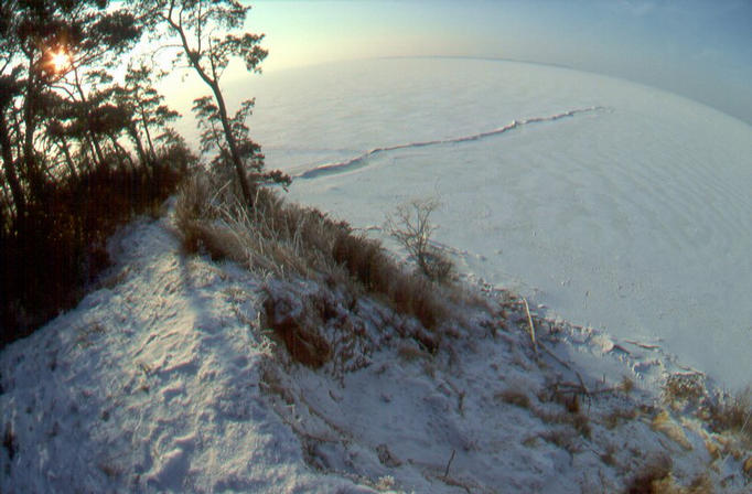
| #1: View S from the steep coast in the direction of the CP on the icebreak-line. #2: A white sunny day, on the way to the coast near Loddin #3: Andreas F - icebreak-line - fishermen camp #4: Our CP: breaks out icelines sparkling, view E #5: A&A near CP on the icebreak, view N to steep coast #6: Arriving with a not too heavy rental car on ice-camp, view N #7: Is this the right hole Mr. Geologist? Andreas F and frozen-fish #8: Frozen-fish, Andreas T, our car, view NE #9: Some ice-fishers at another hole, view NE ALL: All pictures on one page |
| Notes |
|
In the waters of the Achterwasser, 1.2 km from the shore. |