|

Iceland
5.8 km (3.6 miles) SSE of Keta, Skagafjarðarsýsla, Iceland
Approx. altitude: 124 m
(406 ft)
([?] maps: Google MapQuest OpenStreetMap ConfluenceNavigator)
Antipode: 66°S 160°E
Accuracy: 25 m (82 ft)
Quality: good
Click on any of the images for the full-sized picture.


")


| 66°N 20°W (visit #1) |
![Visit #6: [03-Sep-23]](/is/all/n66w020v6/preview.jpg "Visit #6: [03-Sep-23]")
![Visit #5: [03-Jun-23]](/is/all/n66w020v5/preview.jpg "Visit #5: [03-Jun-23]")
![Visit #4: [11-Jul-20]](/is/all/n66w020v4/preview.jpg "Visit #4: [11-Jul-20]")
![Visit #3: [10-Jul-19]](/is/all/n66w020v3/preview.jpg "Visit #3: [10-Jul-19]")
![Visit #2: [21-Oct-01]](/is/all/n66w020v2/preview.jpg "Visit #2: [21-Oct-01]")
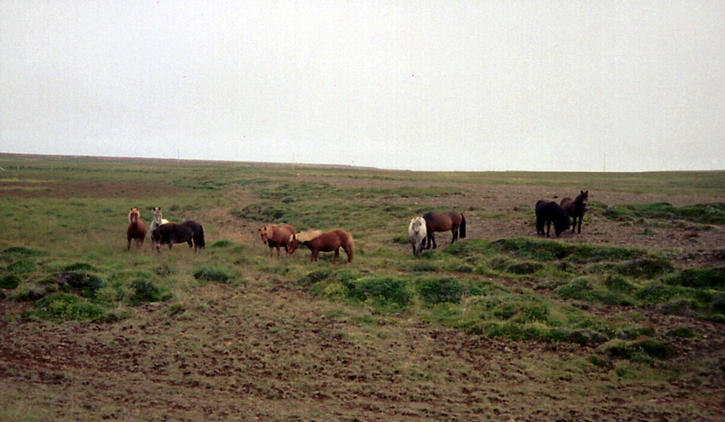
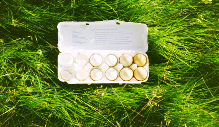
 (visited by Eva Buehlmann and Reto Stöckli) 21-Aug-2001 -- On our one month lasting bike-trip in Iceland we had the possibility to visit this confluence. After tasting tea & cakes in Reykjavik for three rainy days we loaded our bikes on the bus on 21st August, 2001 and stopped in Varmahlid on the Northern Coast. As many locals had told us, the weather was really much nicer in the north and despite the higher latitude it was some degrees warmer than in Reykjavik. On Wednesday, 22nd August we biked to Skagafjördur and set up our tent on a farm uphill of the fishing village Saudarkrokur - having a good sea view from there. In the evening sun was shining, socks were drying and we filled our stomaches by collecting sweet blue berries on the slopes of the Tindastöll Mountain. Mixing them with the Icelandic speciality called Skyr was a delicious substitute for our Birchermüesli. We set the alarm clock at seven for the next morning and started riding our bikes on the route 745 northwards (Picture 4), which is one of the tough Icelandic gravel tracks and usually frequented by 4x4 off road vehicles. Well, to be honest, we saw no other bikers during this confluence trip. Taking our time on our "1x1 driven steel horses" we passed through wilderness, along abondoned farms and saw paranoid sheep. Yes, the sheep were so afraid of harmless bikers and took off in a rush immediately after we were getting close to any of them. On our trip we followed the Laxa river to the East Coast of the Penninsula Skagaheidi. We passed the Hvalnes farm and after a steep slope we left our bikes and hiked around one km westwards to the confluence. The hike was not that challenging exept for the lava rocks lying all over the place. Getting closer to the actual confluence point we saw this very nice lake which didn't appear anywhere on our map. We need to mention here that our only map was in the 1:500'000 scale and one can have quite some surprises when doing confluence hunting with such a coarse-scale piece of paper. Eva was staring at the GPS (Picture 5) and got more and more nervous when she circled the lake almost entirely and noticed that the point was positioned exactly in the middle of the freezing deep blue water. Since the weather was worsening with winds and rain coming up and our fingers were already cold, we looked for the closest spot to the confluence along the lake border (Picture 3) - 25.7 m distance (Picture 2). To get closer one would need a boat or probably a neoprene suit when swimming. The panoramic photograph (Picture 1) we took from the site shows the hilly surroundings as well as the nice lake. Some sheep and wild Icelandic horses were grazing in the area (Picture 6). We headed back to our bikes quickly - perhaps too quickly since we lost the trails quite a bit too often and had a hard time to find the bikes again. Being so focused on the confluence itself there was no time to mark the position of our bikes before we started hiking. We then had a quick lunch swallowing farmersticks and dried stinky bananas. After the three hour ride back to our tent we were so happy to enjoy our self made meal consisting of smashed potatoes with 12 fried eggs (kindly provided by the farmer's wife) and topped with Swiss Gruyère cheese (Picture 7). That day was quite an experience and our Iceland trip was waiting for a next confluence... |
| All pictures |
| #1: A panoramic view from the confluence point #2: The GPS at the closest point to the confluence at the shore #3: Yeah we did it! #4: Biking in the misty morning #5: Where is it? (image stitched) #6: friendly Icelandic horses #7: Our dinner-plate ALL: All pictures on one page |
| Notes |
|
In a small lake. |