|

Oman
2.4 km (1.5 miles) E of Hijāriy, al-Bātina, Oman
Approx. altitude: 25 m
(82 ft)
([?] maps: Google MapQuest OpenStreetMap ConfluenceNavigator)
Antipode: 24°S 123°W
Accuracy: 10 m (32 ft)
Quality: good
Click on any of the images for the full-sized picture.


| 24°N 57°E (visit #1) |
![Visit #5: [13-Jan-13]](/om/all/n24e057v5/preview.jpg "Visit #5: [13-Jan-13]")
![Visit #4: [02-Apr-10]](/om/all/n24e057v4/preview.jpg "Visit #4: [02-Apr-10]")
![Visit #3: [29-Dec-06]](/om/all/n24e057v3/preview.jpg "Visit #3: [29-Dec-06]")
![Visit #2: [24-Jan-06]](/om/all/n24e057v2/preview.jpg "Visit #2: [24-Jan-06]")

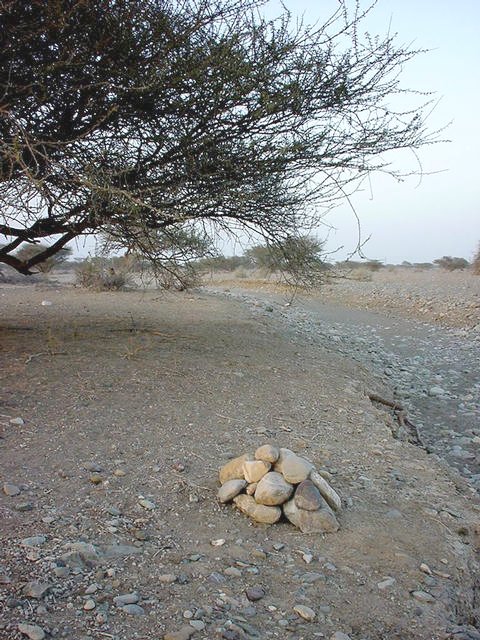
(visited by Stefan Beck, Martina Beck, Josefa Mayr and Alexander Beck) 05-Feb-2002 -- On our way to Masqaṭ, Oman on 5 February 2002 we decided to visit Confluence 24E 57N. This Confluence is in northern Oman on the al-Bāṭina coast near the village of al-Minzafa. The al-Bāṭina coast runs for about 200 km from north of Ṣuḥār to Masqaṭ. The corridor along the coast is densely populated with many villages and small towns. There is lots of farming with many plantations of date palms and banana trees. Vegetables and many other fruits are also grown here. On the beaches many small fishing communities can be found. This green corridor is only four to six km wide. Beyond that there are huge arid gravel plains, which stretch to the Ḥajar Mountains. The gravel plains are uninhabited and no farming exists there, except grazing goats. The vegetation is very sparse with only individual trees and small bushes. But flooding is not uncommon. When there is rain in the mountains water flows in wādiys to the sea. But most of the times these wādiys are dry. The Confluence is on the gravel plain just three or four kilometres away from farmhouses and plantations. So getting there was fairly easy using the direction pointer of the GPS. We just had to find a passage through the private land. Then we had to cross a gas pipeline, which was marked with signposts. Then we could easily reach the spot by car. The Confluence is located between a tree and a wādiy. Before leaving we marked the Confluence with some stones. |
| All pictures |
| #1: The confluence spot between the tree and the wādiy, looking north #2: From the Confluence looking east #3: From the Confluence looking south #4: From the Confluence looking west #5: The GPS on the Confluence #6: Before leaving we marked the Confluence with stones #7: The team ALL: All pictures on one page |