|

United Kingdom : Scotland
2.7 km (1.7 miles) NW of Backies, Highland, Scotland, United Kingdom
Approx. altitude: 123 m
(403 ft)
([?] maps: Google MapQuest OpenStreetMap ConfluenceNavigator)
Antipode: 58°S 176°E
Accuracy: 5 m (16 ft)
Quality: good
Click on any of the images for the full-sized picture.


| 58°N 4°W (visit #2) |
![Visit #17: [27-Aug-20]](/uk/sc/n58w004v17/preview.jpg "Visit #17: [27-Aug-20]")
![Visit #16: [28-Dec-19]](/uk/sc/n58w004v16/preview.jpg "Visit #16: [28-Dec-19]")
![Visit #18: [09-Sep-19]](/uk/sc/n58w004v18/preview.jpg "Visit #18: [09-Sep-19]")
![Visit #15: [01-Jul-15]](/uk/sc/n58w004v15/preview.jpg "Visit #15: [01-Jul-15]")
![Visit #14: [30-Mar-11]](/uk/sc/n58w004v14/preview.jpg "Visit #14: [30-Mar-11]")
![Visit #13: [15-Sep-10]](/uk/sc/n58w004v13/preview.jpg "Visit #13: [15-Sep-10]")
![Visit #12: [31-Dec-09]](/uk/sc/n58w004v12/preview.jpg "Visit #12: [31-Dec-09]")
![Visit #11: [31-Aug-09]](/uk/sc/n58w004v11/preview.jpg "Visit #11: [31-Aug-09]")
![Visit #10: [20-May-08]](/uk/sc/n58w004v10/preview.jpg "Visit #10: [20-May-08]")
![Visit #9: [28-Aug-06]](/uk/sc/n58w004v9/preview.jpg "Visit #9: [28-Aug-06]")
![Visit #6: [06-Sep-05]](/uk/sc/n58w004v6/preview.jpg "Visit #6: [06-Sep-05]")
![Visit #7: [05-Sep-05]](/uk/sc/n58w004v7/preview.jpg "Visit #7: [05-Sep-05]")
![Visit #8: [10-May-05]](/uk/sc/n58w004v8/preview.jpg "Visit #8: [10-May-05]")
![Visit #5: [25-Jul-04]](/uk/sc/n58w004v5/preview.jpg "Visit #5: [25-Jul-04]")
![Visit #4: [11-Jun-04]](/uk/sc/n58w004v4/preview.jpg "Visit #4: [11-Jun-04]")
![Visit #3: [26-May-04]](/uk/sc/n58w004v3/preview.jpg "Visit #3: [26-May-04]")
![Visit #1: [18-Feb-01]](/uk/sc/n58w004/preview.jpg "Visit #1: [18-Feb-01]")

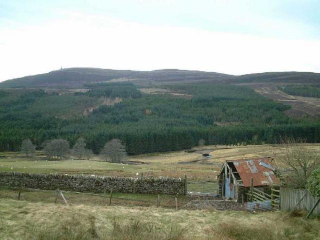
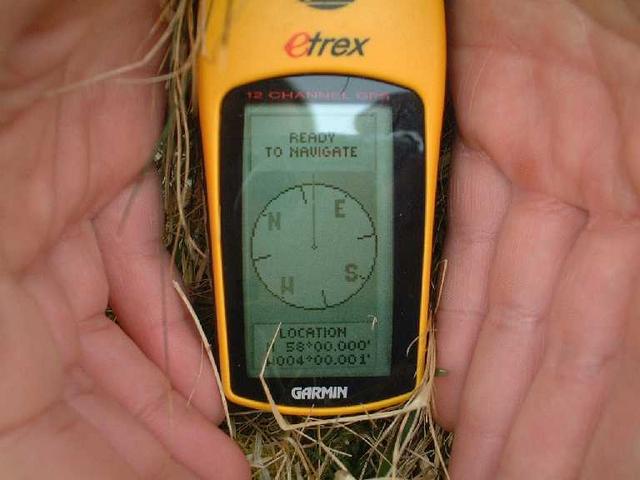
(visited by kevin watt and John Hall) 26-Mar-2002 -- Although this confluence had been visited the year before, I felt it needed spiced up a little! A few more pictures and GPS reading, stuff like that. We set off from 58N5W after the best veggie breakfast I’ve ever had (The Ceilidh Place in Ullapool, that should get me a free room the next time I’m up there!). It was a short drive over to the East Coast on a single-track road typical of this area. Yes John, you shall be a rally driver. Again, some fantastic views on the way to Golspie, the nearest town to the confluence. We followed the track beside Golspie Burn as far as we could in the car. The next step was down to the burn through a field, wet again. After a 10-minute walk we marked the spot. The views are all pretty much the same but the photos don’t really do the area justice. One point for future visitors, the OS map of the area shows the confluence to be on the south side of the river but our readings were on the north side. Even if you had to cross the river, it’s not too difficult if the water is low and you have waterproof boots on. The sheep in the field are quite friendly too. |
| All pictures |
| #1: north view #2: the GPS reading #3: east view #4: the view from the road to the confluence #5: south view #6: west view ALL: All pictures on one page |