|

Italy : Emilia-Romagna
3.3 km (2.0 miles) NE of Collina, Forli, Emilia-Romagna, Italy
Approx. altitude: 536 m
(1758 ft)
([?] maps: Google MapQuest OpenStreetMap ConfluenceNavigator)
Antipode: 44°S 168°W
Accuracy: 20 m (65 ft)
Quality: good
Click on any of the images for the full-sized picture.


| 44°N 12°E (visit #2) |
![Visit #8: [17-Oct-21]](/it/all/n44e012v8/preview.jpg "Visit #8: [17-Oct-21]")
![Visit #7: [15-Sep-18]](/it/all/n44e012v7/preview.jpg "Visit #7: [15-Sep-18]")
![Visit #5: [23-Dec-13]](/it/all/n44e012v5/preview.jpg "Visit #5: [23-Dec-13]")
![Visit #4: [24-Aug-13]](/it/all/n44e012v4/preview.jpg "Visit #4: [24-Aug-13]")
![Visit #6: [17-Jun-13]](/it/all/n44e012v6/preview.jpg "Visit #6: [17-Jun-13]")
![Visit #3: [15-May-11]](/it/all/n44e012v3/preview.jpg "Visit #3: [15-May-11]")
![Visit #1: [15-Apr-02]](/it/all/n44e012/preview.jpg "Visit #1: [15-Apr-02]")

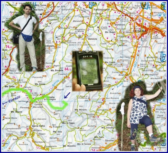
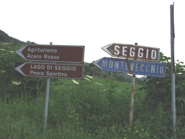
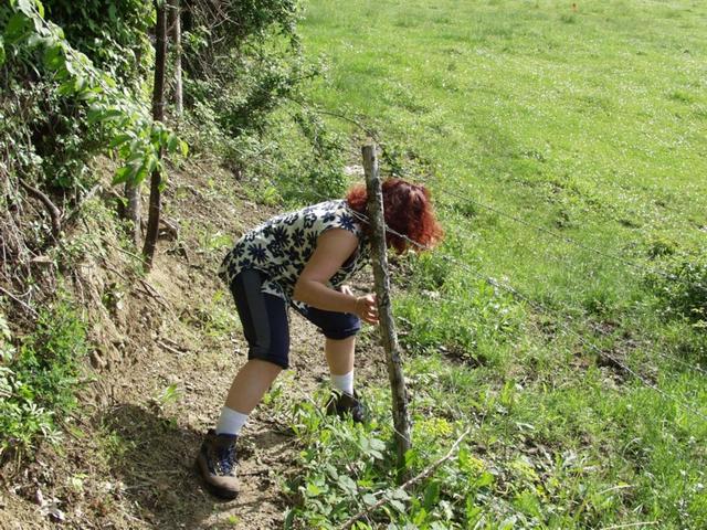
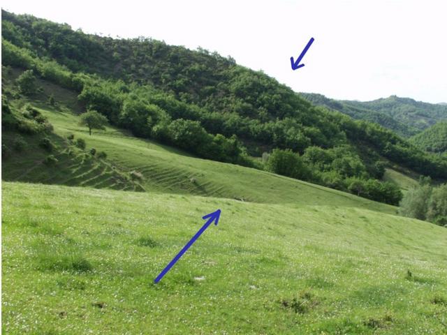
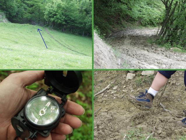
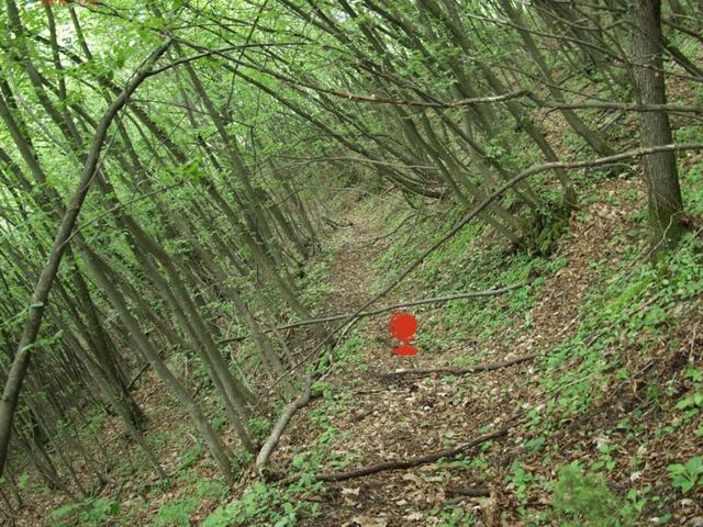
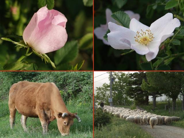
(visited by Luca Bartolini and Serena Baiocchi) 19-May-2002 -- For a couple of weeks we were studying the best way to reach the point 44°N - 12°E. A beautiful challenge! In fact as you can see by the photo the surrounding zone is absolutely deprived of roads and of urban agglomerations. The previous visit attempted by Hans Augdoppler has benefited us, let's take the occasion to thank him! The adventure is initiated in the late forenoon of Sunday May 19th 2002 to Pistoia where we have taken the highway A11 in the direction of Florence, continuing on the A1 in the direction of Rome as far as Florence-South. Here we have continued with the government road E35 crossing towns of “Pontassieve”, “Rufina”, “Dicomano” and “San Godenzo”. Here we stopped to have a fast lunch, cheered by a characteristic local market of antique-trade. Desirous to conquer the spot, we are gone up again in car and just before “passo del Muraglione” we have taken the regional road 9-ter, crossing the towns of “Premilcuore”, “Strada San Zeno”, “Galeata” for then to reach the our first target “Civitella di Romagna”. To this point we have tried to approach the spot in line of air, trusting our instinct we have taken a small steep road in direction of a sport fishing lake: “Lago di Seggio”. Not so far away the road has become a path of mountain, therefore we have parked the car and continued afoot with our tools: GPS and COMPASS. At 600 mt. from the spot we come upon a field fenced by boned thread. Nobody around us, SERENA has crossed for first the enclosure. In front of our eyes it opened a great lawn and there among the brushwood the spot. Unfortunately from there to few hundred meters the grassy mantle has left space to a mud-path. It was like walking on an expanse of glue that tried to swallow our boots. 20 meters on that seems 20 km on a road! So we have opted for climbing above for the hill, revolving the spot and therefore lengthening the journey but having salutes our shoes! Reached 552 meters s.l., at 5:57 PM, we have conquered 44°N - 12°E. To mark it, we have picked up a twig, on which we have inserted a sock. After having photographed the zone, we come back to the car. Luca however has been captured by the fauna and local flora, and immediately shoot with his digital camera: cows, sheep and a beautiful rose called “rosa di bosco”. 19-May-2002 -- Da un paio di settimane stavamo studiando il percorso migliore per raggiungere il punto 44°N - 12°E. Una bella sfida! Infatti come si può vedere dalla foto la zona circostante è assolutamente priva di strade e di agglomerati urbani. I tentavi fatti precedentemente da Hans Augdoppler ci hanno avvantaggiati, cogliamo così l'occasione per ringraziarlo! L'avventura è iniziata nella tarda mattinata di domenica 19 maggio 2002 a Pistoia dove abbiamo preso l'autostrada A11 in direzione Firenze, proseguendo sulla A1 in direzione Roma per poi uscire al casello autostradale di Firenze Sud. Qui abbiamo proseguito con la stada statale E35 incontrando i paesi di Pontassieve, Rufina, Dicomano e San Godenzo. In quest'ultimo ci siamo fermati a consumare un veloce ma gustoso pranzo, allietati da un caratteristico mercatino locale dell'antiquariato. Bramosi di conquistare lo spot siamo risaliti in auto e poco prima del Passo del Muraglione abbiamo imboccato la strada regionale 9-ter, lungo la quale abbiamo incontrato le località Premilcuore, Strada per San Zeno, Galeata per poi raggiungere il nostro primo obiettivo: Civitella di Romagna. A questo punto ci siamo avvicinati il più possibile in linea d'aria, fidandoci del nostro istinto abbiamo imboccato una piccola strada di campagna molto ripida in direzione del lago di pesca sportiva "Lago di Seggio". Salendo salendo la strada si è trasformata in un sentiero di montagna, quindi abbiamo parcheggiato l'auto e proseguito a piedi guidati questa volta dai nostri strumenti: GPS e BUSSOLA. Giunti a circa 600 mt. dal punto ci siamo imbattuti in un campo recintato da filo spinato. Non intravedendo nessuno SERENA ha varcato per prima la recinzione. Davanti ai nostri occhi si apriva un grande prato e là tra la boscaglia ci doveva essere il punto. Purtroppo da lì a poche centinaia di metri il manto erboso ha lasciato spazio ad un sentiero di mota. La sensazione era quella di camminare su una distesa di colla che tentava di ingoiarsi i nostri scarponi. 20 metri su quel terreno erano come 20 Km sulla strada! Così abbiamo optato per arrampicarci sulla collina aggirando il punto e quindi allungando il tragitto ma avendo salve le nostre scarpe! Raggiunti i 552 metri di altezza alle ore 17:57 abbiamo conquistato il 44°N - 12°E. Per segnarlo abbiamo raccolto un ramoscello a cui abbiamo infilato un calzino in punta. Dopo aver fotografato la zona, ci siamo diretti verso la nostra auto. Luca però è stato catturato dalla fauna e flora locale che ha subito immortalato con la sua macchina fotografica digitale: mucche, pecore e bellissime rose di bosco. |
| All pictures |
| #1: The spot #2: The map #3: Direction "Lago di Seggio" #4: Across the bone #5: The spot is there #6: Mud #7: Flora and fauna #8: Panoramic view ALL: All pictures on one page |