|

United Kingdom : England
3.8 km (2.4 miles) ESE of Rylstone, North Yorkshire, England, United Kingdom
Approx. altitude: 401 m
(1315 ft)
([?] maps: Google MapQuest OpenStreetMap ConfluenceNavigator)
Antipode: 54°S 178°E
Accuracy: 8 m (26 ft)
Quality: good
Click on any of the images for the full-sized picture.


| 54°N 2°W (visit #3) | (secondary) |
![Visit #18: [24-Dec-19]](/uk/en/n54w002v18/preview.jpg "Visit #18: [24-Dec-19]")
![Visit #17: [28-Apr-18]](/uk/en/n54w002v17/preview.jpg "Visit #17: [28-Apr-18]")
![Visit #16: [26-Apr-12]](/uk/en/n54w002v16/preview.jpg "Visit #16: [26-Apr-12]")
![Visit #15: [16-Apr-12]](/uk/en/n54w002v15/preview.jpg "Visit #15: [16-Apr-12]")
![Visit #13: [16-Mar-12]](/uk/en/n54w002v13/preview.jpg "Visit #13: [16-Mar-12]")
![Visit #14: [09-Mar-12]](/uk/en/n54w002v14/preview.jpg "Visit #14: [09-Mar-12]")
![Visit #12: [03-Aug-11]](/uk/en/n54w002v12/preview.jpg "Visit #12: [03-Aug-11]")
![Visit #11: [04-Jun-10]](/uk/en/n54w002v11/preview.jpg "Visit #11: [04-Jun-10]")
![Visit #10: [29-May-09]](/uk/en/n54w002v10/preview.jpg "Visit #10: [29-May-09]")
![Visit #9: [29-May-09]](/uk/en/n54w002v9/preview.jpg "Visit #9: [29-May-09]")
![Visit #8: [13-Jan-09]](/uk/en/n54w002v8/preview.jpg "Visit #8: [13-Jan-09]")
![Visit #7: [14-Jul-08]](/uk/en/n54w002v7/preview.jpg "Visit #7: [14-Jul-08]")
![Visit #5: [08-Jun-04]](/uk/en/n54w002v5/preview.jpg "Visit #5: [08-Jun-04]")
![Visit #6: [08-Jun-04]](/uk/en/n54w002v6/preview.jpg "Visit #6: [08-Jun-04]")
![Visit #4: [07-Jan-04]](/uk/en/n54w002v4/preview.jpg "Visit #4: [07-Jan-04]")
![Visit #2: [03-May-02]](/uk/en/n54w002v2/preview.jpg "Visit #2: [03-May-02]")
![Visit #1: [14-Jun-00]](/uk/en/n54w002/preview.jpg "Visit #1: [14-Jun-00]")

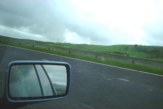
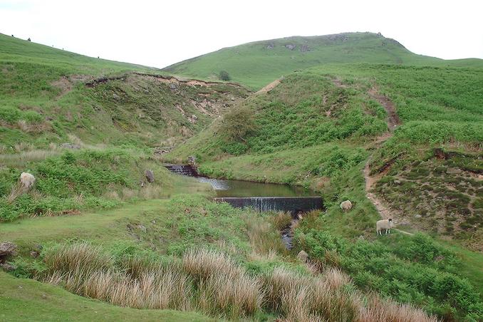
(visited by Gordon Spence) 18-Jun-2002 -- Buoyed up by my earlier success today at 55N 3W where I completed all the land-based points in the UK I decided to take in a detour on the way home to complete the only other point in England North of my home that I had yet to visit. I came South via the more usual route of the M6 motorway, one because it is quicker, but mainly becuase I knew that there was something interesting to stop and look at on the way.... ....from the motorway you can see (Pic 3) this tantalising glimpse. Exit the motorway at Junction 37, turn right and drive 300 yards, parking on the right in front of the gates to this (Pic 4). It is one of a few in the UK, more details can be found here The site produces around 6.5MW and can provide power for around 4000 homes. The gate is locked but there are no keep out signs, I was tempted to take a closer look. This statement is on their web site "NOTE: National Wind Power Ltd accepts no liability for any loss or damage to vehicles or property or any injury to persons whilst visiting their wind farms. Please note that children and dogs must be supervised by adults at all times" which seems to suggest that visitors are welcome. Leaving this glimpse into the future I returned to the M6, down one more junction and took the A65 towards Skipton, approaching from the NW. this way I avoided the nightmare roadworks that Hans mentioned. It is a nice scenic drive down the A65, lots of sweeping curves and small crests. Very pleasant. I arrived in Embsay and found the car park on the main street. Funny, it didn't look like the car park from the previous reports and it was also full. It was at this point that I noticed the pointer to another car-park a mile away, and in the direction that took me closer to the CP. Follow the road and behold, a car-park with only two other cars in it. Parking up I prepared for the trek to the CP. Mindful of Hans note about the boggy areas I had brought my Wellies with me. I went the opposite way around the reservoir this time and took a picture from the opposite end (Pic 5). Continuing on around brought me to the entry point (Pic 6) to the route in. What looks to be a failry innocuous grass covered slope is in fact a 1-in-3 hill covered with waist high ferns, extremely difficult to make your way through. Once you get through this you then come to knee high heather instead, not much easier going. Now I suspect that not many people get up around here, I came across this little resident (Pic 7), who just sat there looking at me, curiously. Mindful that I was in his territory I slowly and carefully backed off and tracked around him. Now sometimes you know, the eye is better than the machine. I stopped nearly at the top of the hill and looked back (Pic 8). What I have circled (it is much clearer in the individual photo) is in fact another wind-farm! Now this is facing south-east, doesn't belong to the National Windpower, wonder who owns it? Using the quick formula of square-root (height in feet) * 1.23 equals distance to horizon in miles, knowing I was at about 1200 feet gives a maximum distance away of roughly 42 miles. I turned and continued on, things suddenly got much greener and lusher, I didn't cotton on immediately that this meant water and plenty of it, too busy concentrating on the GPS...until I sunk up to me knee in smelly brown water. Oh well, reminds me of 55N 5W I located the exact spot and took the Looking North shot (Pic 1) and the GPS shots (Pic 2). If you are reading this Hans the skeleton is still there! The return downhill was easier than the climb up - only just, waist high vegetation is diffcult either way! I finally arrived home at 9pm, 16 hours and 616 miles after leaving. A very satisfying day, I have only four more points to visit before I have personally completed the whole of England. Wonder how long I can hold out before again hearing "the call of the wild".... |
| All pictures |
| #1: Looking North #2: GPS montage #3: Tantalising glimpse #4: Wind Farm #5: Reservoir from the other end #6: It's up there somewhere #7: A local resident #8: E-S-W Panorama ALL: All pictures on one page |
| Notes |
|
In the Yorkshire Dales National Park. |