|

Benin
5.9 km (3.7 miles) SSE of Koutago, Collines, Benin
Approx. altitude: 161 m
(528 ft)
([?] maps: Google MapQuest OpenStreetMap ConfluenceNavigator)
Antipode: 8°S 178°W
Accuracy: 6 m (19 ft)
Quality: good
Click on any of the images for the full-sized picture.


| 8°N 2°E (visit #1) |
![Visit #2: [14-Feb-08]](/bj/all/n08e002v2/preview.jpg "Visit #2: [14-Feb-08]")

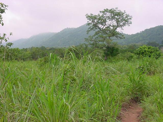
(visited by J. Baker Hill) 07-Aug-2002 -- I had to make a trip south by road from Niamey, Niger, to Cotonou, Benin (about 1100 km). A few months ago I had traversed Benin on both sides and found the first confluence point near the northern border with Burkina Faso (11N 1E). On the way north because of time constraints I had passed up one confluence, 8N 2E, north of the mountain town of Savalou and just east of the village of Boyissa. But I still had it in my mind to get this one, too, if possible. On my way down it would be slightly out of the way (about 30 kilometers off my route) but since I was travelling alone, this, I thought, would not be a deterrent. I was also going to take two days for the trip and thus should have plenty of time to look for the Confluence. However, just before leaving I agreed to take two Nigeriens down with me, and this would complicate things. The first day we made it to Dassa-Zoumé, just 200 kilometers from Cotonou, and conveniently located just 30-odd kilometers from my target Confluence. We found an "auberge" for the night, for about $7 a room. Accommodations included a bed with foam mattress, a floor fan, screens on the windows and a mosquito net, but no towels, soap, top sheet, toilet paper or toilet seat! There was also a restaurant that offered "bush meat" including antelope and agouti, which is a large rodent about the size of a beaver. Agouti was my choice and it was quite tasty. The only problem was that they had used a cleaver to chop it up and there were quite a few bone fragments, one of which found a weak molar I had and broke half of it off. Fortunately it was not painful. We went to bed and I found I had bedbugs, so got back up and put on all my clothes to defend somewhat against the critters and was able to sleep reasonably well. I told my travelling companions I would go out early in the morning for some "tourism" and come back around 9, at which time we would head south for Cotonou. I did not feel like trying to explain what I was doing! I arose at 5:30 and showered, towelling off with my shirt, then headed out northwest towards Savalou, which the GPS said was 32 km distant, at around 6:30, which was about daybreak. The sky was full of lowering clouds, brushing the tops of the low granite mountains, and I was concerned it might rain. The road to Savalou was under construction so it was slow going and took nearly an hour to arrive at Boyissa. At this point there was a construction detour which I remembered from my trip in March, which led quite far off the main road to the east in the direction of the Confluence. However, at its closest point the GPS read 1.35 kilometers and there was no more road available. I hunted around a little and found a narrow farm trail leading through the thick bush, heading straight for the Confluence. Thinking it too good to be true, I started hiking at a fast pace, not knowing how many twists and turns I would have to make. The weather was cool, although humid, and the tall grass was wet and leaning into the trail, soaking my shoes and trousers. I was weaving through farms where they were growing corn, manioc (cassava), beans and peanuts, and there were quite a few palm trees scattered about as well as teak. The trail was going to have to lead pretty close to the Confluence due to the thick undergrowth and my fear of snakes. I came abreast of the Confluence at 300 meters distance after doing about 1.6 total kilometers and could see no way to reach it. I decided to continue on just a little to look for a trail, and sure enough, there was one! It led to within 60 meters and then there was a corn and peanut field that looked like it would be easy to traverse. This done, I was within ten meters of the Confluence, located in the shade of a large teak tree. I gingerly trod down the tall grass, watching for snakes, until I could stand on the Confluence and under the tree. Unfortunately due to the broad teak leaves I could not get the GPS to read the zeros and needed to head back. I got off a few shots of the surrounding scenery, which was much better-looking than my average luck in West Africa to this point. As I approached where I had left the car I could hear the crowing roosters and general bustle of the village of Boyissa, located on the side of the mountain to the west of the main road. I turned around and headed back. At one of the construction sites some of the workers were having a fight and tossing large stones at each other. I was not sure when I would get through as I was surely not going to try and cross the site with 10 or 12 angry people throwing rocks! They looked like they were intent on killing one worker, but after a few minutes and a line of traffic on both sides they decided to call it off and let us through. I arrived back at the auberge just after nine and we continued on down to Cotonou, arriving at about noon with one more Confluence under my belt. |
| All pictures |
| #1: The teak tree growing out of 8N 2E #2: A view of the mountain southwest of the point #3: A small palm tree northwest of the point #4: The GPS showing my track and the distance from the main road ALL: All pictures on one page |