|
Canada : British Columbia
105.7 km (65.6 miles) N of Premier, BC, Canada
Approx. altitude: 1492 m
(4894 ft)
([?] maps: Google MapQuest OpenStreetMap topo topo250 ConfluenceNavigator)
Antipode: 57°S 50°E
Accuracy: 15.7 km (9.7 mi)
Quality: good
Click on any of the images for the full-sized picture.
| 57°N 130°W | (incomplete) |

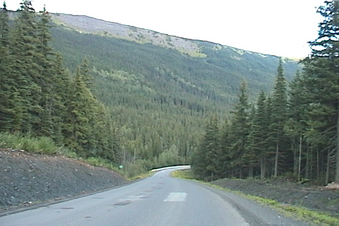
(visited by Dave Patton) During August 2003 I drove through British Columbia and into the Northwest Territories on a combined confluence hunting and sightseeing trip. I started close to 49°N and went as far North as 61°N, covered 6,200 kilometers (3,850 miles), did 7 successful confluence visits, and had another 12 confluences that are incomplete. I made a map that shows the route, and the confluences in the order they were done, with the successful ones shown with black markers. The incomplete visits are a mix of actual attempts and situations where I drove somewhat close to the confluence, and included a 'visit' as a way to document the confluence location for future visitors. The first confluence on the trip was 52°N 121°W. 18-Aug-2003 -- After my incomplete "visit" to 59°N 130°W I continued south on the Stewart-Cassiar Highway (Highway 37). I stopped in Dease Lake to get gas, and dinner. A couple of hours later, I was at 57°N. Just before that, I took a picture looking east, towards the confluence, which is 15.67 kilometers away, in rugged terrain. As I continued along the highway I took a couple of photos of the views, and as I got closer to 130°W, I took another photo to show the terrain in the area. The heavy rain from earlier in the day had stopped some hours prior, but in this area I started to get some showers again. This was the last confluence "visit" on this trip. It was approaching 9:00PM as left the area of this confluence, and I continued driving south on the Stewart-Cassiar highway. Just before 11:00PM I arrived at Meziadin Junction. This is the the junction of Highway 37, and Highway 37A, which goes to Stewart, BC, which is on the BC - Alaska border, next to Hyder, Alaska, which is the only community in southern Alaska accessible by road. My only problem was that although I had already done a lot of driving today, I was wide awake, and wanted to continue, but wasn't sure if I could make it to Kitwanga, at the Highway 37 - Highway 16 junction, without getting more gas. The gas station at Meziadin Junction was closed, and I didn't know where the next one was located. As I was pondering what to do, an '18-wheeler' truck drove up the road from the south. I asked the driver whether there were any gas stations between here and Kitwanga, and he said the nearest was in Kitwanga, but it would be closed. He said I could drive to Stewart, but that gas station would also be closed! I decided to drive further south, and after about 50 kilometers, I turned off onto a logging road and found a place to 'camp'(i.e. sleep in the car) for the night. It was 11:30PM. 19-Aug-2003 -- Shortly after 6AM I continued south, only to find that when I got to the gas station at Kitwanga, it was closed! It was 7:05AM, and it turns out the station doesn't open until 7:30AM. Once I filled up with gas, I left Kitwanga, and then headed south on Highway 16 to Prince George, then on Highway 97 to Cache Creek, then Highway 1 to Vancouver, arriving home just after 11PM. Since leaving the Beaver Lake recreation site on the morning of the 17th, after putting on my spare tire, I covered 2,732 kilometers in just over 60 hours, which includes time spent getting a new tire in Fort Nelson, rest stops, eating, sleeping, and stops to look at the scenery and take pictures. It had been a long couple of days, and I was glad to be home - it had been an interesting trip :-) |
| All pictures |
| #1: east, towards confluence, from highway #2: just past Echo Lake, looking ENE #3: view from highway, below 57°N, facing West #4: view from highway, below 57°N, facing SSE #5: Yukon Telegraph sign #6: NASA Landsat satellite image (early 1990s) ALL: All pictures on one page |


