|
United States : New York
2.8 miles (4.5 km) N of Miller Place, Suffolk, NY, USA
Approx. altitude: 0 m
(0 ft)
([?] maps: Google MapQuest OpenStreetMap topo aerial ConfluenceNavigator)
Antipode: 41°S 107°E
Accuracy: 25 m (82 ft)
Quality: good
Click on any of the images for the full-sized picture.
| 41°N 73°W (visit #2) |

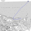
(visited by David Manthey) 15-Jul-2001 -- After a failed attempt on 41°N 72°W, I drove west to the town of Cedar Beach to try 41°N 73°W. I drove around a little trying to see if there was a better put-in than I had used on my first attempt. The first attempt had failed only due to a lack of time, and today I had plenty of it. Not finding a better spot, I drove down Harbor Beach Road to the turn-out I had used a month ago, and parked my car. Just after I arrived at the turnout, a van with two middle-aged men (and fishing gear) arrived. They waxed enthusiastic over my canoe (the Dog Sally is a nice boat), and were very keen on the whole confluence idea. They wished me well as I departed. As before, it was a short walk down to the water. The tide was just starting to ebb, and there was a west-northwest wind. The wind made for a bit more chop that my first attempt, but nothing to be concerned about. I launched my canoe and set out. My launch time was about 9:30 a.m. Going through the harbor was easy; not many people were boating at this hour, and those that were out were obeying the navigation regulations. I pulled out into Long Island Sound, where the waves were larger but spaced far apart. At the largest, the waves were close to two feet in size, but never any trouble. I headed almost directly to the confluence (see map), which went quickly. Both the wind and the tide aided the trip, even with the waves striking my port bow. There were lots of fishing vessels to be seen, plus quite a few lobster buoys. As I neared the confluence, I could see a freighter crossing the Sound in the distance. Although there was nothing in particular at 41°N 73°W, it is a nice spot of water. I took photographs, and managed to drift a tenth of a mile while doing so. I then paddled back and forth until I was certain I had taken a picture showing the GPS at all zeroes. This was easier than I had anticipated, even though it took a few tries. The weather was clear and I could see features in almost all directions. There are beaches and Long Island all along the south, and the Connecticut shore all along the north. To the southwest Port Jefferson is just beyond a spit of land, to the northeast there is a small lighthouse, and to the north there is Bridgeport, Connecticut. In all directions, one could see boats, mostly recreation sailboats and motorboats. The return trip was vastly more effort, as the tide was in full rip. On the way out to the confluence, I averaged well over four miles per hour while feeling like I was loafing along. On the way back I averaged closer to 2.5 miles per hour, and I was working hard. It was a lovely trip, except that as I was reentering the harbor a motorboat ran down the channel outside of its proper navigation lane at about 15 mph. Being less than a boat length away from me, its wake dumped a half gallon of water into my canoe. Rude fellow. I got back to my put in around 1 p.m., having covered a total distance of 10 miles. The tide was now mostly out, making it look quite different from when I launched. I took a few photographs of my canoe, then returned to my car. I drove back via New York City, and the traffic was surprisingly light the whole way home. |
| All pictures |
| #1: The view west from the confluence. This is looking up Long Island Sound. #2: This freighter crossed in front of me. #3: Bridgeport, Connecticut, visible to the north. #4: The view south, looking at the Long Island shore. #5: The GPS at 41°N 73°W. #6: My canoe at the take-out point. #7: Map with track log ALL: All pictures on one page |
| Notes |
|
In the Long Island Sound, about 2.3 mi from Long Island's shore. |


![Visit #3: [28-Jun-22] Visit #3: [28-Jun-22]](/us/ny/n41w073v3/preview.jpg)
![Visit #1: [15-Jun-01] Visit #1: [15-Jun-01]](/us/ny/n41w073/preview.jpg)