|
Sweden
2.1 km (1.3 miles) SSW of Hommanbodarna, Dalarna, Sweden
Approx. altitude: 301 m
(987 ft)
([?] maps: Google MapQuest OpenStreetMap ConfluenceNavigator)
Antipode: 61°S 165°W
Accuracy: 4 m (13 ft)
Quality:
Click on any of the images for the full-sized picture.
| 61°N 15°E (visit #5) |
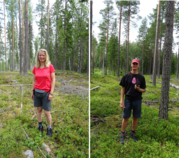
 (visited by Karl Bryk and Heidi Peschl) 19-Jul-2019 -- This the second of 3 CP visits during our annual trip to Sweden.
The previous was N61 E17. |
| All pictures |
| #1: Overview #2: North #3: East #4: South #5: West #6: GPS #7: Visitors ALL: All pictures on one page |


![Visit #6: [05-Jul-21] Visit #6: [05-Jul-21]](/se/all/n61e015v6/preview.jpg)
![Visit #3: [11-Jul-11] Visit #3: [11-Jul-11]](/se/all/n61e015v3/preview.jpg)
![Visit #4: [06-Aug-08] Visit #4: [06-Aug-08]](/se/all/n61e015v4/preview.jpg)
![Visit #2: [12-Sep-07] Visit #2: [12-Sep-07]](/se/all/n61e015v2/preview.jpg)
![Visit #1: [26-May-01] Visit #1: [26-May-01]](/se/all/n61e015/preview.jpg)