|

Romania
1.3 km (0.8 miles) E of Păuleşti, Prahova, Romania
Approx. altitude: 216 m
(708 ft)
([?] maps: Google MapQuest OpenStreetMap ConfluenceNavigator)
Antipode: 45°S 154°W
Accuracy: 90 m (295 ft)
Quality: good
Click on any of the images for the full-sized picture.


| 45°N 26°E (visit #1) |
![Visit #2: [17-Apr-12]](/ro/all/n45e026v2/preview.jpg "Visit #2: [17-Apr-12]")

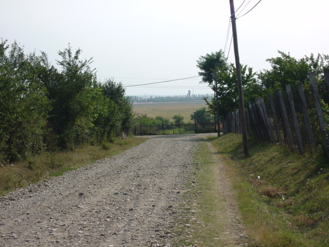
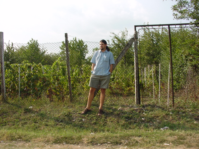
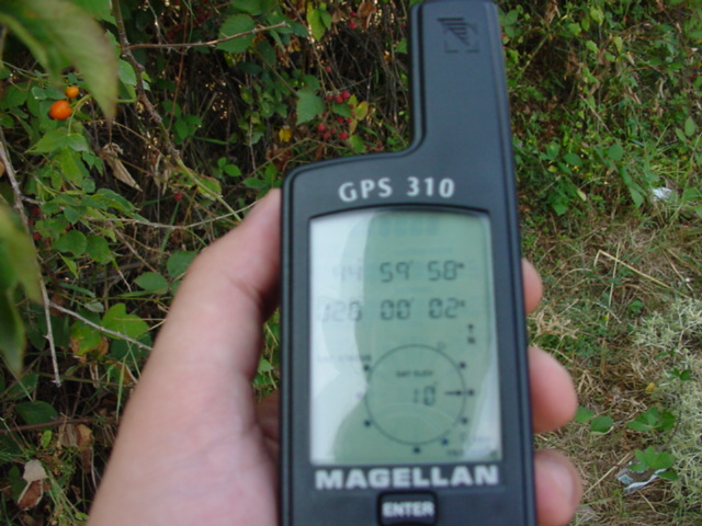
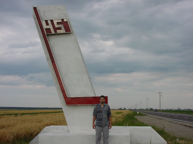
(visited by Mihai Pitigoi, Andra Costin, Mihnea Costin and Carmen Stroe) 26-Aug-2001 -- English - I’m happy I didn’t start my confluence experience with this one! It was too easy, but it was nothing interesting about it and we couldn’t reach all the zeros either, so overall I hope none of my future confluences would be like this one. We left Bucharest in the afternoon, the same party that visited the first Romanian confluence, N44 E26. We drove north, to Ploiesti, and after crossing this city we entered the village of Blejoi, 3 kilometers from Ploiesti. We got there in 50 minutes. The GPS showed some 2 kilometers to the confluence point, which seemed to be once again in a cornfield. We left the main road and turned left on a dirt road, trying to get the closest we could to the confluence. After a while we were driving by a cornfield, but we entered again the village. After turning left and right for many times, still on dirt roads, we realized that the confluence point was exactly in the village, probably in somebody’s yard. After driving two times on each road next to the confluence to conclude where it was and how we could reach it, we found that the nearest spot, just 90 meters away (photo #2, sorry for the bad quality), was on a road that had no houses on it, only small enclosed vineyards and gardens, probably owned by people in that village. There was no open gate and nobody to ask permission, and we didn’t want to jump over the fences and get into trouble, so we took the pictures here. The spot wasn’t too interesting. Only westwards I could get a picture showing something else than fences (photo #1). The confluence was northwards, just 90 meters behind me in photo #3. The elevation was about 220 meters. I also took a picture of the best GPS reading I could get (photo #4), once again sorry for the bad quality. Overall, it seemed like a bad day for confluences. Besides that we couldn’t reach the exact spot, we didn’t even get to walk, the surroundings were totally not interesting, and I missed both GPS pics. I included, finding it of some interest, a picture taken two months ago, with the confluence project in mind (photo #5). I was driving to the mountains, on the road linking Bucharest to Transylvania, and stopped by the monument marking the spot where 45N (the perfect half of the northern hemisphere) crosses the road. This is just 20 kilometers from the confluence. 26-Aug-2001 -- Romana - Bine ca nu am inceput vizitarea confluentelor cu asta! A fost usor de ajuns, dar peisajul era ca si inexistent si in plus nici nu am atins punctul exact. Intr-un cuvint, sper sa nu mai fie si altele la fel. Am plecat din Bucuresti dupa-amiaza, in aceeasi formula ca si la 44N 26E. Am pornit spre Ploiesti, am trecut prin oras si am ajuns la Blejoi (la vreo 3 km mai incolo, spre Valeni). Pina aici am facut 50 minute. GPS-ul arata inca 2 km pina la confluenta, care parea sa fie iar in porumb. Am facut stinga pe o ulita din Blejoi, asfaltata cu bolovani, pina am iesit in cimp. Am mers in continuare cu masina, incercind sa ne apropiem cit mai mult de confluenta. Dupa o bucata, am intrat iar in sat. Dupa ce am facut stinga-dreapta o vreme pe tot felul de ulite, ne-am dat seama ca punctul cautat era exact in sat, pesemne in vreo curte. Ne-am invirtit pe toate ulitele din jurul confluentei ca sa gasim locul cel mai apropiat, si l-am gasit pe o ulita care nu avea nici macar o casa pe ea. De aici mai aveam inca 90 metri (foto 2, scuze pentru neclaritate). In directia respectiva erau vii si gradini ingradite, dar nici o casa in curti. Nu era nici o poarta deschisa si nimeni caruia sa-i cerem permisiunea de a trece de gard, asa ca ne-am multumit cu locul asta pentru poze. Peisajul nu era prea interesant. Numai spre vest am putut fotografia altceva decit garduri (foto 1). Confluenta era inspre nord, la 90 m in spatele meu (foto 3). Altitudinea era de 220 m. Am facut si o poza la GPS, cu cea mai buna indicatie pe care a afisat-o (foto 4). Din nou scuze pentru neclaritate. Per total, a fost o zi cu ghinion pentru confluente. Pe linga faptul ca nu am atins punctul exact, nici macar nu am mers 10 metri pe jos, peisajul era neinteresant si am ratat si amindoua pozele cu afisajul GPS-ului. Am inclus si o poza de acum doua luni, pe care am facut-o tot pentru proiectul acesta (foto 5), anume o poza de la monumentul de pe soseaua spre Brasov, care se afla la doar 20 km de confluenta. |
| All pictures |
| #1: View westward/Vedere spre vest #2: 90 more meters/Inca 90 metri #3: Only a few feet away/La 2 pasi #4: Closest approach/Mai aproape nu am reusit sa ajungem #5: Halfway between 0 and N90/Jumatatea emisferei nordice ALL: All pictures on one page |