|

Canada : British Columbia
33.1 km (20.6 miles) WSW of Falls Creek, BC, Canada
Approx. altitude: 894 m
(2933 ft)
([?] maps: Google MapQuest OpenStreetMap topo topo250 ConfluenceNavigator)
Antipode: 50°S 58°E
Accuracy: 5.5 km (3.4 mi)
Quality: good
Click on any of the images for the full-sized picture.


| 50°N 122°W (visit #1) | (secondary, incomplete) |
![Visit #2: [31-May-02]](/ca/bc/n50w122v2/preview.jpg "Visit #2: [31-May-02]")

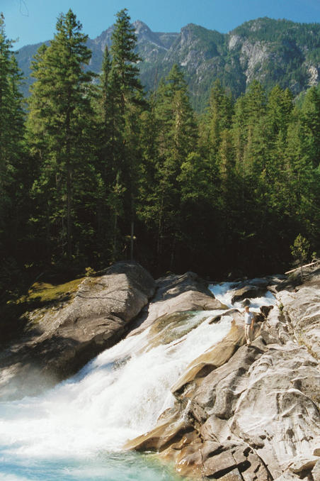
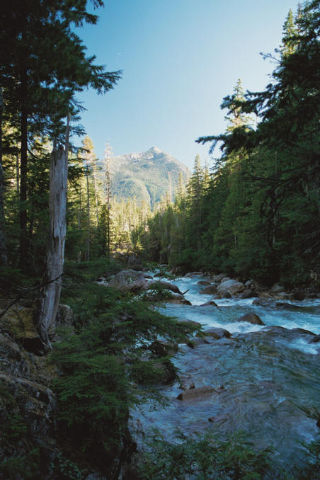
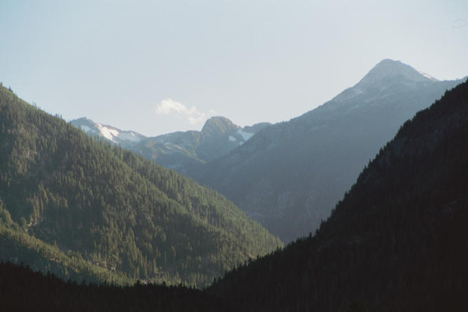
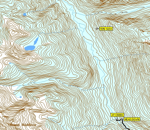
(visited by Dave Patton, Tim Dinsdale and Chris Nuttall-Smith) 08-Sep-2001 -- Dave's narrative: At the end of August, I was contacted by an editor from a local newspaper, The Vancouver Sun, in regards to information about the Degree Confluence Project. After a couple of emails with the editor, a reporter from the Sun, Chris Nuttall-Smith, contacted me. Chris was interested in gathering information so he could do a story, and wanted to meet and talk about the project, but he also was hoping to go on a confluence hunt. In addition, I said that I would try and arrange for him to be able to talk to another local confluence hunter, Tim Dinsdale. The combination of our schedules and the weather led to the idea of the three of us making an attempt at 50N 122W. None of us had met before, or been to the confluence area, but a few phone calls later, we had a plan to set off from Vancouver on Saturday morning. We left Vancouver about 8AM, drove through the Fraser Valley to Hope, then drove up the Fraser Canyon to Boston Bar. In Boston Bar we turned west off Highway 1 towards North Bend, crossed over the Fraser River, and headed for Nahatlatch Provincial Park. Once we reached Nahatlatch Park, we continued along the Nahatlatch Forest Service Road, eventually reaching a bridge with a locked gate at 48km. The 50N 122W confluence is located in Mehatl Creek Provincial Park, which is one of BC's newer parks. Information from the parks service indicated that the park is "undeveloped, isolated, and has no signposts or trail guides", and that the park, which comprises the entire Mehatl Creek drainage, is "prime habitat for grizzly bears, black bears, and cougars". There is one trail in the park, which leads from the road next to the 48km bridge to a series of waterfalls on Mehatl Creek. A few hundred feet before the bridge is a large clearing beside the road, and from this clearing leads an old logging road, which is also the start of the trail (waypoint MAIN ROAD). Having a 4WD vehicle, we opted to drive this road. A ways down the old road, we came to a spot where we had to stop, as there is a pond that has blocked the road (waypoint CAR). At 12:45PM we set out on foot on a trail that starts on the uphill side of the road, just where it meets the pond. The trail skirts the pond, ends up back on the old road, and after heading downhill a bit, turns back into a regular hiking trail in the trees. After a pleasant hike, we reached the start of the falls at 1:35PM (waypoint LOWERFALLS, Picture #1). We continued up the trail a little ways, reaching the upper falls (waypoint UPPERFALLS), which is the end of the trail. From that point onwards, reaching the confluence requires bushwacking. We could see from the topographic maps that the Mehatl Creek valley was fairly narrow and steep in the area above the upper falls, so we headed off through the trees on a diagonal path to gain some elevation as we went upstream. Once we felt we were high enough, we continued up the valley, staying at roughly the same elevation. The hiking was not difficult, but there were places where the underbrush was thicker, such as where small streams came down the hillside, and we were hiking along a constant slope, the angle of which varied from almost flat in places to quite steep in others. At 3:05PM, at a rest stop, we knew that given the time of day and that we were still 6.5km away, we were not going to be able to make it to the confluence today. We decided to hike for about another hour, in part in hopes of getting a good view up the valley towards the confluence - maybe we could say we saw it, even if we didn't get there! It turned out that we didn't get a clear view up the valley - not surprisingly, views were limited by being in the trees, with occasional glimpses of parts of the valley. Just after 4PM we decided to go no further (waypoint HEAD DOWN). We were on a slope above Mehatl Creek, which is where Picture #2 was taken. It is looking west across the creek valley, and you can see in the picture the smaller valley on the opposite hillside created by the stream from the small lakes that can be seen on the map. We went downhill to the creek, ending up at a pleasant flat open area just above the creek (waypoint AT CREEK). On the other side of the creek the small stream from the small lakes enters Mehatl Creek, which is where Picture #3 and Picture #4 were taken. At about 4:30PM we headed back, initially staying down lower towards the creek than on our way in, but eventually ending up back at the same elevation as our hike in, and retracing our steps. Just before we reached the top of the upper falls, I took Picture #5, at 6PM, which is looking up the Nahatlatch River valley. We didn't stop much on the hike back, and reached the car at 7:25PM. We managed to drive back to Hope before the Dairy Queen closed, for some welcome food and refreshments. By the time we got back into Vancouver, it was approaching midnight. Even though we didn't reach the confluence, it was nice to get out for a hike, especially to an area that none of us had visited before. It is unknown whether it is possible to reach the confluence as a day hike, even with starting earlier (e.g. by camping the night before at Nahatlatch Park). Map 1 shows the waypoints and tracklog for our hike. Map 2 shows the confluence relative to where we reached. The AT CREEK waypoint, our closest approach, is still 5.52km from the confluence, and we don't know how easy or difficult the bushwacking would from there to the confluence. Coordinator's Note: Chris ended up being assigned other projects, so the Sun had another reporter do a story about the Project. |
| All pictures |
| #1: Lower Mehatl Creek Falls #2: Valley above Mehatl Creek #3: Mehatl Creek #4: Creek flowing into Mehatl Creek #5: Nahatlatch River valley #6: Map 1 showing waypoints and tracklog #7: Map 2 showing confluence ALL: All pictures on one page |