|

Saudi Arabia : al-Šarqiyya
5.5 km (3.4 miles) ENE of al-`Ubayla, al-Šarqiyya, Saudi Arabia
Approx. altitude: 121 m
(396 ft)
([?] maps: Google MapQuest OpenStreetMap ConfluenceNavigator)
Antipode: 22°S 129°W
Quality: good
Click on any of the images for the full-sized picture.


| 22°N 51°E |

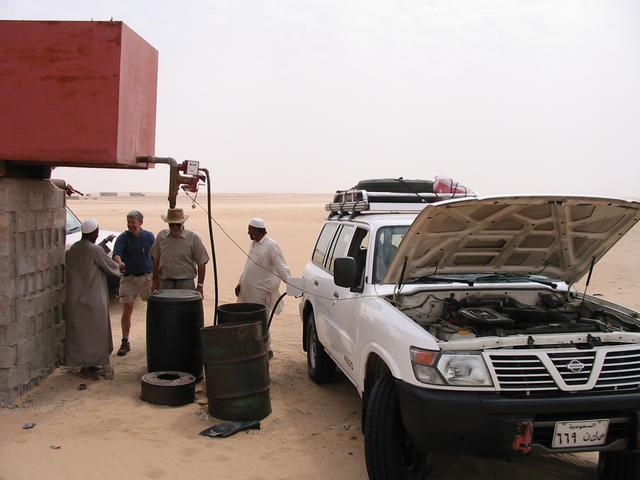
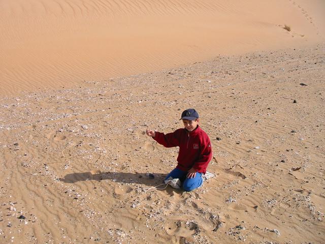
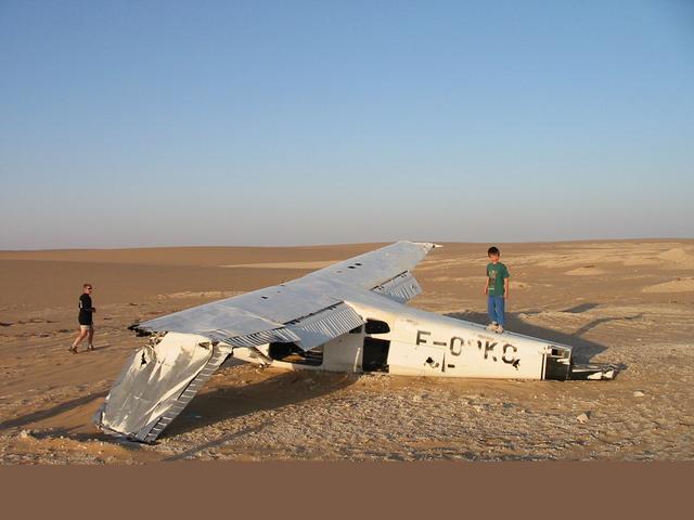
(visited by Alistair Rausch, Zander Rausch, Axel Nelms, Sylvia Nelms, Doug Mackie and Gwen Mackie) 17-Feb-2002 -- For a number of years, while the moving `Īd religious holidays have fallen in the winter season, lovers of Saudi Arabia's desert countryside have taken the opportunity to organise 4x4 holidays to the less accessible areas. This `Īd (Ḥajj 1422 = February 2002) a group of us planned a trip to near the mid-point of the Empty Quarter (the country sized Rub` al-Khāliy desert). This was to include approximately 800 km of tar-road driving and 800 km of off-road driving. We'd recently become aware of the Degree Confluence Project and altered our route to take in up to 4 confluence points, if things went well. Alistair led the convoy to this confluence point and wrote up this part of the journey. For an account of the other confluence points that we visited, see 22N 50E, 23N 51E and 24N 49E. Having conquered the 22N 50E degree confluence, we headed south for Šalfa. This was not too easy as we had to extract ourselves from an area of very soft sand. En route we encountered a group of about ten Saudi men who had journeyed to this remote location to hone their falconry skills. The five, or so, falcons seemed very well kept and waited patiently on their perches, each with a little leather head cover. The falconers were very friendly and insisted on providing photographic opportunities consisting of themselves, their falcons and their weaponry. After politely refusing the Saudi hospitality that was kindly offered, we continued overland on our journey. Šalfa is a small water station about 150 km from the nearest tar road, which offers some basic provisions for sale, as well as fuel (sometimes!). Fortunately, they had fuel on this occasion. We were intrigued with the fuel pump. This was a small 12 Volt electric pump, which needed to be connected to the battery of the vehicle receiving the fuel. The station keepers (an Ethiopian and an Indian) were adamant that we should have tea with them. As company is scarce in this remote area, we obliged and spent a pleasant hour communicating in broken Arabic, English and hand signals, while sipping the sweet Arabic tea. With filled fuel tanks we confidently set off towards our next destination, about 60 km away. We initially travelled along an old gravel "rig road" which was built to allow the heavy oil/gas exploration drilling-rigs to penetrate the sandy areas. This road was pretty old, as evidenced by the many sand dunes that have encroached onto the road in places. These dunes were very soft at times and tested our vehicles as well as our sand driving skills. We left the road after about fifteen kilometres and headed overland across undulating sand sparsely populated with desert vegetation. One puncture interrupted an otherwise pleasant roam across the sand. Our ultimate destination was the meteorite impact site known as the Wabar (or al-Ḥadīda) Crater which was first discovered by Bertram Thomas and then in 1932 by Philby. This is one of the few known iron meteorite collisions with Earth and is unique in that it is the only one that impacted with sand. Having arrived late in the afternoon, we set up camp and waited impatiently for the morning explorations. At daybreak we wandered around the site and found many examples of the tektites (small pieces of glass that was the result of the Hiroshima sized impact blast melting the sand, ejecting it into the air, and the glass solidifying into various shapes on its descent), metamorphic limestone (caused by the pressure and heat of the explosion), rusty cracked balls of iron mixed with sand/glass, and a few examples of small iron nuggets. Reluctantly, we forced ourselves to depart for the next 60 kilometre leg of our journey. We drove over a similar sandy landscape as we did on our inward journey. We searched for, and found, the ancient water well of Umm al-Ḥadīd. This well is still used today but, after some years of poor rainfalls, was deserted except for the bundles of possessions left half buried by the nomadic Bedouin tribesmen. We pressed on through the sand to al-`Ubayla. This is an old uninhabited weather station fed by another old "rig road" from the north. The dilapidated ruins, wrecked vintage vehicles and crashed aeroplane told us that this station has been out of commission for some time. As the day was drawing to a close, we found a suitable campsite that offered some protection from the wind-propelled sand. The following day we made for the degree confluence point, which was only about five kilometres from our night stop. We found it easily enough as it was located on one of the gently undulating sand rises. As with most of the degree confluence points that I have visited in Saudi Arabia, this site was scenically unremarkable. However, we were in the middle of the largest sand desert in the world and our journey to reach this remote confluence was indeed, remarkable. |
| All pictures |
| #1: Miles and miles of sand. #2: Birds of a feather flock together. #3: High technology gas station. #4: Playing in a field of meteorite tektites. #5: The original "Flight of the Phoenix". #6: The explorers. ALL: All pictures on one page |