|

South Africa : Eastern Cape
24.6 km (15.3 miles) W of Tarkastad, Eastern Cape, South Africa
Approx. altitude: 1129 m
(3704 ft)
([?] maps: Google MapQuest OpenStreetMap ConfluenceNavigator)
Antipode: 32°N 154°W
Accuracy: 1.3 km (1432 yd)
Quality: good
Click on any of the images for the full-sized picture.


| 32°S 26°E (visit #1) | (incomplete) |
![Visit #2: [15-Feb-04]](/za/all/s32e026v2/preview.jpg "Visit #2: [15-Feb-04]")

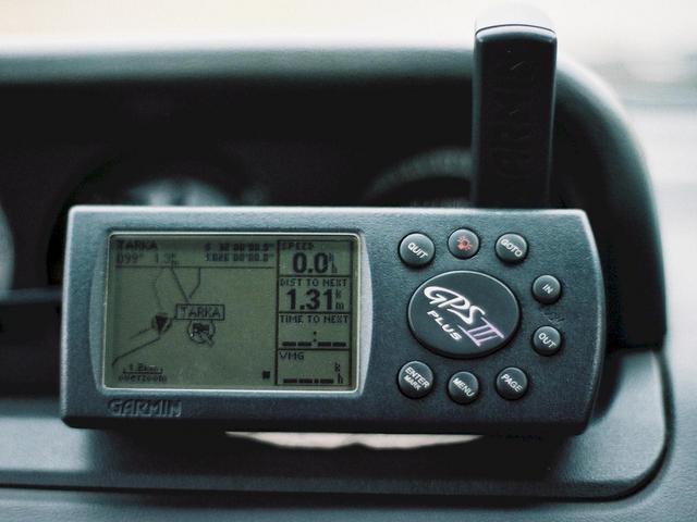
(visited by Peter Hers and Jocelyn Hers) 01-Mar-2002 -- We had made a successful visit to 31S 26E earlier on this day, but it occupied much more time than we had allowed for. By the time we reached 32S 26E we were running late, and still had almost 400 km to travel to our overnight stop at Cape St Francis. Nevertheless we took the back road from Hofmeyr to Tarkastad, and were hoping that this Confluence would be close to the road. From our maps it looked like it could be only a few hundred metres from the road. We reached the closest point, on the tarred road between Tarkastad and Cradock, and discovered we were only about 1.31 km from the Confluence. However, the road was in fact in a "poort" running between some fairly steep hills. The main photo shows a view directly towards the confluence point. In order to get there, one would have to scale a fence, climb down into the gully, and then climb up a fairly steep hill on the other side. Difficult to judge the distance, but it was quite possible that the confluence point would be right over the top of the hill, and I estimated that it would take a good hour to get there, and then the same to get back. So sadly we had to leave this one for a later visit, or for someone else to tackle. Photo #2 shows the point on the track log closest to the confluence point. We travelled a way down the road in order to check whether there was a closer approach, before returning. The last photo shows some of the rocks on the far side of the gully, about 200 metres further down the road, where we stopped for a sandwich and drink of water. |
| All pictures |
| #1: View directly towards the confluence point, about 1.3 km away #2: GPS showing nearest approach on track log #3: Rocks across gulley about 200 metres from nearest point ALL: All pictures on one page |