|
United States : Texas
3.6 miles (5.8 km) S of Cactus, Moore, TX, USA
Approx. altitude: 1108 m
(3635 ft)
([?] maps: Google MapQuest OpenStreetMap topo aerial ConfluenceNavigator)
Antipode: 36°S 78°E
Accuracy: 8 m (26 ft)
Quality: good
Click on any of the images for the full-sized picture.
| 36°N 102°W (visit #1) |

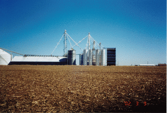
(visited by Robert Fenske, Jr.) 09-Mar-2002 -- A group of us from San Antonio were going skiing in Colorado the week of March 09-16 and we were going there by car. I checked the confluences along the expected route to Colorado and saw that the unvisited 36N 102W confluence was just a little out of the way and very close to the major road US287. As I got back from a business trip on March 07 I ended up having to drive up to Colorado by myself as the rest left before I could get ready. Since I had come back from overseas I still had quite a bit of jet lag which I decided to use to my advantage. I started driving a little after midnight on March 09. By early afternoon I was in the Texas panhandle north of Dumas near the 36N 102W confluence. Moving along US287 with GPS receiver in hand I drove until I swiftly moved past the closest approach. Turning around I more slowly drove until I got closest to the confluence. I pulled off the road and parked just south of a grain silo complex, one of many that dot this part of Texas. The confluence was only 360 meters west of the road in a fallow field. So I got out and starting walking. Under the breezy, cloudless sky in short order I found myself at the confluence. The east view (#1) is the grain silo next to US287. My car is barely visible in the gap to the left of the long white tank at the right of the picture. As you can see from the pictures this area is plenty flat and is all farming country. The west view (#3) has one of the wheeled water delivery machines that moves in one huge circle. The picture of my GPS receiver at the confluence was too blurry to read so I have just the four directional pictures. I didn't stay that long as I still had 700+ kilometers to drive. |
| All pictures |
| #1: looking east #2: looking north #3: looking west #4: looking south ALL: All pictures on one page |


![Visit #2: [22-Jan-11] Visit #2: [22-Jan-11]](/us/tx/n36w102v2/preview.jpg)