|

Eswatini
1.9 km (1.2 miles) S of Lomahasha, Lubombo, Eswatini
Approx. altitude: 613 m
(2011 ft)
([?] maps: Google MapQuest OpenStreetMap ConfluenceNavigator)
Antipode: 26°N 148°W
Accuracy: 15 m (49 ft)
Quality: good
Click on any of the images for the full-sized picture.


| 26°S 32°E (visit #1) |
![Visit #3: [17-Nov-14]](/wz/all/s26e032v3/preview.jpg "Visit #3: [17-Nov-14]")
![Visit #2: [25-Sep-05]](/wz/all/s26e032v2/preview.jpg "Visit #2: [25-Sep-05]")

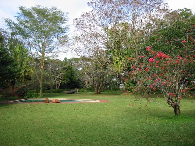
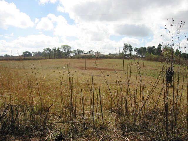
(visited by Walter Sigl, Ellen Lenz, Angela Noske and Heinz Noske) 10-Aug-2002 -- The expedition consisted of a party of 4 members, who where guided once again by Walter Sigl and his Garmin, his friend, Ellen Lenz, my husband Heinz Noske and myself, Angela. We left Johannesburg on 9 August, when we had already mapped the Confluence 26S 30E at around 10 am. We entered the border post Oeshoek into Swaziland at 11h30 and proceeded towards the east, to get as near as possible to the Confluence 26S 32E. After we had traversed the whole country from west to east, we decided to stay overnight at a sugar plantation in Tambankulu a few miles south of Mlume, a very large sugar estate. The Tambankulu lodge was only 14 km away from the Confluence. We decided to call it a day and visit the Confluence on the following morning. We where tired and decided to tuck in early after having a simple meal at the restaurant at the lodge. Next morning we enjoyed a leisurely breakfast at the lodge before leaving for the Confluence. The weather was very nice and we had a nice ride in a northerly direction through mountainous landscape. Shortly before the border we were stopped by a patrol for the prevention of foot and mouth disease. We did not declare our meat, since we would not unpack or eat it outside the safe area and were fortunately not searched. We looked honest enough. At Lomahasha we were harassed by a dozen or so money changers who were hoping to have found tourists for Mozambique. We could not get out of the car and decided to first drive a little bit out of the way to get some peace from the locals. We drove along a sand track in an easterly direction towards the border. After a few meters we decided that it was now safe to leave the vehicles behind and walk the last 100 m on foot. The Confluence was at the edge of a football field inside some burned scrub. While we were busy with the mapping and the photographing, we were watched by some curious locals from a safe distance. A few illegal immigrants tried to take advantage from our activities and moved in, but were picked up by the border patrol and chased back with cocked rifles. We were in the middle of all this and got quite a fright, for we were caught completely unawares. We stood together and looked on, but decided to leave quickly before the situation turned nasty. We managed to take a picture of one of the local women who stood nearby and talked to us all the time in her language. The Confluence seemed to be rather in the middle of the border town of Lomahasha. The area around the Confluence was mountainous but open. In the nearer vicinity were some Fever trees (Acacia xanthophloea) and smaller trees. After mapping we left to carry on southwards to attempt the Confluence 27S 32E. |
| All pictures |
| #1: Looking East #2: Looking North #3: Looking South #4: Looking West #5: GPS reading #6: At the Confluence #7: Old woman #8: Sugar estate lodge ALL: All pictures on one page |
| Notes |
|
The "corner" of the border with Mozambique is about 462 m NE of the Confluence. |