|
France : Bretagne
3.1 km (1.9 miles) SE of Boderel, Morbihan, Bretagne, France
Approx. altitude: 93 m
(305 ft)
([?] maps: Google MapQuest OpenStreetMap ConfluenceNavigator)
Antipode: 48°S 177°E
Accuracy: 16 m (52 ft)
Quality: good
Click on any of the images for the full-sized picture.
| 48°N 3°W (visit #5) |

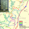
(visited by Henk Pouwels and Inge Pouwels) 30-Sep-2005 -- A three stage visit to a confluence. Our first attempt to visit this confluence was in September 2003. On our way to the camping at the peninsula of Quiberon (about 60 km South) we decided to look for this confluence, without any preparation like checking the confluence site. After probing a lot of small roads by car or by feet we finally walked along the banks of the river Blavet at the lock of Rimaison and came as close as 140 m. This trip is coloured in red on the map. Between the DCP and us was a steep slope covered with all kind of shrubs bearing awful thorns. With a look at the watch we decided to postpone the search to another time, saving some daylight to raise our tent. In September 2004, while returning from another holiday in Quiberon my wife, who is the navigator, told me to leave the main road and to follow her instructions for a detour via a tourist route (green bordered roads of the Michelin maps). After a while I recognised some roads and realised we were in the vicinity of the Blavet-DCP (the Michelin book of maps doesn’t indicate DCP’s). But a renewed search did not fit our time schedule, so we passed by (see the green track). This year, 2005, I decided to go for the DCP. The blue track indicates our path. Driving to the lock the nearest distance from the road to the DCP was 200 m. we stopped the car and spotted a metal roof in the right direction. So we tracked back and found a small road heading north and leading to a farm which brought us as close as 100 m of the DCP. The farmhouse is abandoned and is in a very poor condition. The metal roof was of a large open shed containing several large agricultural vehicles, so the agricultural business is still going on. A short walk along the border of a field with young cabbage plants brought me to another field. In this field the DCP is situated; it is in the yellowish patch of green plants at the right. One could think the large stone in the field at the left is a marker for the DCP, but it is not. Proceeding along the edge of the two fields, without entering the green field, led to the GPS display mounted in the map. From the LAT/LON reading the Indicated Position Error is calculated as 11 m. The Estimated Position Error of this reading as given by the GPS is 5 m. The North, East, South, and West views from this spot are not very spectacular and just slightly indicate how lovely and beautiful the region is. The Blavet valley is a mixture of agricultural land and woods and due to the hilly character full of winding roads and beautiful views. The Blavet is hidden behind the trees and shrubs seen in the North view. It seems there is a narrow, not often used, path from the farm in NE direction leading to the Blavet. There are many old chapels. Four circuits for visiting the chapels and the contempory artworks exhibited inside some of the chapels with their names and co-ordinates. Their positions are also marked in the map by violet squares. My collection of plants around the confluence indicates it is autumn. |
| All pictures |
| #1: the confluence at right in the field, looking South #2: looking North #3: looking East #4: looking South #5: Looking West #6: map with 3 tracks, 3 chapels and GPS display #7: the abandoned farm nearby #8: three of the many chapels #9: four samples of nature around #10: Inge reflecting on 14 successful visits. ALL: All pictures on one page |


![Visit #9: [05-Jun-22] Visit #9: [05-Jun-22]](/fr/all/n48w003v9/preview.jpg)
![Visit #8: [25-Dec-17] Visit #8: [25-Dec-17]](/fr/all/n48w003v8/preview.jpg)
![Visit #7: [02-Sep-16] Visit #7: [02-Sep-16]](/fr/all/n48w003v7/preview.jpg)
![Visit #6: [19-Jun-10] Visit #6: [19-Jun-10]](/fr/all/n48w003v6/preview.jpg)
![Visit #4: [28-Jul-02] Visit #4: [28-Jul-02]](/fr/all/n48w003v4/preview.jpg)
![Visit #3: [04-May-02] Visit #3: [04-May-02]](/fr/all/n48w003v3/preview.jpg)
![Visit #2: [01-May-02] Visit #2: [01-May-02]](/fr/all/n48w003v2/preview.jpg)
![Visit #1: [09-Jul-99] Visit #1: [09-Jul-99]](/fr/all/n48w003/preview.jpg)