|

Germany : Bayern
2.2 km (1.4 miles) SSE of Sinzing-Eilsbrunn, Bayern, Germany
Approx. altitude: 429 m
(1407 ft)
([?] maps: Google MapQuest OpenStreetMap ConfluenceNavigator)
Antipode: 49°S 168°W
Quality: good
Click on any of the images for the full-sized picture.


![]()
![]()


| 49°N 12°E (visit #4) |
![Visit #25: [12-Jun-24]](/de/all/n49e012v25/preview.jpg "Visit #25: [12-Jun-24]")
![Visit #22: [27-Jul-22]](/de/all/n49e012v22/preview.jpg "Visit #22: [27-Jul-22]")
![Visit #23: [29-Oct-19]](/de/all/n49e012v23/preview.jpg "Visit #23: [29-Oct-19]")
![Visit #21: [28-Jul-18]](/de/all/n49e012v21/preview.jpg "Visit #21: [28-Jul-18]")
![Visit #20: [19-Sep-15]](/de/all/n49e012v20/preview.jpg "Visit #20: [19-Sep-15]")
![Visit #24: [15-Aug-15]](/de/all/n49e012v24/preview.jpg "Visit #24: [15-Aug-15]")
![Visit #19: [16-Jul-14]](/de/all/n49e012v19/preview.jpg "Visit #19: [16-Jul-14]")
![Visit #18: [05-Apr-14]](/de/all/n49e012v18/preview.jpg "Visit #18: [05-Apr-14]")
![Visit #16: [22-Dec-12]](/de/all/n49e012v16/preview.jpg "Visit #16: [22-Dec-12]")
![Visit #15: [01-Mar-11]](/de/all/n49e012v15/preview.jpg "Visit #15: [01-Mar-11]")
![Visit #14: [22-Jun-10]](/de/all/n49e012v14/preview.jpg "Visit #14: [22-Jun-10]")
![Visit #12: [09-Jul-08]](/de/all/n49e012v12/preview.jpg "Visit #12: [09-Jul-08]")
![Visit #11: [16-Jan-08]](/de/all/n49e012v11/preview.jpg "Visit #11: [16-Jan-08]")
![Visit #13: [26-Oct-07]](/de/all/n49e012v13/preview.jpg "Visit #13: [26-Oct-07]")
![Visit #10: [12-Sep-07]](/de/all/n49e012v10/preview.jpg "Visit #10: [12-Sep-07]")
![Visit #9: [11-May-05]](/de/all/n49e012v9/preview.jpg "Visit #9: [11-May-05]")
![Visit #8: [18-Jun-04]](/de/all/n49e012v8/preview.jpg "Visit #8: [18-Jun-04]")
![Visit #7: [19-May-04]](/de/all/n49e012v7/preview.jpg "Visit #7: [19-May-04]")
![Visit #6: [23-Feb-02]](/de/all/n49e012v6/preview.jpg "Visit #6: [23-Feb-02]")
![Visit #5: [02-Feb-02]](/de/all/n49e012v5/preview.jpg "Visit #5: [02-Feb-02]")
![Visit #3: [29-Mar-01]](/de/all/n49e012v3/preview.jpg "Visit #3: [29-Mar-01]")
![Visit #2: [24-Mar-01]](/de/all/n49e012v2/preview.jpg "Visit #2: [24-Mar-01]")
![Visit #1: [17-Mar-01]](/de/all/n49e012/preview.jpg "Visit #1: [17-Mar-01]")
![Visit #17: [28-Aug-13]](/de/all/n49e012v17/preview.jpg "Visit #17: [28-Aug-13]")

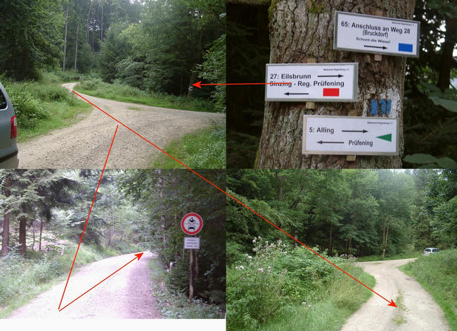
(visited by Hans Augdoppler, Mathias and Leo Donhauser) 13-Aug-2001 -- On our way from Linz to Brandenburg we were able to visit some confluences close to our traveling route. First of all we chose the this spot in order to proof the easy access. We left the ‘Autobahn A3’ and made the approach from south and west via the village of Eilsbrunn. We had to cross the Autobahn twice and entered the road as shown. Since the access route was well described by our predecessors we found the confluence at exact the same location (!). Unfortunately the daylight in early morning was not strong enough to take good pictures from the confluence. Up to now nobody mentioned that the road to the confluence is a prohibited access. From the spot you can hear the roaring noises of the ‘Autobahn A3’.
Upper map in pic#2 was provided by the © Bayer. Landesvermessungsamt
http://www.bayern.de/vermessung |
| All pictures |
| #1: Confluence within the trees and poor light condition #2: Maps showing our approach to the spot #3: Our route via Eilsbrunn #4: Entry point from the ST2394 #5: Full panorama direct in front of the confluence #6: Various views of the approach route #7: Access route underneath the Autobahn ALL: All pictures on one page |
| Plans |
|
Hakan Tandogan
plans to visit this confluence on the 31-Dec-2026. Comments: "Near Regensburg" |