|

Canada : Nova Scotia
10.0 km (6.2 miles) NW of Sable Island, NS, Canada
Approx. altitude: 0 m
(0 ft)
([?] maps: Google MapQuest OpenStreetMap topo topo250 ConfluenceNavigator)
Antipode: 44°S 120°E
Accuracy: 31 m (101 ft)
Quality: good
Click on any of the images for the full-sized picture.


| 44°N 60°W |

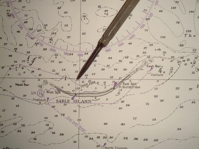
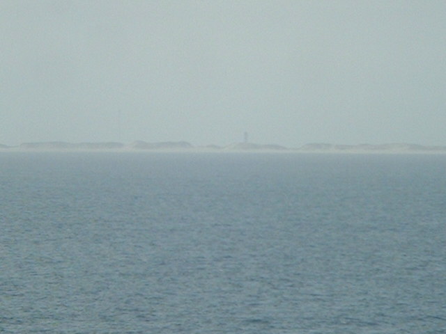
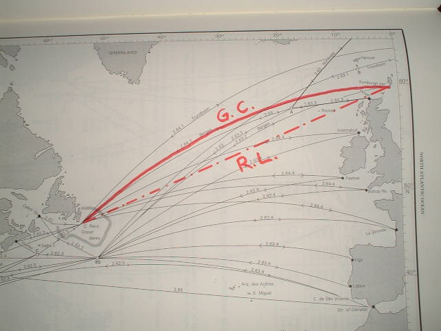
(visited by Captain Peter, Volodymyr Kokorev and Volodymyr Sydorenko) 17-Jun-2002 -- Sailing from the Pentland Firth North of Scotland on the Great Circle Route to the Cape Race (Southeastern tip of Newfoundland), thence to the Straits of Florida and finally to Pascagoula MS, today we passed Sable Island, in which vicinity there is 44°N/60°W. Sable Island lies 150 naut. miles (280 km) ESE of Halifax (Nova Scotia) on Sable Island Bank, and with its adjacent shoals it is a serious hazard to shipping. The Island is reported to moving slowly East, the action of the wind and sea causing the sea to encroach on the West end and the land to extend at the East end. Sable Island consists of a narrow crescent of sand about 37 km long and less than 1,8 km wide formed by two nearly parallel sand ridges which terminate at their West end in West Spit, and at their East end in East Spit. The ridges are shaped by winds into hills which frequently change their position, Many of these hills terminate in steep cliffs while others are covered with grass behind broad sandy beaches. There are shrubs but no trees. The South Ridge seldom rises to a height of more then 4-6 metres, but the North Ridge attains heights of up to 24 metres. The island is generally featureless apart from East and West End Lighthouses. Further there are buildings of a meteorological station and several radio masts near West Spit. The most prominent radar target is the tower of West End Lighthouse. The Canadian Wild Life Service and the Department of Fisheries and Oceans have stations located about 1 km SE of East Spit. These are inhabited for about 6 months of the year. The Canadian Atmospheric Environment Service maintains a meteorological station near West End Lihthouse which is manned throughout the year. A herd of wild ponies exists on the island, sustained by the sparse vegetation. Sable Island is administered by the Government of Canada. Except for emergencies no person is allowed to land, visit or reside on the island without permission of the District Manager of the Canadian Coastguard (residing at Dartmouth, Nova Scotia). Above we mentioned the word "Great Circle". What is Great Circle Sailing? First of all we have to remember that Earth is a sphere. Shortly spoken, a ship (or an airplane) has two possibilities to perform a voyage: On short distances, when sailing along the coast from cape to cape, in restricted waters or in traffic separation schemes, "straight" courses are maintained. Such courses appear on the map as straight lines. This is the so called "Rhumb Line Sailing". But rhumb line sailing has a disadvantage: A course on a rhumb line is NOT the shortest connection between two points! Whenever feasible, however, especially on long open ocean passages in preferably East-West-directions, the navigator will choose to sail on a Great Circle. Feasibility depends mostly on meteoroloical circumstances. A Great Circle is a circle whose plain intersects with the centre of the Earth. So we know already two kinds of natural Great Circles: 1- the Equator 2- all Meridians, and so we understand that when sailing on North-South directions, a Great Circle is not necessary to be calculated, as you anyway follow it, when sailing along a meridian. Sailing on such a line means automatically to sail on the shortest distance between two points. Through any two points on the Earth a Great Circle can be put. This requires a basic knowledge of spheric trigonometry. Triangles on a plain area differ from those on a sphere. The sum of the three angles in a plain triangle is always 180°, a spheric triangle, however, can have more then 180°. It would not take us anywhere to develop the necessary formulas here, a mathematician called Napier did it already for us, many centuries ago. On a map a Great Circle (G.C.) appears as a poleward bended line. It is no longer a straight Rhumb Line (R.L.), but a kind of arch consisting of many different courses, to be altered at e.g. every 5° of longitude accordingly. And now we do understand why it is not always feasible to sail on it. Often the Great Circle brings you too much North into bad weather. The selection of the best track for a passage demands skilled evaluation of a number of factors, the principal of which or the sea conditions, winds and currents which it is expected to encounter, and the way the ship herself will react to them. The North part of the Atlantic Ocean experiences predominantly unsettled weather on the Northern side of the oceanic anticycloons (High pressures). As a result of the almost continuous passage of depressions across this zone the wind varies greatly in direction and strength, and there is a high frequency of strong winds. Gales are common. The stormiest belt extends roughly from the vicinity of Newfoundland to the channel between Iceland and Scotland. The central and East sections of this belt are especially stormy and strong winds may be expected throughout the year. This time, however, we could perform a perfect Great Circle. Lets calculate how much time and fuel we saved with it:
Departure point: Pentland Firth (Scotland) 58°45'N / 3°10'W
Rhumb Line distance:
only one course (248°)
1945 nautical miles
Difference: 46 nautical miles (85 km) saved.
In money:
Fuel consumption per hour: about 1000 litres (285 gallons) This is not yet a big deal, but it is not all. Charterers pay for the ship about 6,000 US$ (6,840 €) hire per day. So in three hours it equals to 750 US$ (855 €). Total amount saved: 1,320 US$ (1,500 €). Not a big deal as well - in shipping they sometimes do waste far higher amounts for nothing, but take a ship that performs about 20 such voyages a year, and take a shipowner having 50 ships on this route, then the choice between Great Circle and Rhumb Line becomes very important. More than a million per year - just because of these 45 nautical miles! And three hours can be crucial in shipping as well: Arriving three hours too late could mean you just missed the tide in the arrival port, and have to wait now for 6 hours idle for the next highwater, stevedores could have been ordered for 8 a.m. and you arrive with your ruddy vase nicely at 11 a.m. (horrible amounts for so called 'standby-times' - especially in the US), or due to your late arrival pilots decided to take in another ship instead of you and you are now waiting one week at the anchorage until she cleared the berth ... all this has to be taken into consideration. The consequences are so horrible that we not even dare to think about them. But never the Captin will be refunded for his economical performance. All this beautiful money remains with the shipowner and charterer. But if you as Captain once do not perform nicely, they will not be sparing with 'love letters' ... "Explain soonest why you did not ... advise immediately how this could happen ... do really not understand why you ..." That's nowaday's merchant shipping biz ... A word to yacht owners regarding Great Circle Sailing: If you are not a professional or participating in a race you should refrain from Great Circle Sailing. The Great Circle usually brings you too much North polewards (or South, when on Southern Hemisphere) and sudden weather changes can cause you trouble, even distress. According to SOLAS (Safety Of Life At Sea Convention) it is my duty to assist and rescue you, then. I will do that with great pleasure. But picture that with a water temperature of 4°C (39°F) your chance to survive is only a 40 minutes and it is not very likely that I am always on the scene just when needed and whether I am able to manoevre alongside you and pick you up in time. For a Trans-Atlantic passage, lets say from the Straits of Florida to Northern Europe, yacht owners should always choose a Southern route, where more land is close (Bermuda, Azores), the water is warmer and more ships are underway to assist in case of distress. Have a nice sailing!
------------------------------------------ Drawing of the Great Circle Routes obtained from: "Ocean Passages for the World", Naut. Publication Nr. 136, 4th Edition, 1987, British Admiralty, Ministry of Defense, Taunton, England |
| All pictures |
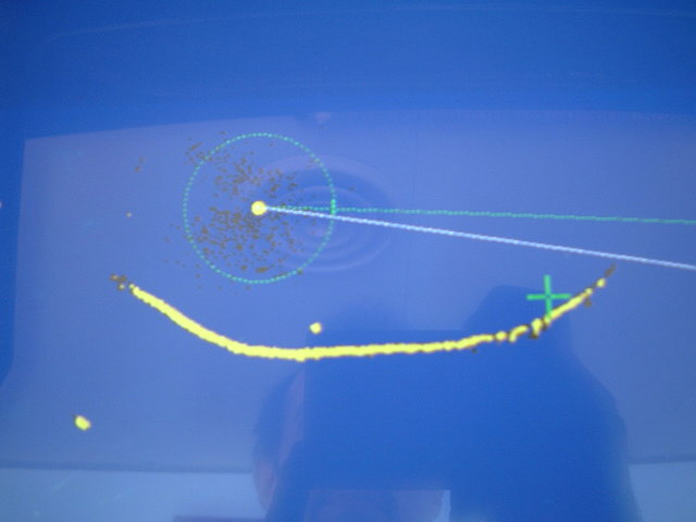
| #1: Sable Island seen from the confluence, off the coast a Canadian research vessel #2: Map #3: GPS #4: Radar #5: The sea is heavily breaking on West Spit #6: West End Lighthouse #7: Great Circle course ALL: All pictures on one page |
| Notes |
|
In the Atlantic Ocean, but with a view of land. |