|
Russia : Respublika Tatarstan
3.9 km (2.4 miles) WSW of Yekaterininskaya sloboda, Respublika Tatarstan, Russia
Approx. altitude: 175 m
(574 ft)
([?] maps: Google MapQuest OpenStreetMap ConfluenceNavigator)
Antipode: 55°S 129°W
Accuracy: 10 m (32 ft)
Quality: good
Click on any of the images for the full-sized picture.
| 55°N 51°E (visit #2) |
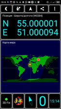
 (visited by Mikhail Romashov and Vitaliy Romashov) 12-Июня-2019 – На нашем пути в Самарскую область было две конфлюентные точки. Это точка с координатами 55°с.ш. и 51°в.д. около посёлка Екатерининская Слобода. Точка пересечения координат оказалась в центре маленького, но очень гордого леса. Мы так и не смогли найти в него заезд, и в итоге нам пришлось продираться 1,5 километра через заросли по кабаньим и лосиным тропам. Точку мы всё-таки нашли и отметили, а на обратном пути ещё и подосиновиков насобирали. Поскольку в условиях сплошного леса из-за плохого приёма искать точку трудно, мы потратили немало времени на получение достаточно точных координат. Для тех, кто придёт за нами, мы закрепили на дереве ориентир. Чтобы не нанести дереву вред мы прикрепили звезду в толстый кусок коры коротким шурупом который вошёл в неё максимум на 2 мм, так что ни одно дерево не пострадало, ну не считая десятка другого, через которые нам пришлось ломиться пока мы туда шли :). Но это точно не пострадало. Следующая точка 54°N 51°E. 12-Jun-2019 – On our way to the Samara region there were two confluence points. One of them is a point with coordinates of 55°N 51°E near the village Ekaterininskaya Sloboda. The confluence is located in the center of a small, but very proud forest. We could not find an auto-entrance into it, and as a result, we had to scramble 1.5 km through thickets along boar and moose paths. We did find the confluence point and noted it, but on the way back we also gathered some 'aspen' mushrooms [Leccinum aurantiacum]. Since it is difficult to fix a precise point due to poor reception in the conditions of a solid forest, we spent a lot of time getting quite accurate coordinates. For those who will come after us, we have fixed a landmark on the tree. In order not to harm the tree, we attached a star to a thick piece of bark with a short screw that entered by (maximum) 2 mm, so no tree was damaged, well, not counting a dozen others, which we had to break through while we were hiking there :). But this one certainly did not suffer. The next confluence was 54°N 51°E. |
| All pictures |
| #1: #2: #3: #4: #5: ALL: All pictures on one page |


![Visit #3: [16-Jul-23] Visit #3: [16-Jul-23]](/ru/all/n55e051v3/preview.jpg)
![Visit #1: [14-Jun-09] Visit #1: [14-Jun-09]](/ru/all/n55e051/preview.jpg)