
| { Main | Search | Countries | Information | Member Page } | |
United States : Texas; showing visits by Alfredo B. Remon Mendez |
| There are no Plans for this Region. |
| Region Notes |

|
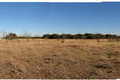
31°N 97°W 1.1 miles (1.7 km) S of Burlington, Milam, TX, USA [25-Jun-12] |
|
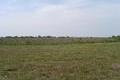
32°N 98°W 2.3 miles (3.7 km) NE of Hico, Hamilton, TX, USA [04-Feb-11] |

|
32°N 96°W 3.3 miles (5.3 km) NNW of Cayuga, Anderson, TX, USA [04-Feb-11] |

|
33°N 95°W 2.0 miles (3.2 km) W of Pittsburg, Camp, TX, USA [incomplete] [04-Feb-11] |

|
33°N 97°W 3.2 miles (5.1 km) S of Lewisville, Denton, TX, USA [04-Feb-11] |

|
31°N 95°W 2.8 miles (4.5 km) SE of Woodlake, Trinity, TX, USA [02-Jun-05] |
|
30°N 96°W 4.6 miles (7.4 km) SSE of Pine Island, Waller, TX, USA [10-May-05] |

|
29°N 96°W 2.2 miles (3.5 km) NW of Bay City, Matagorda, TX, USA [10-May-05] |
Region Notes:
The Texas Department of Transportation has their Texas Official Travel Map available for download as a PDF file. The map includes latitude/longitude grid tic marks that have been placed at the Degree Confluences. Information on the map projections used in Texas can be found at the TNRIS website.