
| { Main | Search | Countries | Information | Member Page } | |
United States : Texas; showing visits by Gordon Spence |
| There are no Plans for this Region. |
| Region Notes |
|
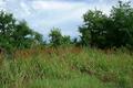
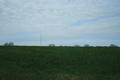
31°N 97°W 1.1 miles (1.7 km) S of Burlington, Milam, TX, USA [04-Jun-02] |
|
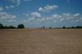
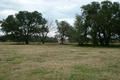
30°N 96°W 4.6 miles (7.4 km) SSE of Pine Island, Waller, TX, USA [29-May-02] |

|
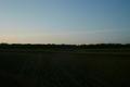
29°N 96°W 2.2 miles (3.5 km) NW of Bay City, Matagorda, TX, USA [29-May-02] |
|
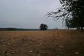
30°N 95°W 5.4 miles (8.8 km) ESE of Huffman (Harris), Liberty, TX, USA [29-May-02] |
|
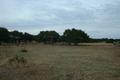
31°N 98°W 5.6 miles (9.0 km) S of Kempner (Lampasas), Burnet, TX, USA [06-Mar-02] |
|
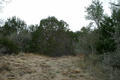
31°N 99°W 6.4 miles (10.2 km) NNW of Pontotoc (Mason), San Saba, TX, USA [incomplete] [06-Mar-02] |
|
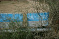
30°N 99°W 4.4 miles (7.1 km) NNE of Center Point, Kerr, TX, USA [06-Mar-02] |
|
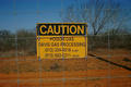
29°N 100°W 9.9 miles (16.0 km) WNW of La Pryor, Zavala, TX, USA [incomplete] [06-Mar-02] |
|
29°N 99°W 3.9 miles (6.2 km) S of Moore, Frio, TX, USA [incomplete] [06-Mar-02] |
|
29°N 98°W 1.6 miles (2.6 km) NE of Falls City, Karnes, TX, USA [06-Mar-02] |
|
30°N 97°W 1.0 miles (1.7 km) SE of Winchester, Fayette, TX, USA [05-Feb-02] |
Region Notes:
The Texas Department of Transportation has their Texas Official Travel Map available for download as a PDF file. The map includes latitude/longitude grid tic marks that have been placed at the Degree Confluences. Information on the map projections used in Texas can be found at the TNRIS website.