|

United Kingdom : England
3.0 km (1.9 miles) NW of Fletching, East Sussex, England, United Kingdom
Approx. altitude: 25 m
(82 ft)
([?] maps: Google MapQuest OpenStreetMap ConfluenceNavigator)
Antipode: 51°S 180°
Accuracy: 4 m (13 ft)
Quality: good
Click on any of the images for the full-sized picture.


| 51°N 0° (visit #2) |
![Visit #25: [02-Sep-25]](/uk/en/n51e000v25/preview.jpg "Visit #25: [02-Sep-25]")
![Visit #24: [01-Oct-19]](/uk/en/n51e000v24/preview.jpg "Visit #24: [01-Oct-19]")
![Visit #22: [05-Jan-16]](/uk/en/n51e000v22/preview.jpg "Visit #22: [05-Jan-16]")
![Visit #21: [02-Feb-15]](/uk/en/n51e000v21/preview.jpg "Visit #21: [02-Feb-15]")
![Visit #20: [01-Mar-13]](/uk/en/n51e000v20/preview.jpg "Visit #20: [01-Mar-13]")
![Visit #19: [14-Nov-12]](/uk/en/n51e000v19/preview.jpg "Visit #19: [14-Nov-12]")
![Visit #18: [31-Jul-11]](/uk/en/n51e000v18/preview.jpg "Visit #18: [31-Jul-11]")
![Visit #17: [31-Jul-11]](/uk/en/n51e000v17/preview.jpg "Visit #17: [31-Jul-11]")
![Visit #16: [20-Aug-10]](/uk/en/n51e000v16/preview.jpg "Visit #16: [20-Aug-10]")
![Visit #14: [19-May-10]](/uk/en/n51e000v14/preview.jpg "Visit #14: [19-May-10]")
![Visit #15: [01-Apr-10]](/uk/en/n51e000v15/preview.jpg "Visit #15: [01-Apr-10]")
![Visit #13: [25-Sep-09]](/uk/en/n51e000v13/preview.jpg "Visit #13: [25-Sep-09]")
![Visit #12: [20-Apr-09]](/uk/en/n51e000v12/preview.jpg "Visit #12: [20-Apr-09]")
![Visit #11: [15-Jul-08]](/uk/en/n51e000v11/preview.jpg "Visit #11: [15-Jul-08]")
![Visit #10: [15-Jul-08]](/uk/en/n51e000v10/preview.jpg "Visit #10: [15-Jul-08]")
![Visit #8: [26-Dec-05]](/uk/en/n51e000v8/preview.jpg "Visit #8: [26-Dec-05]")
![Visit #7: [26-Jul-05]](/uk/en/n51e000v7/preview.jpg "Visit #7: [26-Jul-05]")
![Visit #6: [11-Dec-04]](/uk/en/n51e000v6/preview.jpg "Visit #6: [11-Dec-04]")
![Visit #5: [08-Apr-04]](/uk/en/n51e000v5/preview.jpg "Visit #5: [08-Apr-04]")
![Visit #4: [08-Apr-04]](/uk/en/n51e000v4/preview.jpg "Visit #4: [08-Apr-04]")
![Visit #3: [22-Apr-02]](/uk/en/n51e000v3/preview.jpg "Visit #3: [22-Apr-02]")
![Visit #1: [09-Jul-00]](/uk/en/n51e000/preview.jpg "Visit #1: [09-Jul-00]")
![Visit #9: [29-Jul-07]](/uk/en/n51e000v9/preview.jpg "Visit #9: [29-Jul-07]")

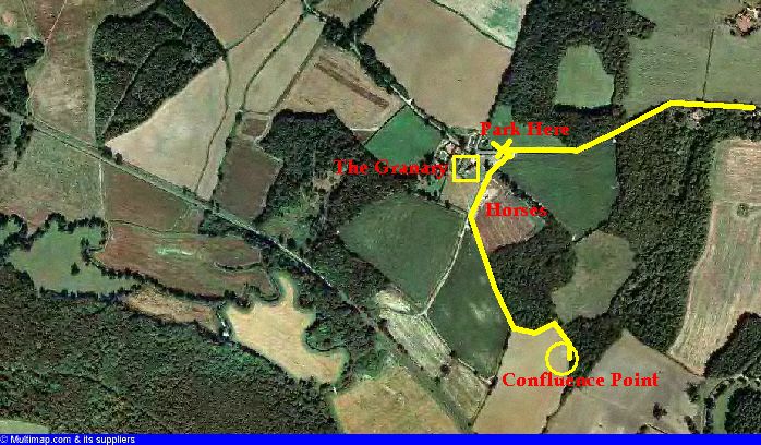
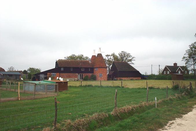
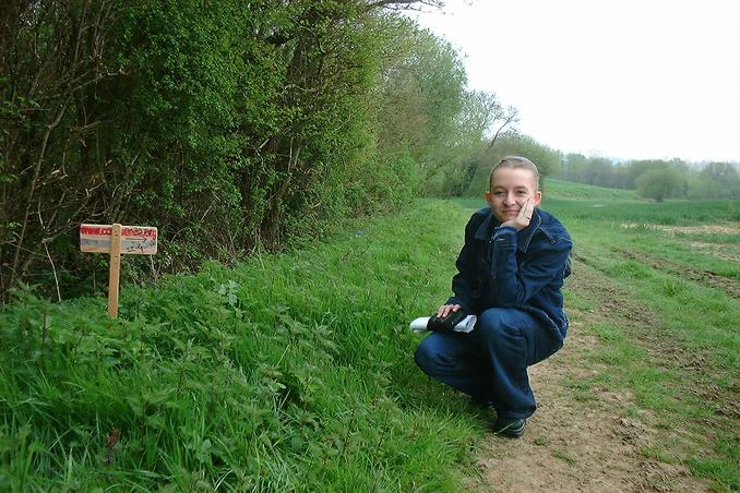
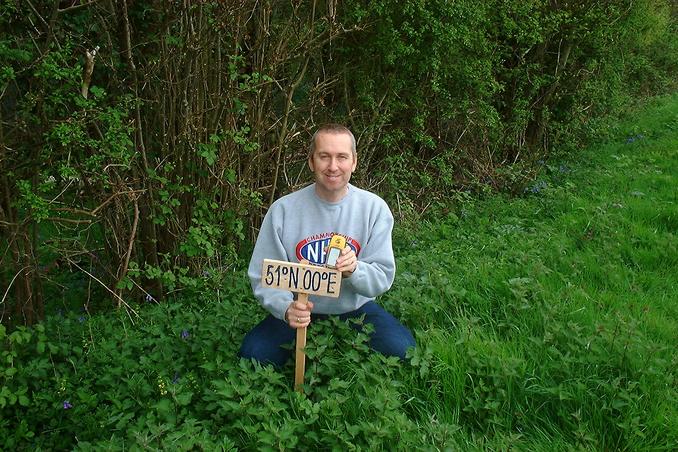
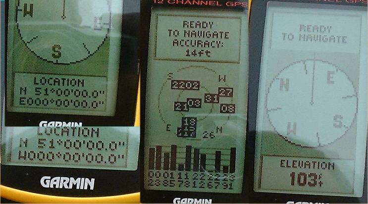
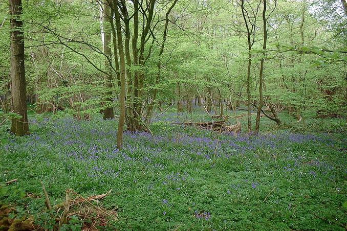
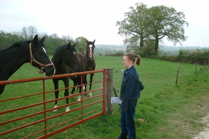
(visited by Gordon Spence and Rachel Spence) 24-Apr-2002 -- I had been planning to start doing the row of confluences on the Southern most degree of longitude in the UK (51N) for quite a while. Today presented the chance as we had to pay a visit to the Orthodontist's in that part of the country. I checked the site and extracted all the relevant details and noticed that it had only been visited once before, nearly two years ago. No accuracy figure was recorded. We left home just before 8am for the 150 mile trip to the point, I expected some traffic as it was rush hour but we lost nearly an hour to three separate lots of road-works. Following the maps and the aerial photo (annotated after the visit) we parked up. I approached "The Granary", the two conical towers you can see used to house the grinding wheels to make the flour. There was nobody home bar a fierce and loud dog! In the absence of any signs to indicate we shouldn't proceed - bar a sign left over from last year's foot & mouth outbreak, the UK was declared disease free a few months ago - we set off to find the point. As we zeroed in using the GPS I noticed a marker of some sort at the side of the field, closer examination revealed that I was the third visitor not the second! Someone had been there two days ago. They have not submitted the report yet. Picture 5 shows Rachel by the sign and Picture 6 shows me with the sign. The field has been planted, however by using the small bare patches and the blank ruts caused by the tractor when it was planted, it was possible to reach "the spot". It was at this point that I noticed a "feature" in the GPS software. The latitude kept flipping between W000 and E000 degrees! A full bag of birds gave an accuracy of 4M and altitude is higher than stated at 107 feet. Looking South is the typical rolling countryside of this part of England, while just to the North of the field is a lovely Bluebell wood. Making our way back to the car, I found what is fast becoming a regular feature of my UK confluence points - a few horses. By the time we finally got home we had had an 11 hour and 359 mile day, all in all a good day out. |
| All pictures |
| #1: Looking South #2: Bluebell wood to the North #3: Oast House #4: GPS collage #5: Rachel and the marker #6: Gordon and the marker #7: Rachel with the horses #8: Courtesy of multimap.com ALL: All pictures on one page |