
| { Main | Search | Countries | Information | Member Page } | |
Older Confluence Visits (15972 to 16021) |
This list is based on the date the confluence visit is posted to the site (not the date of the visit).
|
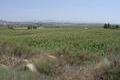
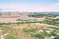
42°N 0° 4.1 km (2.5 miles) E of Laluenga, Huesca, Aragón, Spain [incomplete] [19-Sep-02] |

|
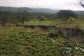
17°S 142°E 8.8 km (5.5 miles) SE of Yagoonya, QLD, Australia [incomplete] [19-Sep-02] |
|
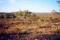
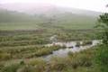
28°S 118°E 16.6 km (10.3 miles) ENE of Mount Magnet, WA, Australia [19-Sep-02] |
|
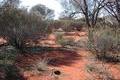
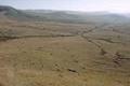
16°S 128°E 60.2 km (37.4 miles) S of Wyndham, WA, Australia [19-Sep-02] |
|
39°N 1°W 4.0 km (2.5 miles) NNE of La Torre, Valencia, Valencia, Spain [incomplete] [19-Sep-02] |
|
47°N 120°W 3.8 miles (6.1 km) N of Vantage (Kittitas), Grant, WA, USA [19-Sep-02] |
|
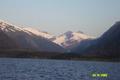
61°N 148°W 27.9 miles (44.9 km) NE of Whittier, Valdez-Cordova, AK, USA [19-Sep-02] |
|
46°N 114°W 7.6 miles (12.2 km) NE of Conner, Ravalli, MT, USA [19-Sep-02] |
|
49°N 98°W 6.5 miles (10.4 km) NW of Walhalla (Pembina), Cavalier, ND, USA [19-Sep-02] |
|
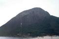
23°S 43°W 3.6 km (2.2 miles) SE of Ponta de Itacoatiara (Cape), Rio de Janeiro, Brazil [incomplete] [18-Sep-02] |
|
30°S 71°W 1.6 km (1.0 miles) E of Talca, Coquimbo, Chile [17-Sep-02] |

|
47°N 72°W 7.9 km (4.9 miles) WNW of Rivière-Mauvaise, QC, Canada [17-Sep-02] |
|
47°N 91°W 2.8 miles (4.5 km) NW of Sand Island, Bayfield, WI, USA [16-Sep-02] |
|
51°N 109°W 18.7 km (11.6 miles) NNE of Lemsford, SK, Canada [16-Sep-02] |
|
47°N 66°W 8.7 km (5.4 miles) NNW of Halcomb, NB, Canada [16-Sep-02] |
|
62°N 22°E 4.5 km (2.8 miles) NW of Rynkäinen, Länsi-Suomen lääni, Finland [16-Sep-02] |

|
59°N 13°E 5.3 km (3.3 miles) SW of Rud, Värmland, Sweden [16-Sep-02] |
|
61°N 10°E 19.0 km (11.8 miles) N of Dokka, Oppland, Norway [16-Sep-02] |

|
51°N 114°W 1.2 km (0.7 miles) NE of Ogden, Calgary, AB, Canada [15-Sep-02] |
|
63°N 26°E 4.6 km (2.9 miles) WSW of Suovanlahti, Länsi-Suomen lääni, Finland [secondary] [15-Sep-02] |
|
56°N 122°W 6.9 km (4.3 miles) WSW of Hudson's Hope, BC, Canada [secondary] [15-Sep-02] |
|
55°N 121°W 14.0 km (8.7 miles) S of Tumbler Ridge, BC, Canada [incomplete] [15-Sep-02] |
|
55°N 123°W 2.9 km (1.8 miles) ENE of McLeod Lake, BC, Canada [15-Sep-02] |
|
51°N 123°W 20.1 km (12.5 miles) NW of Gold Bridge, BC, Canada [15-Sep-02] |
|
33°S 18°E 6.1 km (3.8 miles) E of Saldanha, Western Cape, South Africa [15-Sep-02] |
|
29°S 30°E 12.1 km (7.5 miles) E of Estcourt, KwaZulu-Natal, South Africa [15-Sep-02] |
|
31°S 30°E 1.8 km (1.1 miles) SSW of Lugwijini, Eastern Cape, South Africa [15-Sep-02] |
|
31°S 29°E 1.7 km (1.1 miles) N of Mpemba, Eastern Cape, South Africa [15-Sep-02] |
|
30°S 29°E 21.2 km (13.2 miles) E of Hill Top, Qacha's Nek, Lesotho [15-Sep-02] |
|
29°S 28°E 2.5 km (1.6 miles) SE of Corn Exchange, Berea, Lesotho [15-Sep-02] |
|
29°S 27°E 9.2 km (5.7 miles) SW of Excelsior, Free State, South Africa [15-Sep-02] |

|
34°N 119°W 10.9 miles (17.5 km) W of Malibu (Los Angeles), Ventura, CA, USA [13-Sep-02] |
|
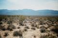
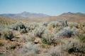
38°N 116°W 24.0 miles (38.7 km) SE of Warm Springs, Nye, NV, USA [13-Sep-02] |

|
38°N 120°W 4.3 miles (6.9 km) NNE of Femmons, Tuolumne, CA, USA [13-Sep-02] |
|
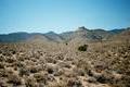
37°N 115°W 26.4 miles (42.5 km) SSE of Alamo, Lincoln, NV, USA [13-Sep-02] |
|
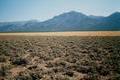
38°N 115°W 30.3 miles (48.9 km) NNE of Hiko, Lincoln, NV, USA [13-Sep-02] |
|
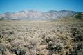
39°N 115°W 6.7 miles (10.8 km) NNE of Preston, White Pine, NV, USA [13-Sep-02] |
|
37°N 107°W 4.6 miles (7.4 km) N of Dulce, Rio Arriba, NM, USA [incomplete] [13-Sep-02] |
|
40°N 115°W 9.2 miles (14.8 km) NW of Cherry Creek, White Pine, NV, USA [13-Sep-02] |
|
61°N 148°W 27.9 miles (44.9 km) NE of Whittier, Valdez-Cordova, AK, USA [13-Sep-02] |
|
41°N 115°W 7.9 miles (12.7 km) SSW of Wells, Elko, NV, USA [12-Sep-02] |
|
41°N 116°W 16.9 miles (27.2 km) NW of Elko, Elko, NV, USA [12-Sep-02] |
|
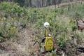
39°N 108°W 3.9 miles (6.3 km) SW of Grand Mesa, Delta, CO, USA [12-Sep-02] |
|
41°N 118°W 14.0 miles (22.5 km) W of Winnemucca, Humboldt, NV, USA [12-Sep-02] |
|
40°N 121°W 2.2 miles (3.5 km) SE of Hot Springs, Plumas, CA, USA [12-Sep-02] |
|
69°N 144°W 71.9 miles (115.7 km) NE of Arctic Village (Yukon-Koyukuk), North Slope, AK, USA [12-Sep-02] |
|
39°N 102°W 9.4 miles (15.1 km) N of Weskan, Wallace, KS, USA [12-Sep-02] |
|
35°S 56°W 9.2 km (5.7 miles) SW of Isla de Flores (Island), Canelones, Uruguay [incomplete] [11-Sep-02] |

|
55°N 117°W 19.4 km (12.0 miles) ESE of Valleyview, AB, Canada [10-Sep-02] |
|
67°N 23°E 4.7 km (2.9 miles) NE of Nuoksujärvi, Norrbotten, Sweden [secondary] [10-Sep-02] |